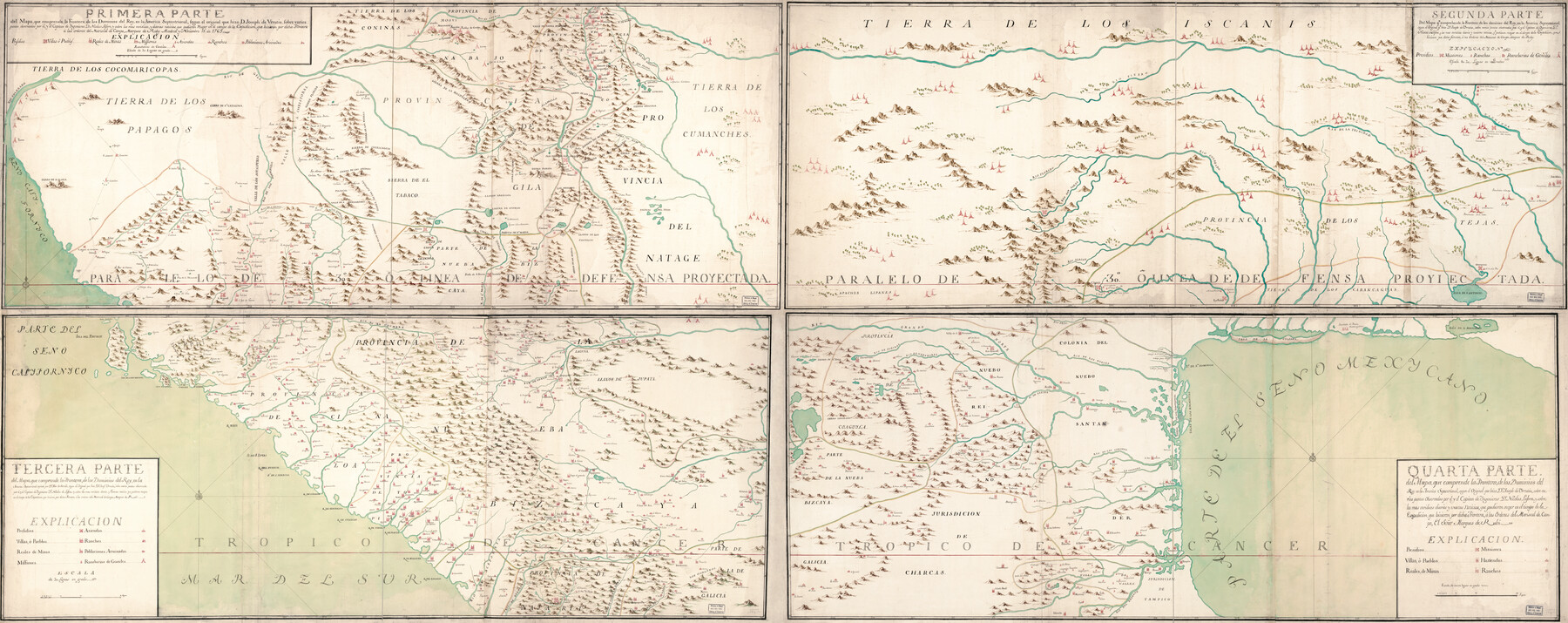
Mapa que comprende la Frontera de los Dominios del Rey, en la America Septentrional, segun el original que hizo D. Joseph de Urrutia, sobre varios puntos observados por él, y el Capitan de Yngenieros D. Nicolas Lafora
-
Map/Doc
95711
-
Collection
Library of Congress
-
Object Dates
11/18/1769 (Creation Date)
-
People and Organizations
Joseph de Urrutia (Cartographer)
Nicolás de Lafora (Surveyor/Engineer)
Luis de Surville (Draftsman)
-
Subjects
Spanish Texas
-
Height x Width
50.9 x 128.2 inches
129.3 x 325.6 cm
-
Medium
digital image
-
Comments
Copied by Luis de Surville according to original made by Joseph de Urrutia on various points observed by him and the Captain of Engineering, Nicolas de Lafora. See also: maps 3062, 4667, and 95311
Related maps
Primera parte del Mapa, que comprende la Frontera, de los Dominios del Rey, en la America Septentrional

Print $40.00
- Digital $50.00
Primera parte del Mapa, que comprende la Frontera, de los Dominios del Rey, en la America Septentrional
1769
Size 25.8 x 63.2 inches
Map/Doc 3062
Segunda parte del Mapa, que comprende la Frontera, de los Dominios del Rey, en la America Septentrional

Print $40.00
- Digital $50.00
Segunda parte del Mapa, que comprende la Frontera, de los Dominios del Rey, en la America Septentrional
1769
Size 26.7 x 63.8 inches
Map/Doc 4667
Mapa de toda la Frontera de los dominios del Rey en la America septentrional

Print $40.00
Mapa de toda la Frontera de los dominios del Rey en la America septentrional
1771
Size 26.4 x 50.0 inches
Map/Doc 95311
Plano del Presidio de Nra. Senora del Pilar de los Adaes, Capital de la Provincia de los Tejas situado en 32 grados y 15 minutos de Latitud Boreal, y en 285° y 52' de Longitud respecto del Meridiano de Tenerife

Plano del Presidio de Nra. Senora del Pilar de los Adaes, Capital de la Provincia de los Tejas situado en 32 grados y 15 minutos de Latitud Boreal, y en 285° y 52' de Longitud respecto del Meridiano de Tenerife
Size 16.9 x 21.4 inches
Map/Doc 96563
Plano de la Villa y Presidio de S. Antonio de Vejar situado en la Provincia de Tejas en 29 grad. y 52 minutos de latitud bor. y 275° y 57' de long. contados desde de Meridiano d. Tenerife

Plano de la Villa y Presidio de S. Antonio de Vejar situado en la Provincia de Tejas en 29 grad. y 52 minutos de latitud bor. y 275° y 57' de long. contados desde de Meridiano d. Tenerife
1768
Size 16.8 x 21.2 inches
Map/Doc 96564
Plano del Presidio de Bahia dela Espiritu Santo dependite dela Governacion de los Tejas situado en 29 grad. Y 39 min. de latitud boreal y 277° y 54' dela long. contados desde el Merid. De Tenerife

Plano del Presidio de Bahia dela Espiritu Santo dependite dela Governacion de los Tejas situado en 29 grad. Y 39 min. de latitud boreal y 277° y 54' dela long. contados desde el Merid. De Tenerife
1768
Size 16.7 x 21.0 inches
Map/Doc 96565
Part of: Library of Congress
[Map of T&P Blocks 1 and 2 in Jeff Davis and Presidio Counties]
![88959, [Map of T&P Blocks 1 and 2 in Jeff Davis and Presidio Counties], Library of Congress](https://historictexasmaps.com/wmedia_w700/maps/88959.tif.jpg)
Print $20.00
[Map of T&P Blocks 1 and 2 in Jeff Davis and Presidio Counties]
Size 22.2 x 17.3 inches
Map/Doc 88959
[Map showing T&P Lands in El Paso County]
![88931, [Map showing T&P Lands in El Paso County], Library of Congress](https://historictexasmaps.com/wmedia_w700/maps/88931.tif.jpg)
Print $20.00
[Map showing T&P Lands in El Paso County]
Size 22.4 x 17.3 inches
Map/Doc 88931


Plano del Lago de Sn. Bernardo en el Seno Mexicano

Print $20.00
Plano del Lago de Sn. Bernardo en el Seno Mexicano
1792
Size 13.8 x 17.7 inches
Map/Doc 93617
Nelson & White's Official Map of Beaumont

Print $40.00
Nelson & White's Official Map of Beaumont
1902
Size 54.3 x 39.4 inches
Map/Doc 93558
Map exhibiting the fixed location of the main trunk of the New-Orleans, Opelousas & Great Western Railroad of Louisiana…

Print $20.00
Map exhibiting the fixed location of the main trunk of the New-Orleans, Opelousas & Great Western Railroad of Louisiana…
1859
Size 25.2 x 37.0 inches
Map/Doc 93582
Map of Texas With Parts of the Adjoining States

Print $20.00
Map of Texas With Parts of the Adjoining States
1837
Size 29.9 x 25.2 inches
Map/Doc 88998
Map of the city of Fort Worth and vicinity

Print $20.00
Map of the city of Fort Worth and vicinity
Size 38.6 x 25.9 inches
Map/Doc 93557
![88910, Bosque Co[unty], Library of Congress](https://historictexasmaps.com/wmedia_w700/maps/88910.tif.jpg)
Plano del Lago de San Bernardo en el Seno Mexicano

Print $20.00
Plano del Lago de San Bernardo en el Seno Mexicano
1783
Size 17.7 x 13.8 inches
Map/Doc 93615
A Map of Mexico, Louisiana and the Missouri Territory, including also the State of Mississippi, Alabama Territory, East & West Florida, Georgia, South Carolina & part of the Island of Cuba

Print $40.00
A Map of Mexico, Louisiana and the Missouri Territory, including also the State of Mississippi, Alabama Territory, East & West Florida, Georgia, South Carolina & part of the Island of Cuba
Size 66.9 x 64.2 inches
Map/Doc 95312
You may also like
Map of the Location Survey of the Hearne & Brazos Valley Railroad

Print $40.00
- Digital $50.00
Map of the Location Survey of the Hearne & Brazos Valley Railroad
1891
Size 40.7 x 122.9 inches
Map/Doc 64347
Andrews County Boundary File 2a

Print $14.00
- Digital $50.00
Andrews County Boundary File 2a
Size 11.2 x 8.9 inches
Map/Doc 49690
Nueces County Sketch File 29

Print $40.00
- Digital $50.00
Nueces County Sketch File 29
1907
Size 17.2 x 14.2 inches
Map/Doc 32598
Rockwall County Boundary File 10

Print $40.00
- Digital $50.00
Rockwall County Boundary File 10
Size 14.0 x 8.9 inches
Map/Doc 58439
Stephens County Working Sketch 15

Print $20.00
- Digital $50.00
Stephens County Working Sketch 15
1963
Size 35.8 x 36.8 inches
Map/Doc 63958
[John P. Rohus and surrounding surveys]
![90974, [John P. Rohus and surrounding surveys], Twichell Survey Records](https://historictexasmaps.com/wmedia_w700/maps/90974-1.tif.jpg)
Print $20.00
- Digital $50.00
[John P. Rohus and surrounding surveys]
Size 26.1 x 19.9 inches
Map/Doc 90974
Deaf Smith County Sketch File Z

Print $34.00
- Digital $50.00
Deaf Smith County Sketch File Z
1903
Size 9.6 x 4.7 inches
Map/Doc 20651

Brewster County Rolled Sketch 49B

Print $20.00
- Digital $50.00
Brewster County Rolled Sketch 49B
Size 14.2 x 24.2 inches
Map/Doc 5225
Flight Mission No. DCL-7C, Frame 52, Kenedy County

Print $20.00
- Digital $50.00
Flight Mission No. DCL-7C, Frame 52, Kenedy County
1943
Size 16.7 x 16.4 inches
Map/Doc 86040
Map of survey made for Ingham S. Roberts on Application No. 147, SF-9177 containing 413.78 acres, 4 mi SE of Houston, Harris Co. Texas

Print $20.00
- Digital $50.00
Map of survey made for Ingham S. Roberts on Application No. 147, SF-9177 containing 413.78 acres, 4 mi SE of Houston, Harris Co. Texas
1910
Size 37.3 x 31.0 inches
Map/Doc 373
Baylor County Sketch File A9

Print $8.00
- Digital $50.00
Baylor County Sketch File A9
1926
Size 11.4 x 8.9 inches
Map/Doc 14096