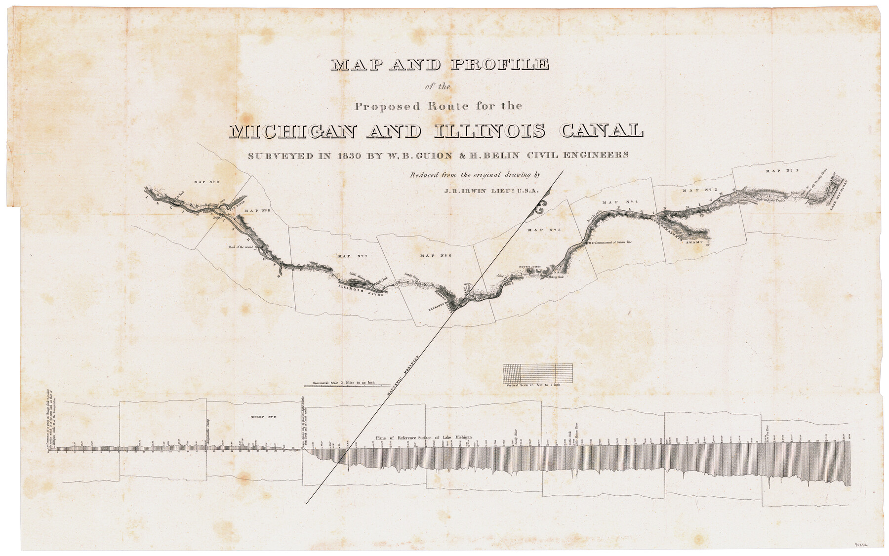
Map and Profile of the Proposed Route for the Michigan and Illinois Canal
-
Map/Doc
95692
-
Collection
General Map Collection
-
Object Dates
1830 (Creation Date)
-
People and Organizations
W.B. Guion (Surveyor/Engineer)
H. Belin (Surveyor/Engineer)
J.R. Irwin (Draftsman)
-
Subjects
United States
-
Height x Width
22.0 x 35.1 inches
55.9 x 89.2 cm
-
Medium
paper, etching/engraving/lithograph
-
Scale
1" = 3 miles
-
Comments
Map originally bound in volume: "Reports of Committees, 23d Congress, 1st Session; Vol. 4 - Rep. 447 to 560"
Related maps
Reports of Committees, 23d Congress, 1st Session

Reports of Committees, 23d Congress, 1st Session
Size 9.2 x 6.0 inches
Map/Doc 95690
Part of: General Map Collection
Flight Mission No. CRC-2R, Frame 187, Chambers County

Print $20.00
- Digital $50.00
Flight Mission No. CRC-2R, Frame 187, Chambers County
1956
Size 18.6 x 22.4 inches
Map/Doc 84765
Liberty County Working Sketch 54

Print $20.00
- Digital $50.00
Liberty County Working Sketch 54
1962
Size 29.8 x 29.5 inches
Map/Doc 70514
Rio Grande Rectification Project, El Paso and Juarez Valley

Print $20.00
- Digital $50.00
Rio Grande Rectification Project, El Paso and Juarez Valley
1935
Size 10.8 x 29.6 inches
Map/Doc 60872
Webb County Rolled Sketch 59

Print $20.00
- Digital $50.00
Webb County Rolled Sketch 59
1947
Size 15.3 x 26.7 inches
Map/Doc 8210
Flight Mission No. DAG-17K, Frame 142, Matagorda County

Print $20.00
- Digital $50.00
Flight Mission No. DAG-17K, Frame 142, Matagorda County
1952
Size 16.4 x 16.3 inches
Map/Doc 86359
Culberson County Sketch File WJ1

Print $6.00
- Digital $50.00
Culberson County Sketch File WJ1
1927
Size 11.2 x 8.9 inches
Map/Doc 20154

San Patricio County Sketch File 52

Print $14.00
- Digital $50.00
San Patricio County Sketch File 52
1917
Size 11.3 x 8.7 inches
Map/Doc 36381
Runnels County Rolled Sketch 47

Print $40.00
- Digital $50.00
Runnels County Rolled Sketch 47
1954
Size 49.9 x 30.5 inches
Map/Doc 76167
Travis County

Print $40.00
- Digital $50.00
Travis County
1880
Size 59.4 x 68.7 inches
Map/Doc 16903
Reeves County Rolled Sketch 29

Print $20.00
- Digital $50.00
Reeves County Rolled Sketch 29
1986
Size 21.6 x 27.5 inches
Map/Doc 7498
Guadalupe County Sketch File 17

Print $4.00
- Digital $50.00
Guadalupe County Sketch File 17
1877
Size 10.2 x 8.5 inches
Map/Doc 24695
You may also like
Crane County Rolled Sketch 5

Print $20.00
- Digital $50.00
Crane County Rolled Sketch 5
1927
Size 38.4 x 45.7 inches
Map/Doc 8677
Hemphill County Sketch File 2

Print $8.00
- Digital $50.00
Hemphill County Sketch File 2
1900
Size 10.3 x 8.4 inches
Map/Doc 26281
Sterling County Rolled Sketch 32

Print $20.00
- Digital $50.00
Sterling County Rolled Sketch 32
Size 17.9 x 29.4 inches
Map/Doc 7856
Matagorda County Sketch File 41

Print $6.00
- Digital $50.00
Matagorda County Sketch File 41
Size 10.2 x 12.1 inches
Map/Doc 30832
Harris County Rolled Sketch 98

Print $20.00
- Digital $50.00
Harris County Rolled Sketch 98
1992
Size 27.1 x 39.5 inches
Map/Doc 6136
Bailey County Working Sketch 1

Print $20.00
- Digital $50.00
Bailey County Working Sketch 1
1920
Size 28.9 x 10.5 inches
Map/Doc 67588
[W. T. Brewer: M. McDonald, Ralph Gilpin, A. Vanhooser, John Baker, John R. Taylor Surveys]
![90959, [W. T. Brewer: M. McDonald, Ralph Gilpin, A. Vanhooser, John Baker, John R. Taylor Surveys], Twichell Survey Records](https://historictexasmaps.com/wmedia_w700/maps/90959-1.tif.jpg)
Print $2.00
- Digital $50.00
[W. T. Brewer: M. McDonald, Ralph Gilpin, A. Vanhooser, John Baker, John R. Taylor Surveys]
Size 9.1 x 11.2 inches
Map/Doc 90959
A Survey of Lake Champlain, including Lake George, Crown Point and St. John

Print $20.00
- Digital $50.00
A Survey of Lake Champlain, including Lake George, Crown Point and St. John
1762
Size 29.0 x 20.9 inches
Map/Doc 97404
Colorado County Working Sketch 35

Print $20.00
- Digital $50.00
Colorado County Working Sketch 35
Size 19.8 x 15.8 inches
Map/Doc 76065
Galveston County NRC Article 33.136 Sketch 34

Print $20.00
- Digital $50.00
Galveston County NRC Article 33.136 Sketch 34
2005
Size 24.5 x 18.5 inches
Map/Doc 83405
Zapata County Sketch File 2

Print $20.00
- Digital $50.00
Zapata County Sketch File 2
1875
Size 24.3 x 32.8 inches
Map/Doc 12718
Flight Mission No. BQR-9K, Frame 13, Brazoria County

Print $20.00
- Digital $50.00
Flight Mission No. BQR-9K, Frame 13, Brazoria County
1952
Size 19.0 x 22.6 inches
Map/Doc 84042