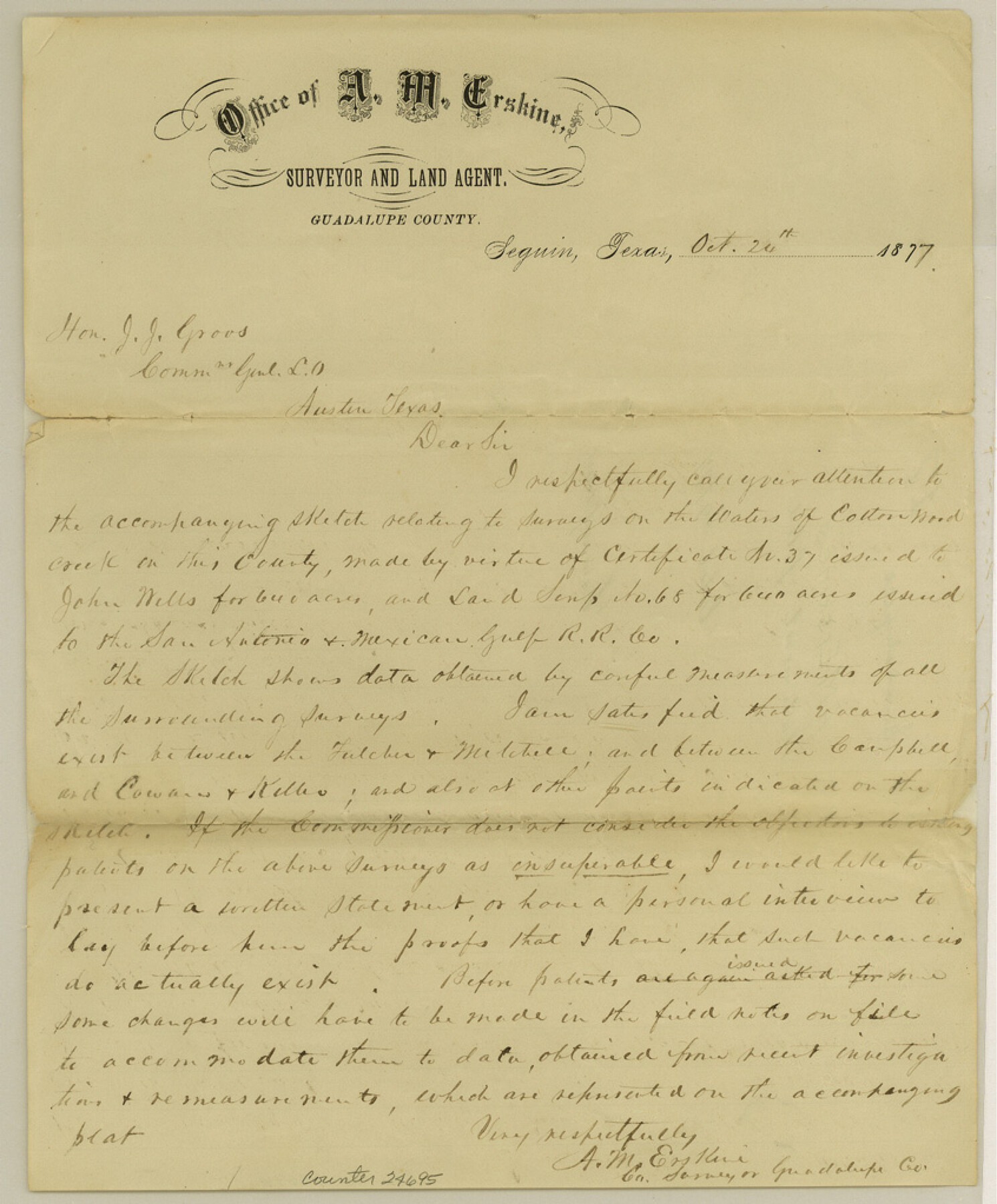
Guadalupe County Sketch File 17
[Letter accompanying sketch of surveys on waters of Cottonwood Creek]
-
Map/Doc
24695
-
Collection
General Map Collection
-
Object Dates
1877/10/20 (Creation Date)
1877/10/29 (File Date)
-
People and Organizations
A.M. Erskine (Surveyor/Engineer)
-
Counties
Guadalupe
-
Subjects
Surveying Sketch File
-
Height x Width
10.2 x 8.5 inches
25.9 x 21.6 cm
-
Medium
paper, manuscript
-
Features
Cottonwood Creek
Part of: General Map Collection
Flight Mission No. DQO-7K, Frame 111, Galveston County

Print $20.00
- Digital $50.00
Flight Mission No. DQO-7K, Frame 111, Galveston County
1952
Size 18.7 x 22.4 inches
Map/Doc 85126
Hamilton County

Print $20.00
- Digital $50.00
Hamilton County
1916
Size 41.4 x 40.5 inches
Map/Doc 66851
Edwards County Working Sketch 107

Print $40.00
- Digital $50.00
Edwards County Working Sketch 107
1972
Size 54.5 x 38.8 inches
Map/Doc 68983

Newton County Sketch File 48

Print $4.00
- Digital $50.00
Newton County Sketch File 48
Size 12.4 x 7.9 inches
Map/Doc 32460
Presidio County Sketch File P

Print $8.00
- Digital $50.00
Presidio County Sketch File P
1916
Size 14.4 x 8.8 inches
Map/Doc 34552
Titus County Working Sketch 3

Print $20.00
- Digital $50.00
Titus County Working Sketch 3
Size 21.7 x 31.8 inches
Map/Doc 69364
Aransas County Working Sketch 13

Print $20.00
- Digital $50.00
Aransas County Working Sketch 13
1950
Size 26.0 x 42.2 inches
Map/Doc 67180
Liberty County Rolled Sketch 2S

Print $20.00
- Digital $50.00
Liberty County Rolled Sketch 2S
1958
Size 32.0 x 40.6 inches
Map/Doc 10660
Starr County Boundary File 99

Print $56.00
- Digital $50.00
Starr County Boundary File 99
Size 9.2 x 6.2 inches
Map/Doc 58846
Zavala County Working Sketch 1

Print $20.00
- Digital $50.00
Zavala County Working Sketch 1
Size 21.2 x 16.3 inches
Map/Doc 62076
Knox County Sketch File 24

Print $6.00
- Digital $50.00
Knox County Sketch File 24
1945
Size 14.2 x 9.0 inches
Map/Doc 29254
You may also like
Flight Mission No. DAG-21K, Frame 85, Matagorda County

Print $20.00
- Digital $50.00
Flight Mission No. DAG-21K, Frame 85, Matagorda County
1952
Size 18.5 x 22.3 inches
Map/Doc 86414
Flight Mission No. BRA-16M, Frame 163, Jefferson County

Print $20.00
- Digital $50.00
Flight Mission No. BRA-16M, Frame 163, Jefferson County
1953
Size 18.6 x 22.3 inches
Map/Doc 85761
Dallam County Working Sketch 4

Print $20.00
- Digital $50.00
Dallam County Working Sketch 4
1974
Size 31.2 x 32.0 inches
Map/Doc 68589
Hudspeth County Rolled Sketch 73

Print $40.00
- Digital $50.00
Hudspeth County Rolled Sketch 73
1992
Size 38.9 x 49.3 inches
Map/Doc 9236

Tyler County Working Sketch 14

Print $20.00
- Digital $50.00
Tyler County Working Sketch 14
1959
Size 24.8 x 30.9 inches
Map/Doc 69484
Wood County Sketch File 10

Print $12.00
- Digital $50.00
Wood County Sketch File 10
1850
Size 8.3 x 12.8 inches
Map/Doc 40658
Missouri, Kansas, & Texas Ry.

Print $20.00
- Digital $50.00
Missouri, Kansas, & Texas Ry.
Size 6.7 x 5.4 inches
Map/Doc 96598
[Movements & Objectives of the 143rd & 144th Infantry on October 13, 1918, Appendix L]
![94124, [Movements & Objectives of the 143rd & 144th Infantry on October 13, 1918, Appendix L], Non-GLO Digital Images](https://historictexasmaps.com/wmedia_w700/maps/94124-1.tif.jpg)
Print $20.00
[Movements & Objectives of the 143rd & 144th Infantry on October 13, 1918, Appendix L]
1918
Size 16.1 x 16.8 inches
Map/Doc 94124
Hidalgo County Sketch File 10

Print $20.00
- Digital $50.00
Hidalgo County Sketch File 10
1911
Size 16.3 x 34.8 inches
Map/Doc 11762
Hardin County Rolled Sketch 13

Print $20.00
- Digital $50.00
Hardin County Rolled Sketch 13
1950
Size 29.8 x 27.4 inches
Map/Doc 9188
Map of Texas Showing County Names Only

Print $20.00
- Digital $50.00
Map of Texas Showing County Names Only
Size 34.2 x 43.6 inches
Map/Doc 2163