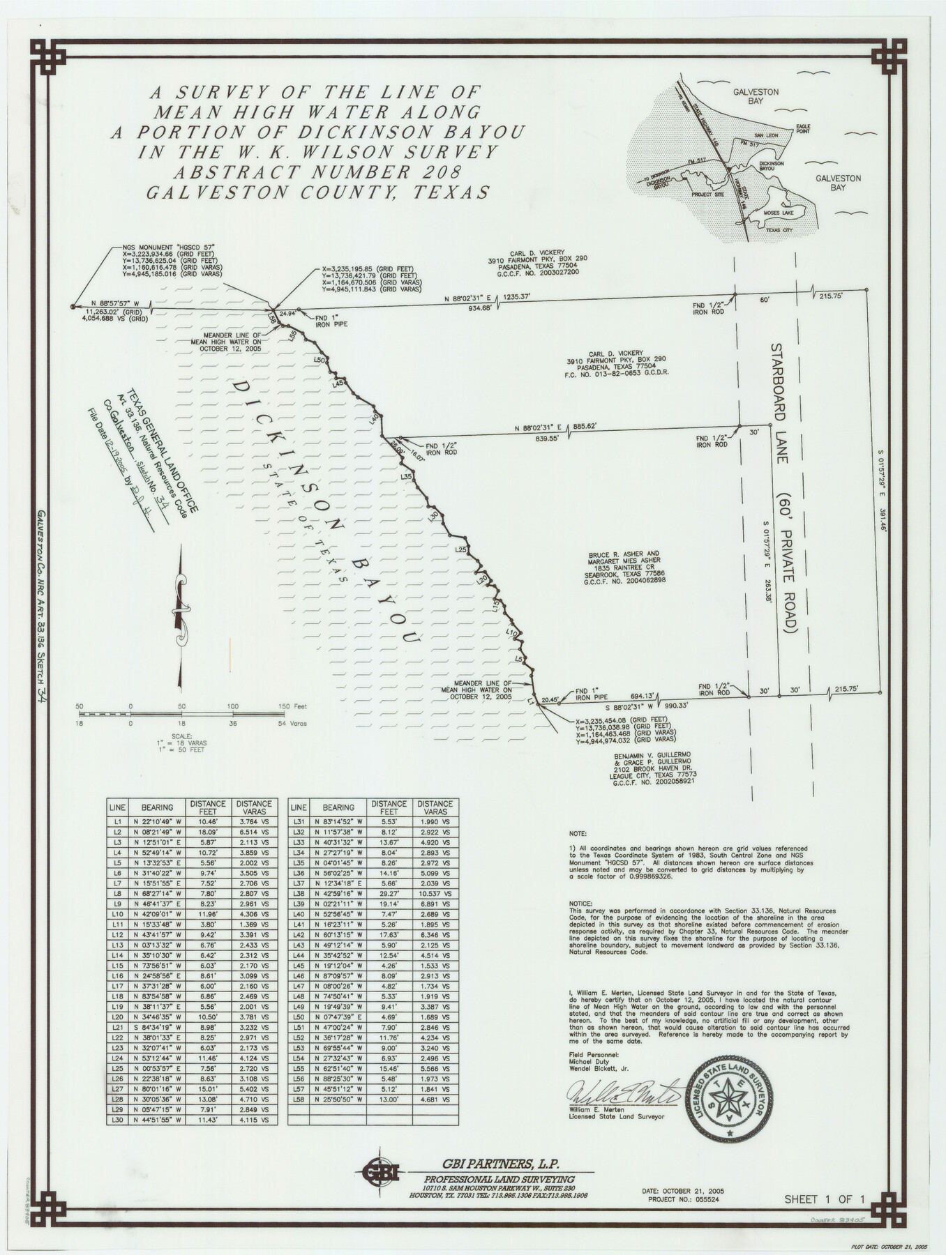
Galveston County NRC Article 33.136 Sketch 34
A Survey of the Line of Mean High Water along a Portion of Dickinson Bayou in the W. K. Wilson Survey Abstract 208
-
Map/Doc
83405
-
Collection
General Map Collection
-
Object Dates
2005/10/21 (Creation Date)
2005/12/19 (File Date)
-
People and Organizations
GBI Partners, L. P. (Publisher)
GBI Partners, L. P. (Printer)
William E. Merten (Surveyor/Engineer)
-
Counties
Galveston
-
Subjects
Surveying CBS
-
Height x Width
24.5 x 18.5 inches
62.2 x 47.0 cm
-
Medium
mylar, print
-
Comments
Survey located about 17 1/2 miles North 50 degrees West of Galveston, Texas.
Part of: General Map Collection
Sketch H Showing the progress of the Survey in Section No. 8

Print $20.00
- Digital $50.00
Sketch H Showing the progress of the Survey in Section No. 8
1846
Size 17.1 x 20.6 inches
Map/Doc 97222
Cameron County Rolled Sketch 30

Print $20.00
- Digital $50.00
Cameron County Rolled Sketch 30
1930
Size 36.3 x 24.4 inches
Map/Doc 5394
Val Verde County Rolled Sketch 69

Print $40.00
- Digital $50.00
Val Verde County Rolled Sketch 69
1942
Size 72.5 x 20.0 inches
Map/Doc 9805
Collin County Working Sketch 6

Print $20.00
- Digital $50.00
Collin County Working Sketch 6
1996
Size 11.2 x 42.2 inches
Map/Doc 68100
Hale County Working Sketch 6

Print $40.00
- Digital $50.00
Hale County Working Sketch 6
1963
Size 68.9 x 38.8 inches
Map/Doc 63326
Red River, Bois D'Arc Creek Floodway Sheet No. 7

Print $20.00
- Digital $50.00
Red River, Bois D'Arc Creek Floodway Sheet No. 7
1917
Size 29.0 x 23.8 inches
Map/Doc 69662
Hall County Rolled Sketch 3

Print $20.00
- Digital $50.00
Hall County Rolled Sketch 3
1890
Size 12.6 x 22.6 inches
Map/Doc 6048
Roberts County Working Sketch 23

Print $20.00
- Digital $50.00
Roberts County Working Sketch 23
1979
Size 19.7 x 12.9 inches
Map/Doc 63549
Montgomery County Working Sketch 15

Print $40.00
- Digital $50.00
Montgomery County Working Sketch 15
1934
Size 51.8 x 41.6 inches
Map/Doc 71122
Karnes County Rolled Sketch 3

Print $20.00
- Digital $50.00
Karnes County Rolled Sketch 3
1959
Size 27.9 x 41.6 inches
Map/Doc 6454
Brazoria County Aerial Photograph Index Sheet 6

Print $20.00
- Digital $50.00
Brazoria County Aerial Photograph Index Sheet 6
1953
Size 23.8 x 19.3 inches
Map/Doc 83668
Dimmit County Sketch File 59

Print $26.00
- Digital $50.00
Dimmit County Sketch File 59
1912
Size 14.4 x 8.9 inches
Map/Doc 21193
You may also like
Rockwall County Sketch File 5

Print $6.00
Rockwall County Sketch File 5
1861
Size 13.0 x 8.3 inches
Map/Doc 35422
Crane County Working Sketch 14

Print $20.00
- Digital $50.00
Crane County Working Sketch 14
1946
Size 16.0 x 22.3 inches
Map/Doc 68291
Van Zandt County Working Sketch 15

Print $20.00
- Digital $50.00
Van Zandt County Working Sketch 15
1982
Size 30.9 x 39.0 inches
Map/Doc 72265
Zavala County Rolled Sketch 32

Print $20.00
- Digital $50.00
Zavala County Rolled Sketch 32
Size 22.5 x 38.2 inches
Map/Doc 8333
Atascosa County Sketch File 36

Print $20.00
- Digital $50.00
Atascosa County Sketch File 36
1947
Size 16.0 x 22.3 inches
Map/Doc 10867
Sketch of coast of Texas, Laguna Madre from Pt. of Rocks to Corpus Christi [and accompanying letter]
![72963, Sketch of coast of Texas, Laguna Madre from Pt. of Rocks to Corpus Christi [and accompanying letter], General Map Collection](https://historictexasmaps.com/wmedia_w700/maps/72963.tif.jpg)
Print $2.00
- Digital $50.00
Sketch of coast of Texas, Laguna Madre from Pt. of Rocks to Corpus Christi [and accompanying letter]
1882
Size 11.2 x 8.8 inches
Map/Doc 72963
Potter County Rolled Sketch 13

Print $20.00
- Digital $50.00
Potter County Rolled Sketch 13
2004
Size 18.7 x 23.2 inches
Map/Doc 82477
Kendall County Sketch File 17

Print $4.00
- Digital $50.00
Kendall County Sketch File 17
1878
Size 9.1 x 7.6 inches
Map/Doc 28709
Crockett County Working Sketch 31

Print $20.00
- Digital $50.00
Crockett County Working Sketch 31
1924
Size 37.2 x 33.5 inches
Map/Doc 68364
[Map Showing Estivan Martinez "Los Nerios de Tio Ayola" Survey and Surveys North Thereof, Brooks County, Texas]
![10755, [Map Showing Estivan Martinez "Los Nerios de Tio Ayola" Survey and Surveys North Thereof, Brooks County, Texas], Maddox Collection](https://historictexasmaps.com/wmedia_w700/maps/10755.tif.jpg)
Print $20.00
- Digital $50.00
[Map Showing Estivan Martinez "Los Nerios de Tio Ayola" Survey and Surveys North Thereof, Brooks County, Texas]
1906
Size 16.7 x 25.1 inches
Map/Doc 10755
Kleberg County Rolled Sketch 10-2

Print $20.00
- Digital $50.00
Kleberg County Rolled Sketch 10-2
1951
Size 36.5 x 33.4 inches
Map/Doc 9377
Hunt County Rolled Sketch 5

Print $20.00
- Digital $50.00
Hunt County Rolled Sketch 5
1956
Size 27.6 x 24.8 inches
Map/Doc 6270