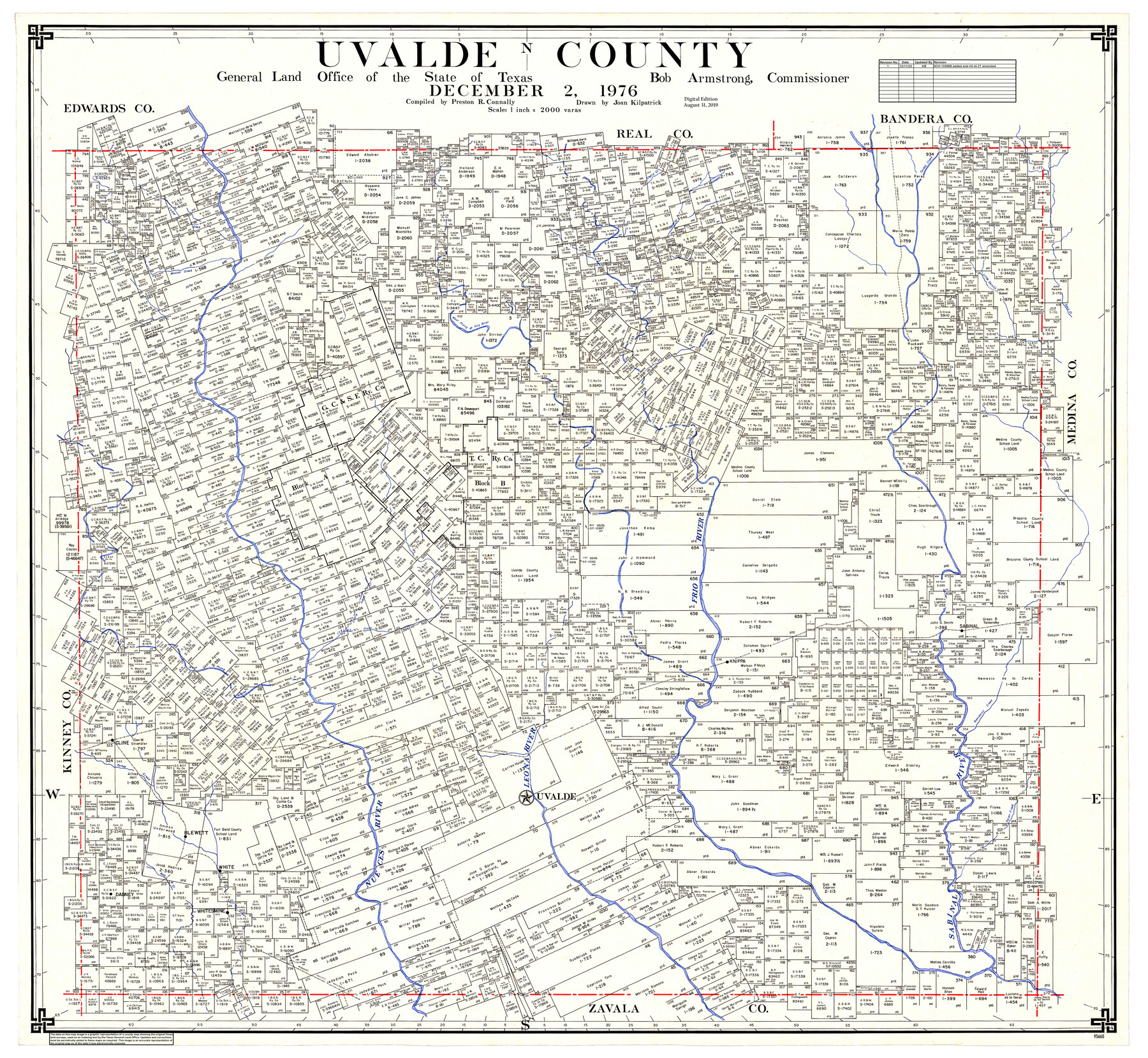
Uvalde County
General Land Office Official County Map
-
Map/Doc
95660
-
Collection
General Map Collection
-
Object Dates
12/2/1976 (Creation Date)
8/31/2019 (Revision Date)
12/11/2023 (Revision Date)
-
People and Organizations
Joan Kilpatrick (Draftsman)
Preston R. Connally (Compiler)
Bob Armstrong (GLO Commissioner)
Cheyenne Betancourt (Draftsman)
Kat Bird (Draftsman)
-
Counties
Uvalde
-
Subjects
County OCM
-
Height x Width
43.0 x 46.3 inches
109.2 x 117.6 cm
-
Medium
digital image
-
Scale
1" = 2000 varas
Part of: General Map Collection
Webb County Working Sketch 19

Print $20.00
- Digital $50.00
Webb County Working Sketch 19
1925
Size 32.6 x 29.8 inches
Map/Doc 72384
Menard County Boundary File 11

Print $2.00
- Digital $50.00
Menard County Boundary File 11
Size 11.2 x 8.7 inches
Map/Doc 57098
San Patricio County Rolled Sketch 29B

Print $20.00
- Digital $50.00
San Patricio County Rolled Sketch 29B
1936
Size 25.8 x 31.0 inches
Map/Doc 7582
Young County Sketch File 10

Print $20.00
- Digital $50.00
Young County Sketch File 10
Size 14.1 x 17.7 inches
Map/Doc 12711
Leon County Working Sketch 22

Print $20.00
- Digital $50.00
Leon County Working Sketch 22
1965
Size 27.9 x 31.1 inches
Map/Doc 70421
Coleman County Sketch File 27

Print $4.00
- Digital $50.00
Coleman County Sketch File 27
1873
Size 12.8 x 8.0 inches
Map/Doc 18714
Crockett County Rolled Sketch 49

Print $20.00
- Digital $50.00
Crockett County Rolled Sketch 49
1940
Size 32.8 x 42.7 inches
Map/Doc 8713
Lynn County Boundary File 7

Print $10.00
- Digital $50.00
Lynn County Boundary File 7
Size 11.5 x 8.8 inches
Map/Doc 56642
Flight Mission No. DQN-2K, Frame 37, Calhoun County

Print $20.00
- Digital $50.00
Flight Mission No. DQN-2K, Frame 37, Calhoun County
1953
Size 18.4 x 22.2 inches
Map/Doc 84242
Carte Geo-Hydrographique du Golfe du Mexique et de ses Isles construite d'après les mémoires les plus recens, et assujeties, pour l'emplacement de ces principales positions aux latitudes et longitudes

Print $20.00
- Digital $50.00
Carte Geo-Hydrographique du Golfe du Mexique et de ses Isles construite d'après les mémoires les plus recens, et assujeties, pour l'emplacement de ces principales positions aux latitudes et longitudes
1771
Size 15.0 x 20.5 inches
Map/Doc 94108
Mason County Sketch File 16

Print $5.00
- Digital $50.00
Mason County Sketch File 16
Size 9.1 x 11.2 inches
Map/Doc 30703
Somervell County Working Sketch 1

Print $20.00
- Digital $50.00
Somervell County Working Sketch 1
1950
Size 17.8 x 15.4 inches
Map/Doc 63905
You may also like
General Highway Map, Young County, Texas

Print $20.00
General Highway Map, Young County, Texas
1940
Size 18.4 x 24.8 inches
Map/Doc 79286
Uvalde County Rolled Sketch B

Print $20.00
- Digital $50.00
Uvalde County Rolled Sketch B
1847
Size 28.8 x 22.4 inches
Map/Doc 8105
Orange County Working Sketch 54b

Print $40.00
- Digital $50.00
Orange County Working Sketch 54b
2008
Size 38.0 x 50.3 inches
Map/Doc 88743
Wharton County Rolled Sketch 5

Print $20.00
- Digital $50.00
Wharton County Rolled Sketch 5
1899
Size 19.3 x 24.6 inches
Map/Doc 8229
Atlantic Coast to the Rocky Mountains

Atlantic Coast to the Rocky Mountains
1956
Size 42.5 x 29.4 inches
Map/Doc 94409
Cameron County Rolled Sketch 25

Print $40.00
- Digital $50.00
Cameron County Rolled Sketch 25
1977
Size 25.0 x 72.9 inches
Map/Doc 5791
Cameron County Rolled Sketch 15

Print $40.00
- Digital $50.00
Cameron County Rolled Sketch 15
1958
Size 53.0 x 32.0 inches
Map/Doc 8568
[Sketch showing Blocks M-20 and M-22]
![91722, [Sketch showing Blocks M-20 and M-22], Twichell Survey Records](https://historictexasmaps.com/wmedia_w700/maps/91722-1.tif.jpg)
Print $20.00
- Digital $50.00
[Sketch showing Blocks M-20 and M-22]
Size 15.0 x 19.5 inches
Map/Doc 91722
Texas - Rand McNally Indexed Pocket Map - Tourists' and Shippers' Guide - Main Highways, Railroads, and Electric Lines, Counties, Cities, Towns, Villages, Post Offices, Lakes, Rivers, etc.

Texas - Rand McNally Indexed Pocket Map - Tourists' and Shippers' Guide - Main Highways, Railroads, and Electric Lines, Counties, Cities, Towns, Villages, Post Offices, Lakes, Rivers, etc.
1924
Map/Doc 95854
Rusk County Sketch File 40

Print $20.00
Rusk County Sketch File 40
1951
Size 23.2 x 26.6 inches
Map/Doc 12276
The Republic County of San Patricio. 1840

Print $20.00
The Republic County of San Patricio. 1840
2020
Size 22.2 x 21.7 inches
Map/Doc 96276
Coast Chart No. 210 Aransas Pass and Corpus Christi Bay with the coast to latitude 27° 12' Texas

Print $20.00
- Digital $50.00
Coast Chart No. 210 Aransas Pass and Corpus Christi Bay with the coast to latitude 27° 12' Texas
1913
Size 27.6 x 18.2 inches
Map/Doc 72807