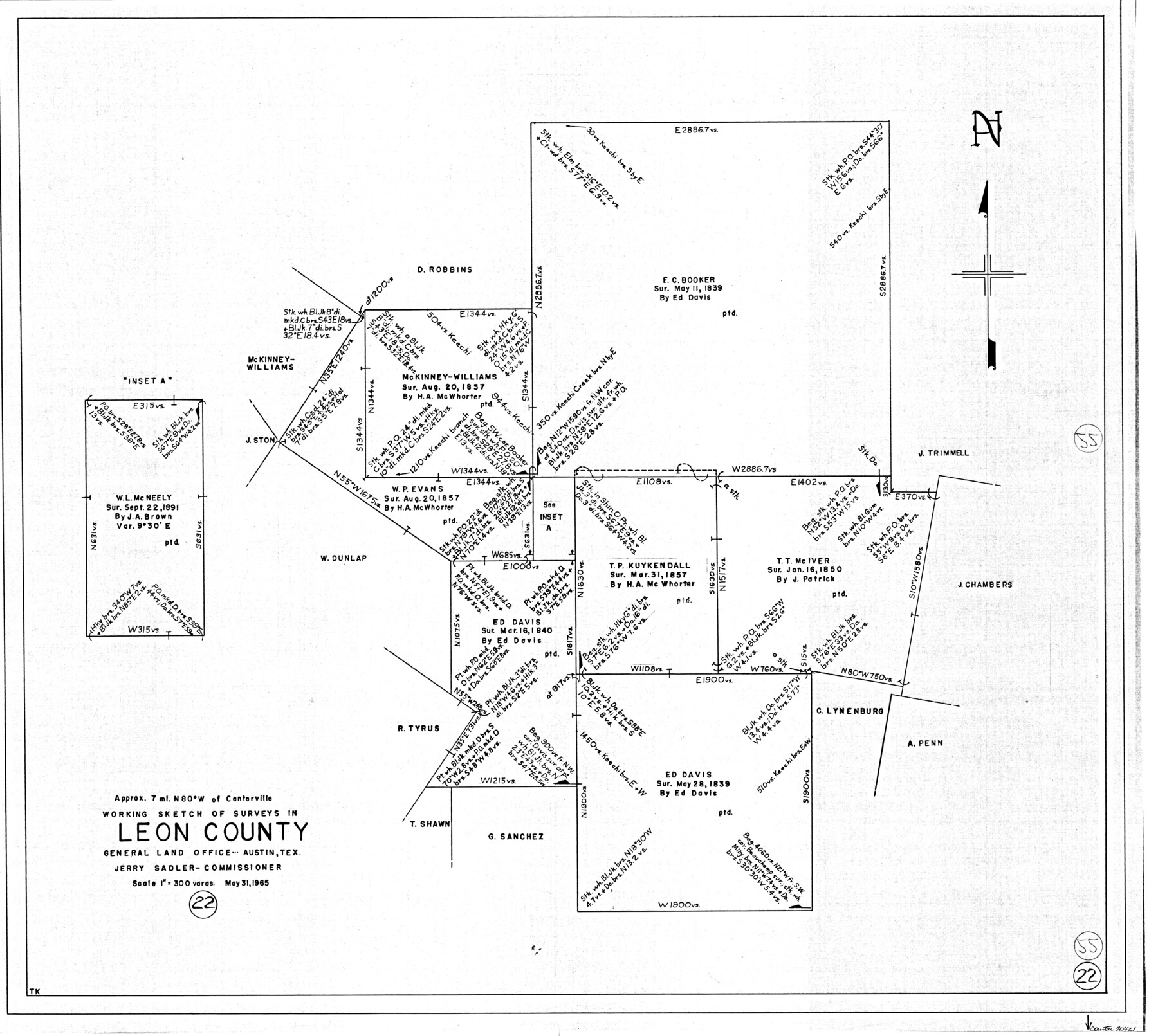
Leon County Working Sketch 22
-
Map/Doc
70421
-
Collection
General Map Collection
-
Object Dates
5/31/1965 (Creation Date)
-
Counties
Leon
-
Subjects
Surveying Working Sketch
-
Height x Width
27.9 x 31.1 inches
70.9 x 79.0 cm
-
Scale
1" = 300 varas
Part of: General Map Collection
Flight Mission No. BRE-2P, Frame 42, Nueces County

Print $20.00
- Digital $50.00
Flight Mission No. BRE-2P, Frame 42, Nueces County
1956
Size 18.5 x 22.4 inches
Map/Doc 86744

Pecos County Rolled Sketch 39A

Print $20.00
- Digital $50.00
Pecos County Rolled Sketch 39A
1908
Size 23.8 x 35.9 inches
Map/Doc 7218
Cooke County Sketch File 32

Print $43.00
- Digital $50.00
Cooke County Sketch File 32
1873
Size 11.1 x 17.6 inches
Map/Doc 19295
Flight Mission No. DCL-7C, Frame 61, Kenedy County

Print $20.00
- Digital $50.00
Flight Mission No. DCL-7C, Frame 61, Kenedy County
1943
Size 15.4 x 15.2 inches
Map/Doc 86049
Martin County Working Sketch 10

Print $40.00
- Digital $50.00
Martin County Working Sketch 10
1971
Size 50.0 x 37.4 inches
Map/Doc 70828
Liberty County Rolled Sketch 15

Print $20.00
- Digital $50.00
Liberty County Rolled Sketch 15
2015
Size 36.1 x 24.3 inches
Map/Doc 94022
Uvalde County Working Sketch 51

Print $20.00
- Digital $50.00
Uvalde County Working Sketch 51
1981
Size 34.7 x 37.7 inches
Map/Doc 72121
Colorado River, Carancahua Sheet

Print $20.00
- Digital $50.00
Colorado River, Carancahua Sheet
1940
Size 30.7 x 38.0 inches
Map/Doc 65320
[Bastrop District]
![16941, [Bastrop District], General Map Collection](https://historictexasmaps.com/wmedia_w700/maps/16941-1.tif.jpg)
Print $40.00
- Digital $50.00
[Bastrop District]
1838
Size 67.3 x 44.2 inches
Map/Doc 16941
Harris County Working Sketch 84

Print $20.00
- Digital $50.00
Harris County Working Sketch 84
1970
Size 36.2 x 33.7 inches
Map/Doc 65976
United States - Gulf Coast - Aransas Pass and Corpus Christi Bay with the coast to latitude 27° 12' Texas

Print $20.00
- Digital $50.00
United States - Gulf Coast - Aransas Pass and Corpus Christi Bay with the coast to latitude 27° 12' Texas
1913
Size 27.6 x 18.2 inches
Map/Doc 72793
You may also like
Sketch of North Line of T&P Eighty Mile Reserve

Print $20.00
- Digital $50.00
Sketch of North Line of T&P Eighty Mile Reserve
1914
Size 43.0 x 9.8 inches
Map/Doc 2245
Galveston County Rolled Sketch 27A

Print $20.00
- Digital $50.00
Galveston County Rolled Sketch 27A
1978
Size 32.2 x 35.5 inches
Map/Doc 5962
Flight Mission No. DQO-7K, Frame 103, Galveston County

Print $20.00
- Digital $50.00
Flight Mission No. DQO-7K, Frame 103, Galveston County
1952
Size 18.5 x 22.7 inches
Map/Doc 85118
Missouri, Kansas & Texas Ry. thro' Denison and the beautiful Indian Territory

Print $20.00
- Digital $50.00
Missouri, Kansas & Texas Ry. thro' Denison and the beautiful Indian Territory
1877
Size 15.7 x 21.7 inches
Map/Doc 95805
Val Verde County Rolled Sketch 86

Print $20.00
- Digital $50.00
Val Verde County Rolled Sketch 86
2014
Size 11.9 x 18.4 inches
Map/Doc 93690
Gregg County Working Sketch 5

Print $20.00
- Digital $50.00
Gregg County Working Sketch 5
1933
Size 18.0 x 42.6 inches
Map/Doc 63271
Anderson County Rolled Sketch 13

Print $20.00
- Digital $50.00
Anderson County Rolled Sketch 13
1964
Size 19.8 x 32.2 inches
Map/Doc 77158
Atascosa County Working Sketch 4

Print $20.00
- Digital $50.00
Atascosa County Working Sketch 4
1913
Size 16.8 x 15.0 inches
Map/Doc 67199
Flight Mission No. DAG-21K, Frame 42, Matagorda County

Print $20.00
- Digital $50.00
Flight Mission No. DAG-21K, Frame 42, Matagorda County
1952
Size 18.7 x 22.4 inches
Map/Doc 86409
Jack County Boundary File 3

Print $10.00
- Digital $50.00
Jack County Boundary File 3
Size 9.2 x 4.0 inches
Map/Doc 55408
Throckmorton County Working Sketch 10

Print $20.00
- Digital $50.00
Throckmorton County Working Sketch 10
1986
Size 22.8 x 36.8 inches
Map/Doc 62119
[Sketch of Leagues 458, 459, 474, 475, 480 and 481]
![91547, [Sketch of Leagues 458, 459, 474, 475, 480 and 481], Twichell Survey Records](https://historictexasmaps.com/wmedia_w700/maps/91547-1.tif.jpg)
Print $2.00
- Digital $50.00
[Sketch of Leagues 458, 459, 474, 475, 480 and 481]
Size 5.2 x 8.3 inches
Map/Doc 91547