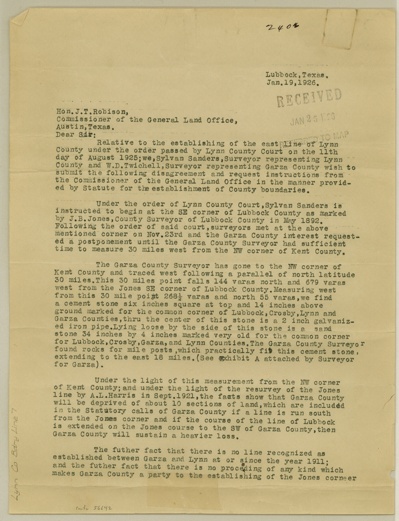
Lynn County Boundary File 7
[Statement of County Judge on Lynn-Garza Boundary line; Statement of disagreement on Lynn-Garza Boundary line]
-
Map/Doc
56642
-
Collection
General Map Collection
-
Counties
Lynn
-
Subjects
County Boundaries
-
Height x Width
11.5 x 8.8 inches
29.2 x 22.4 cm
Part of: General Map Collection
Hutchinson County Working Sketch 43

Print $20.00
- Digital $50.00
Hutchinson County Working Sketch 43
1978
Size 26.6 x 22.3 inches
Map/Doc 66403
Harrison County Working Sketch 15

Print $20.00
- Digital $50.00
Harrison County Working Sketch 15
1961
Size 25.7 x 18.0 inches
Map/Doc 66035
Flight Mission No. BRA-16M, Frame 180, Jefferson County

Print $20.00
- Digital $50.00
Flight Mission No. BRA-16M, Frame 180, Jefferson County
1953
Size 18.5 x 22.4 inches
Map/Doc 85778
Gillespie County Boundary File 4

Print $56.00
- Digital $50.00
Gillespie County Boundary File 4
Size 13.6 x 9.0 inches
Map/Doc 53754
Jeff Davis County Working Sketch 9

Print $20.00
- Digital $50.00
Jeff Davis County Working Sketch 9
1943
Size 28.5 x 27.3 inches
Map/Doc 66504
Hudspeth County Working Sketch 53-2

Print $40.00
- Digital $50.00
Hudspeth County Working Sketch 53-2
1988
Size 49.9 x 43.3 inches
Map/Doc 78210
Map Showing Survey of Navasota River Bed in Limestone County Texas Located North of Houston and Texas Central Railroad Bridge

Print $20.00
- Digital $50.00
Map Showing Survey of Navasota River Bed in Limestone County Texas Located North of Houston and Texas Central Railroad Bridge
1921
Size 45.8 x 38.5 inches
Map/Doc 65348
Brewster County Sketch File FN-30

Print $4.00
- Digital $50.00
Brewster County Sketch File FN-30
1975
Size 12.0 x 8.7 inches
Map/Doc 15850
Flight Mission No. CUG-1P, Frame 112, Kleberg County

Print $20.00
- Digital $50.00
Flight Mission No. CUG-1P, Frame 112, Kleberg County
1956
Size 18.5 x 22.3 inches
Map/Doc 86162
Cameron County Boundary File 5

Print $8.00
- Digital $50.00
Cameron County Boundary File 5
Size 8.8 x 15.3 inches
Map/Doc 51113
Intracoastal Waterway in Texas - Corpus Christi to Point Isabel including Arroyo Colorado to Mo. Pac. R.R. Bridge Near Harlingen

Print $20.00
- Digital $50.00
Intracoastal Waterway in Texas - Corpus Christi to Point Isabel including Arroyo Colorado to Mo. Pac. R.R. Bridge Near Harlingen
1933
Size 28.0 x 41.0 inches
Map/Doc 61875
Newton County Rolled Sketch 14

Print $40.00
- Digital $50.00
Newton County Rolled Sketch 14
1953
Size 33.4 x 56.0 inches
Map/Doc 9579
You may also like
[Surveys in Austin's Colony along the Brazos River]
![164, [Surveys in Austin's Colony along the Brazos River], General Map Collection](https://historictexasmaps.com/wmedia_w700/maps/164.tif.jpg)
Print $20.00
- Digital $50.00
[Surveys in Austin's Colony along the Brazos River]
1833
Size 25.0 x 23.9 inches
Map/Doc 164
Brewster County Sketch File 40

Print $6.00
- Digital $50.00
Brewster County Sketch File 40
1910
Size 15.2 x 10.3 inches
Map/Doc 16302
Tarrant County

Print $20.00
- Digital $50.00
Tarrant County
1857
Size 20.9 x 15.4 inches
Map/Doc 4628
Flight Mission No. CUG-1P, Frame 81, Kleberg County

Print $20.00
- Digital $50.00
Flight Mission No. CUG-1P, Frame 81, Kleberg County
1956
Size 18.5 x 22.2 inches
Map/Doc 86146
Working Sketch in McMullen County

Print $3.00
- Digital $50.00
Working Sketch in McMullen County
1883
Size 11.7 x 12.1 inches
Map/Doc 576
Flight Mission No. BQR-4K, Frame 69, Brazoria County

Print $20.00
- Digital $50.00
Flight Mission No. BQR-4K, Frame 69, Brazoria County
1952
Size 18.7 x 22.4 inches
Map/Doc 84002
Coast Chart No. 212 - From Latitude 26° 33' to the Rio Grande, Texas

Print $20.00
- Digital $50.00
Coast Chart No. 212 - From Latitude 26° 33' to the Rio Grande, Texas
1886
Size 37.8 x 34.1 inches
Map/Doc 73503
Galveston County Sketch File 9

Print $6.00
- Digital $50.00
Galveston County Sketch File 9
1866
Size 10.1 x 8.1 inches
Map/Doc 23369
Map of Navisota County

Print $20.00
- Digital $50.00
Map of Navisota County
Size 27.5 x 19.6 inches
Map/Doc 3328
[Report showing connections and corners made on ground in south part of Yoakum County and north part of Gaines County, Texas]

[Report showing connections and corners made on ground in south part of Yoakum County and north part of Gaines County, Texas]
1938
Size 8.1 x 10.9 inches
Map/Doc 93256
Section 40, Block Y

Print $20.00
- Digital $50.00
Section 40, Block Y
Size 23.9 x 19.5 inches
Map/Doc 92460
Flight Mission No. DQN-1K, Frame 35, Calhoun County

Print $20.00
- Digital $50.00
Flight Mission No. DQN-1K, Frame 35, Calhoun County
1953
Size 18.5 x 19.0 inches
Map/Doc 84140