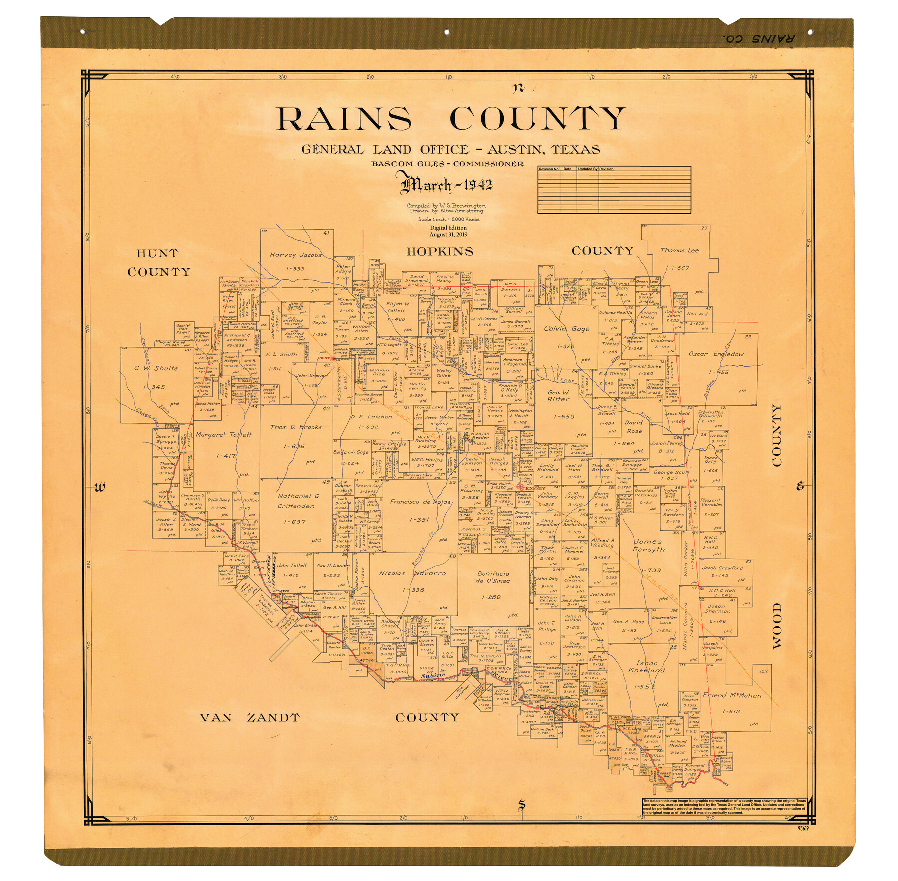
Rains County
General Land Office Official County Map
-
Map/Doc
95619
-
Collection
General Map Collection
-
Object Dates
2019/8/31 (Revision Date)
1942 (Creation Date)
-
People and Organizations
Cheyenne Betancourt (Draftsman)
Eltea Armstrong (Draftsman)
W. S. Brewington (Compiler)
Bascom Giles (GLO Commissioner)
-
Counties
Rains
-
Subjects
County OCM
-
Height x Width
30.2 x 30.8 inches
76.7 x 78.2 cm
-
Medium
digital image
-
Scale
1" = 2000 varas
Part of: General Map Collection
[Pacific & Santa Fe Railroad through Fort Stockton]
![64770, [Pacific & Santa Fe Railroad through Fort Stockton], General Map Collection](https://historictexasmaps.com/wmedia_w700/maps/64770.tif.jpg)
Print $20.00
- Digital $50.00
[Pacific & Santa Fe Railroad through Fort Stockton]
Size 18.4 x 20.5 inches
Map/Doc 64770
Flight Mission No. BRA-16M, Frame 86, Jefferson County

Print $20.00
- Digital $50.00
Flight Mission No. BRA-16M, Frame 86, Jefferson County
1953
Size 18.5 x 22.3 inches
Map/Doc 85698
Blucher's Directory Map of Corpus Christi and Road Map of Nueces County

Print $20.00
- Digital $50.00
Blucher's Directory Map of Corpus Christi and Road Map of Nueces County
1945
Size 22.6 x 34.3 inches
Map/Doc 94106
Collin County Sketch File 3

Print $20.00
- Digital $50.00
Collin County Sketch File 3
1852
Size 19.5 x 21.4 inches
Map/Doc 11126
Map of Terry County

Print $20.00
- Digital $50.00
Map of Terry County
1901
Size 43.1 x 39.8 inches
Map/Doc 16892
Morris County Working Sketch Graphic Index

Print $20.00
- Digital $50.00
Morris County Working Sketch Graphic Index
1948
Size 42.8 x 20.1 inches
Map/Doc 76649
Right of Way and Track Map, the Missouri, Kansas and Texas Ry. of Texas operated by the Missouri, Kansas and Texas Ry. of Texas, San Antonio Division

Print $40.00
- Digital $50.00
Right of Way and Track Map, the Missouri, Kansas and Texas Ry. of Texas operated by the Missouri, Kansas and Texas Ry. of Texas, San Antonio Division
1918
Size 25.6 x 57.8 inches
Map/Doc 64582
Nueces County Sketch File 53

Print $4.00
- Digital $50.00
Nueces County Sketch File 53
1903
Size 11.1 x 8.8 inches
Map/Doc 32863
Flight Mission No. DIX-5P, Frame 138, Aransas County

Print $20.00
- Digital $50.00
Flight Mission No. DIX-5P, Frame 138, Aransas County
1956
Size 17.7 x 17.9 inches
Map/Doc 83799
Leon County Working Sketch 14

Print $40.00
- Digital $50.00
Leon County Working Sketch 14
1956
Size 48.8 x 34.5 inches
Map/Doc 70413

Bowie County Sketch File 7a

Print $30.00
- Digital $50.00
Bowie County Sketch File 7a
1927
Size 11.2 x 8.7 inches
Map/Doc 14854
You may also like
San Jacinto County Working Sketch Graphic Index

Print $20.00
- Digital $50.00
San Jacinto County Working Sketch Graphic Index
1942
Size 44.9 x 40.6 inches
Map/Doc 76691
Morris County Rolled Sketch 2A

Print $20.00
- Digital $50.00
Morris County Rolled Sketch 2A
Size 24.4 x 19.4 inches
Map/Doc 10245
Railroad and County Map of Texas

Print $20.00
- Digital $50.00
Railroad and County Map of Texas
1926
Size 42.9 x 45.2 inches
Map/Doc 65799
Val Verde County Sketch File 41

Print $20.00
- Digital $50.00
Val Verde County Sketch File 41
1938
Size 17.8 x 22.7 inches
Map/Doc 12583
Chambers County Sketch File 40

Print $35.00
- Digital $50.00
Chambers County Sketch File 40
1925
Size 14.0 x 8.5 inches
Map/Doc 17677
General Highway Map, La Salle County, Texas

Print $20.00
General Highway Map, La Salle County, Texas
1961
Size 18.2 x 24.8 inches
Map/Doc 79565
[Blocks K-7, K-8, Leagues 443-446, 390, 392, 407-410]
![90543, [Blocks K-7, K-8, Leagues 443-446, 390, 392, 407-410], Twichell Survey Records](https://historictexasmaps.com/wmedia_w700/maps/90543-1.tif.jpg)
Print $3.00
- Digital $50.00
[Blocks K-7, K-8, Leagues 443-446, 390, 392, 407-410]
Size 10.4 x 14.2 inches
Map/Doc 90543
Caldwell County Sketch File 4a

Print $8.00
- Digital $50.00
Caldwell County Sketch File 4a
1898
Size 11.2 x 8.8 inches
Map/Doc 35835
Cooke County Working Sketch 32

Print $20.00
- Digital $50.00
Cooke County Working Sketch 32
1982
Size 19.0 x 14.8 inches
Map/Doc 68269
Flight Mission No. DCL-7C, Frame 31, Kenedy County

Print $20.00
- Digital $50.00
Flight Mission No. DCL-7C, Frame 31, Kenedy County
1943
Size 15.4 x 15.2 inches
Map/Doc 86023
Ector County Working Sketch 13

Print $40.00
- Digital $50.00
Ector County Working Sketch 13
1955
Size 71.8 x 43.5 inches
Map/Doc 68856
McMullen County Rolled Sketch 5

Print $20.00
- Digital $50.00
McMullen County Rolled Sketch 5
Size 46.4 x 26.8 inches
Map/Doc 6723