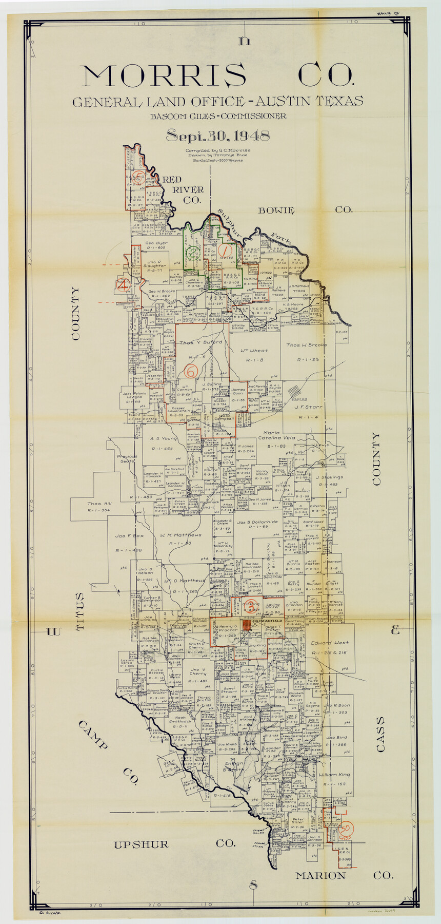
Morris County Working Sketch Graphic Index
-
Map/Doc
76649
-
Collection
General Map Collection
-
Object Dates
9/30/1948 (Creation Date)
-
People and Organizations
G.C. Morriss (Compiler)
Tommye Buie (Draftsman)
-
Counties
Morris
-
Subjects
County Surveying Working Sketch
-
Height x Width
42.8 x 20.1 inches
108.7 x 51.1 cm
-
Scale
1" = 2000 varas
Part of: General Map Collection
Cass County Sketch File 7

Print $4.00
- Digital $50.00
Cass County Sketch File 7
1853
Size 8.0 x 12.6 inches
Map/Doc 17408
Pecos County Rolled Sketch 19

Print $21.00
- Digital $50.00
Pecos County Rolled Sketch 19
1885
Size 9.4 x 14.7 inches
Map/Doc 48082
Red River County Working Sketch 79

Print $40.00
- Digital $50.00
Red River County Working Sketch 79
1986
Size 43.8 x 61.1 inches
Map/Doc 72062
El Paso County Boundary File 6

Print $14.00
- Digital $50.00
El Paso County Boundary File 6
Size 14.0 x 8.8 inches
Map/Doc 53080
Red River County Sketch File 23

Print $4.00
- Digital $50.00
Red River County Sketch File 23
1901
Size 11.3 x 8.8 inches
Map/Doc 35157
[Sketch for Mineral Application 16787 - Pecos River Bed, A. T. Freet]
![2816, [Sketch for Mineral Application 16787 - Pecos River Bed, A. T. Freet], General Map Collection](https://historictexasmaps.com/wmedia_w700/maps/2816-1.tif.jpg)
Print $20.00
- Digital $50.00
[Sketch for Mineral Application 16787 - Pecos River Bed, A. T. Freet]
1927
Size 18.4 x 32.7 inches
Map/Doc 2816
Navarro County Sketch File 6

Print $6.00
- Digital $50.00
Navarro County Sketch File 6
1849
Size 6.2 x 8.4 inches
Map/Doc 32310
New Oil and Geological Map of Texas showing Oil Fields, Pipe Lines, Refineries, Geological Formations, Etc.

Print $20.00
- Digital $50.00
New Oil and Geological Map of Texas showing Oil Fields, Pipe Lines, Refineries, Geological Formations, Etc.
1920
Size 22.5 x 31.3 inches
Map/Doc 96633
Padre Island National Seashore, Texas - Dependent Resurvey

Print $4.00
- Digital $50.00
Padre Island National Seashore, Texas - Dependent Resurvey
2001
Size 18.4 x 24.0 inches
Map/Doc 60551
San Saba County Working Sketch 6

Print $20.00
- Digital $50.00
San Saba County Working Sketch 6
1959
Size 17.5 x 23.4 inches
Map/Doc 63794
Flight Mission No. CRC-2R, Frame 118, Chambers County

Print $20.00
- Digital $50.00
Flight Mission No. CRC-2R, Frame 118, Chambers County
1956
Size 18.6 x 21.6 inches
Map/Doc 84742
McLennan County Sketch File 18

Print $8.00
- Digital $50.00
McLennan County Sketch File 18
1880
Size 12.8 x 8.3 inches
Map/Doc 31280
You may also like
Bowie County Sketch File 6c

Print $40.00
- Digital $50.00
Bowie County Sketch File 6c
1927
Size 20.1 x 16.1 inches
Map/Doc 10942
Sutton County Boundary File 6

Print $10.00
- Digital $50.00
Sutton County Boundary File 6
Size 14.4 x 8.8 inches
Map/Doc 59070
Andrews County Rolled Sketch 44

Print $40.00
- Digital $50.00
Andrews County Rolled Sketch 44
1990
Size 37.0 x 64.8 inches
Map/Doc 94990
Flight Mission No. CLL-1N, Frame 17, Willacy County

Print $20.00
- Digital $50.00
Flight Mission No. CLL-1N, Frame 17, Willacy County
1954
Size 18.5 x 22.1 inches
Map/Doc 87004
Brewster County Rolled Sketch 47

Print $20.00
- Digital $50.00
Brewster County Rolled Sketch 47
1930
Size 18.1 x 41.0 inches
Map/Doc 5223
Williamson County Sketch File 20

Print $4.00
- Digital $50.00
Williamson County Sketch File 20
Size 8.2 x 12.9 inches
Map/Doc 40348
Map of the City of Kerens (Navarro County) Texas

Print $40.00
- Digital $50.00
Map of the City of Kerens (Navarro County) Texas
1958
Size 44.2 x 54.9 inches
Map/Doc 93670
Williamson County Sketch File 1

Print $4.00
- Digital $50.00
Williamson County Sketch File 1
1847
Size 8.8 x 10.1 inches
Map/Doc 40299
Flight Mission No. BQY-4M, Frame 40, Harris County

Print $20.00
- Digital $50.00
Flight Mission No. BQY-4M, Frame 40, Harris County
1953
Size 18.6 x 22.3 inches
Map/Doc 85255
Shackelford County Rolled Sketch 3

Print $40.00
- Digital $50.00
Shackelford County Rolled Sketch 3
1955
Size 35.4 x 49.9 inches
Map/Doc 9915

Crockett County Sketch File 75

Print $20.00
- Digital $50.00
Crockett County Sketch File 75
Size 26.3 x 28.8 inches
Map/Doc 11234