Morris County Rolled Sketch 2A
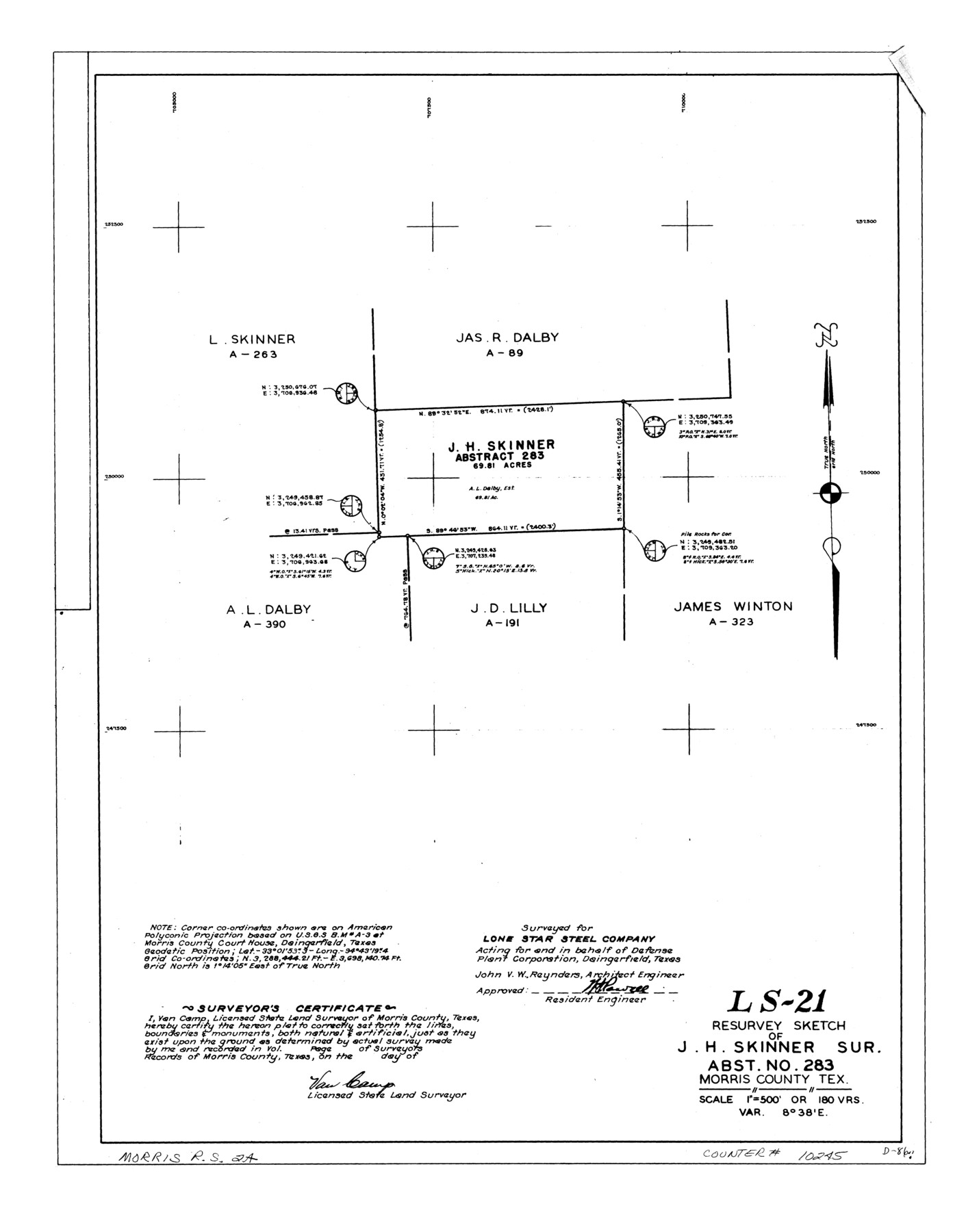
LS-21 - Resurvey sketch of J.H. Skinner sur., abst. no. 283, Morris County, Tex.
-
Map/Doc
10245
-
Collection
General Map Collection
-
People and Organizations
Van Camp (Surveyor/Engineer)
-
Counties
Morris
-
Subjects
Surveying Rolled Sketch
-
Height x Width
24.4 x 19.4 inches
62.0 x 49.3 cm
-
Medium
linen, manuscript
-
Scale
1" = 180 varas
-
Comments
See Morris County Rolled Sketch 2 (9550) for map of all retracement surveys made for Lone Star Steel Company.
Related maps
Morris County Rolled Sketch 2

Print $40.00
- Digital $50.00
Morris County Rolled Sketch 2
1944
Size 59.4 x 43.5 inches
Map/Doc 9550
Part of: General Map Collection
Red River County Working Sketch 14

Print $20.00
- Digital $50.00
Red River County Working Sketch 14
1952
Size 37.8 x 22.9 inches
Map/Doc 71997
Freestone County Working Sketch 29

Print $20.00
- Digital $50.00
Freestone County Working Sketch 29
1994
Size 36.0 x 45.5 inches
Map/Doc 69271
Flight Mission No. BRE-5P, Frame 191, Nueces County

Print $20.00
- Digital $50.00
Flight Mission No. BRE-5P, Frame 191, Nueces County
1956
Size 18.7 x 22.5 inches
Map/Doc 86837
Wilbarger County Working Sketch 17

Print $20.00
- Digital $50.00
Wilbarger County Working Sketch 17
1957
Size 7.5 x 18.4 inches
Map/Doc 72555
Flight Mission No. CLL-3N, Frame 12, Willacy County

Print $20.00
- Digital $50.00
Flight Mission No. CLL-3N, Frame 12, Willacy County
1954
Size 18.4 x 22.0 inches
Map/Doc 87078
Travis County Boundary File 1

Print $8.00
- Digital $50.00
Travis County Boundary File 1
Size 9.0 x 14.6 inches
Map/Doc 59403
Shelby County Sketch File 13

Print $2.00
- Digital $50.00
Shelby County Sketch File 13
1859
Size 8.2 x 12.8 inches
Map/Doc 36621
Flight Mission No. BQY-4M, Frame 114, Harris County

Print $20.00
- Digital $50.00
Flight Mission No. BQY-4M, Frame 114, Harris County
1953
Size 18.7 x 22.5 inches
Map/Doc 85281
Scurry County Rolled Sketch 2

Print $20.00
- Digital $50.00
Scurry County Rolled Sketch 2
Size 44.0 x 44.9 inches
Map/Doc 9911
Parker County Sketch File 48

Print $20.00
- Digital $50.00
Parker County Sketch File 48
1858
Size 17.6 x 22.3 inches
Map/Doc 12152
Wheeler County Working Sketch 16

Print $20.00
- Digital $50.00
Wheeler County Working Sketch 16
1982
Size 38.9 x 25.8 inches
Map/Doc 72505
Culberson County Working Sketch 77

Print $20.00
- Digital $50.00
Culberson County Working Sketch 77
1975
Size 36.7 x 43.3 inches
Map/Doc 68531
You may also like
Flight Mission No. BQR-13K, Frame 166, Brazoria County

Print $20.00
- Digital $50.00
Flight Mission No. BQR-13K, Frame 166, Brazoria County
1952
Size 18.8 x 22.3 inches
Map/Doc 84091
Brewster County Sketch File N-30

Print $6.00
- Digital $50.00
Brewster County Sketch File N-30
1969
Size 11.2 x 8.9 inches
Map/Doc 15708
General Highway Map, Duval County, Texas

Print $20.00
General Highway Map, Duval County, Texas
1940
Size 18.5 x 25.0 inches
Map/Doc 79079
Maverick County Working Sketch 3

Print $20.00
- Digital $50.00
Maverick County Working Sketch 3
1939
Size 34.4 x 24.8 inches
Map/Doc 70895
Kaufman County State Real Property Sketch 1

Print $92.00
- Digital $50.00
Kaufman County State Real Property Sketch 1
2006
Size 24.6 x 35.4 inches
Map/Doc 88624
Reagan County Working Sketch 14a

Print $20.00
- Digital $50.00
Reagan County Working Sketch 14a
1949
Size 25.9 x 15.2 inches
Map/Doc 71854
Wichita County

Print $20.00
- Digital $50.00
Wichita County
1971
Size 35.8 x 37.7 inches
Map/Doc 77457
Preliminary Chart of Entrance to Brazos River, Texas

Print $20.00
- Digital $50.00
Preliminary Chart of Entrance to Brazos River, Texas
1858
Size 18.4 x 19.5 inches
Map/Doc 69973
Current Miscellaneous File 112

Print $138.00
- Digital $50.00
Current Miscellaneous File 112
Size 11.3 x 8.7 inches
Map/Doc 74718
General Highway Map. Detail of Cities and Towns in Tarrant County, Texas. City Map, Fort Worth and vicinity, Tarrant County, Texas

Print $20.00
General Highway Map. Detail of Cities and Towns in Tarrant County, Texas. City Map, Fort Worth and vicinity, Tarrant County, Texas
1961
Size 18.4 x 25.1 inches
Map/Doc 79666
Flight Mission No. CGI-4N, Frame 175, Cameron County

Print $20.00
- Digital $50.00
Flight Mission No. CGI-4N, Frame 175, Cameron County
1955
Size 18.6 x 22.4 inches
Map/Doc 84678
Crockett County Working Sketch 42

Print $20.00
- Digital $50.00
Crockett County Working Sketch 42
1930
Size 25.8 x 28.0 inches
Map/Doc 68375