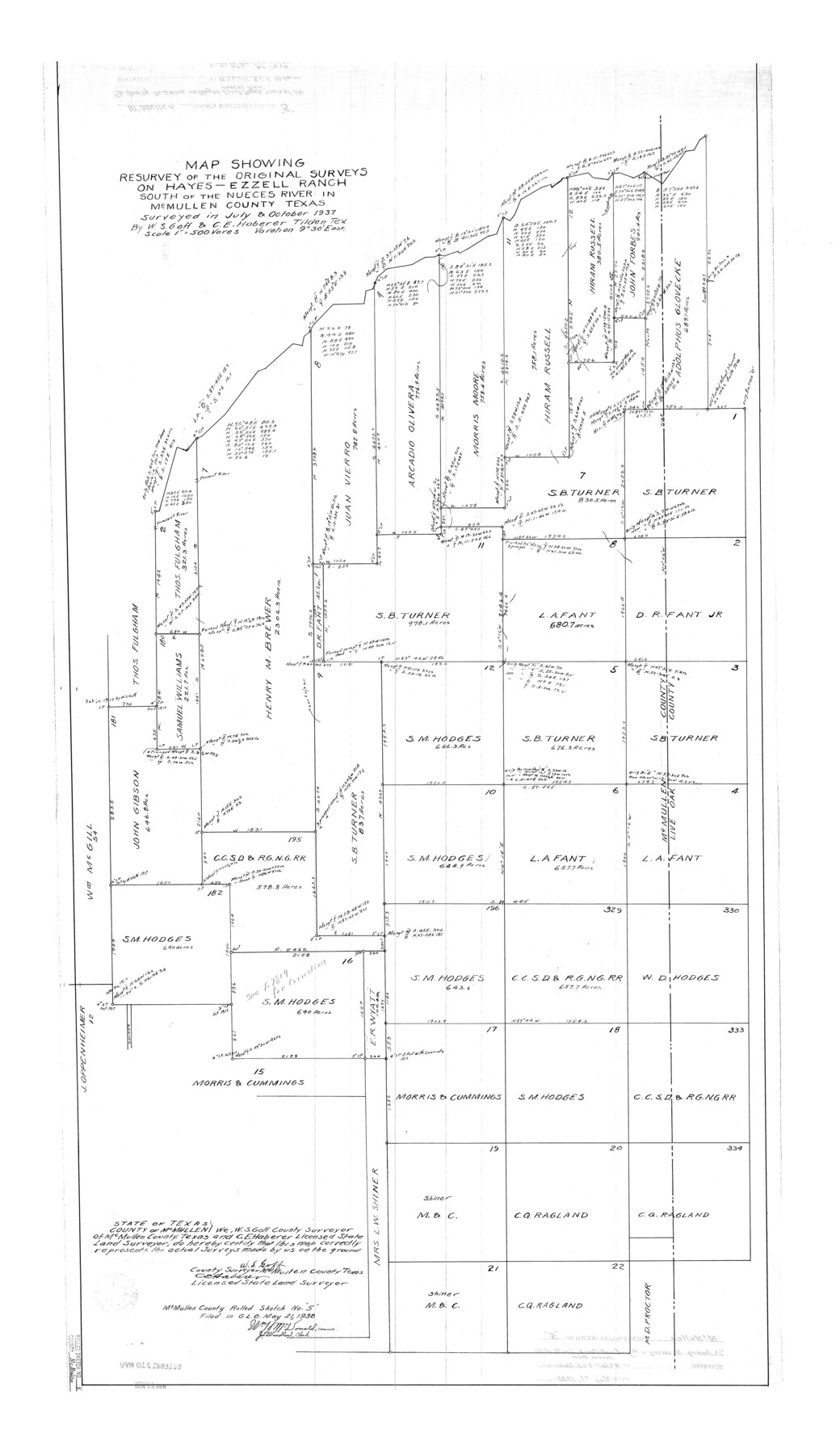
McMullen County Rolled Sketch 5
Map showing resurvey of the original surveys on Hayes-Ezzell Ranch south of the Nueces River in McMullen County, Texas
-
Map/Doc
6723
-
Collection
General Map Collection
-
Object Dates
1938/5/21 (File Date)
1937 (Survey Date)
-
People and Organizations
C.E. Haberer (Surveyor/Engineer)
W.S. Goff (Surveyor/Engineer)
-
Counties
McMullen Live Oak
-
Subjects
Surveying Rolled Sketch
-
Height x Width
46.4 x 26.8 inches
117.9 x 68.1 cm
-
Scale
1" = 500 varas
Part of: General Map Collection
Matagorda County Working Sketch 2

Print $20.00
- Digital $50.00
Matagorda County Working Sketch 2
Size 32.6 x 37.0 inches
Map/Doc 70860
Haskell County Boundary File 1a

Print $40.00
- Digital $50.00
Haskell County Boundary File 1a
Size 34.9 x 38.3 inches
Map/Doc 54536
Starr County Rolled Sketch 34

Print $20.00
- Digital $50.00
Starr County Rolled Sketch 34
1945
Size 20.8 x 17.9 inches
Map/Doc 7831
Flight Mission No. CRC-4R, Frame 160, Chambers County

Print $20.00
- Digital $50.00
Flight Mission No. CRC-4R, Frame 160, Chambers County
1956
Size 18.5 x 22.3 inches
Map/Doc 84919
Stonewall County Sketch File 6

Print $10.00
- Digital $50.00
Stonewall County Sketch File 6
1891
Size 14.0 x 8.7 inches
Map/Doc 37208
Stephens County Boundary File 6

Print $12.00
- Digital $50.00
Stephens County Boundary File 6
Size 13.0 x 8.5 inches
Map/Doc 58901
Galveston County Rolled Sketch 25

Print $20.00
- Digital $50.00
Galveston County Rolled Sketch 25
1965
Size 18.7 x 24.5 inches
Map/Doc 5959
Flight Mission No. CRC-5R, Frame 22, Chambers County

Print $20.00
- Digital $50.00
Flight Mission No. CRC-5R, Frame 22, Chambers County
1956
Size 18.7 x 22.6 inches
Map/Doc 84944
Comal County Sketch File 8

Print $6.00
- Digital $50.00
Comal County Sketch File 8
1849
Size 12.6 x 10.8 inches
Map/Doc 19013
Stieler Map of 1879

Print $4.00
- Digital $50.00
Stieler Map of 1879
1879
Size 28.9 x 23.0 inches
Map/Doc 76055
Lubbock County Sketch File 3

Print $4.00
- Digital $50.00
Lubbock County Sketch File 3
1901
Size 13.0 x 8.2 inches
Map/Doc 30420
Nacogdoches County Sketch File 19

Print $12.00
- Digital $50.00
Nacogdoches County Sketch File 19
1846
Size 17.0 x 11.0 inches
Map/Doc 32270
You may also like
Ladonia, Fannin County, Texas

Print $20.00
Ladonia, Fannin County, Texas
1891
Size 12.0 x 22.1 inches
Map/Doc 89097
Crockett County Working Sketch 74

Print $20.00
- Digital $50.00
Crockett County Working Sketch 74
1964
Size 29.4 x 22.1 inches
Map/Doc 68407
Bee County Sketch File 3

Print $6.00
- Digital $50.00
Bee County Sketch File 3
1846
Size 12.5 x 7.6 inches
Map/Doc 14261
Freestone County Working Sketch 31a

Print $20.00
- Digital $50.00
Freestone County Working Sketch 31a
1996
Size 25.4 x 31.9 inches
Map/Doc 69273
Val Verde County Working Sketch 51

Print $20.00
- Digital $50.00
Val Verde County Working Sketch 51
1952
Size 24.5 x 30.0 inches
Map/Doc 72186
Plan of Mier. The Texian Camp and Attack on the City

Print $20.00
Plan of Mier. The Texian Camp and Attack on the City
1842
Size 8.7 x 11.4 inches
Map/Doc 76305
Flight Mission No. BRE-2P, Frame 97, Nueces County

Print $20.00
- Digital $50.00
Flight Mission No. BRE-2P, Frame 97, Nueces County
1956
Size 18.5 x 22.3 inches
Map/Doc 86782
Presidio County Working Sketch 90

Print $20.00
- Digital $50.00
Presidio County Working Sketch 90
1973
Size 25.5 x 28.1 inches
Map/Doc 71767
Medina County Rolled Sketch 21

Print $20.00
- Digital $50.00
Medina County Rolled Sketch 21
2002
Size 33.5 x 19.1 inches
Map/Doc 76412

The North Part of America Conteyning Newfoundland, New England, Virginia, Florida, New Spaine, and Nova Francia

Print $20.00
- Digital $50.00
The North Part of America Conteyning Newfoundland, New England, Virginia, Florida, New Spaine, and Nova Francia
1625
Size 12.6 x 16.2 inches
Map/Doc 97028
Edwards County Rolled Sketch 19

Print $20.00
- Digital $50.00
Edwards County Rolled Sketch 19
1947
Size 21.3 x 24.0 inches
Map/Doc 5808