Montgomery County Rolled Sketch 32
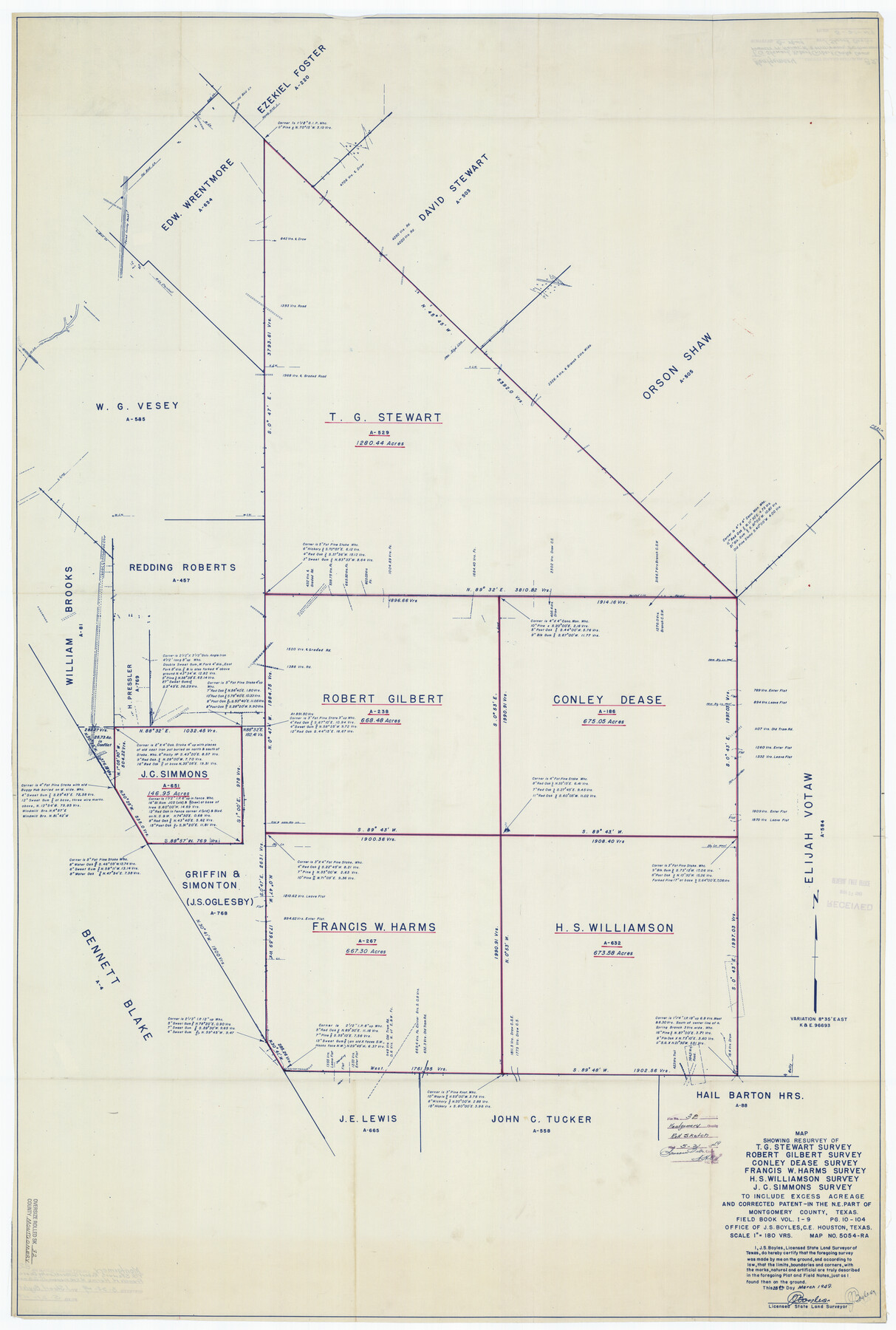
Map showing survey of T.G. Stewart survey, Robert Gilbert survey, Conley Dease survey, Francis W. Harms survey, H.S. Williamson survey, J.C. Simmons survey, to include excess acreage and corrected patent - in the NE part of Montgomery County, Texas
-
Map/Doc
9540
-
Collection
General Map Collection
-
Object Dates
1949/3/28 (Creation Date)
1949/5/21 (File Date)
-
People and Organizations
J.S. Boyles (Surveyor/Engineer)
-
Counties
Montgomery
-
Subjects
Surveying Rolled Sketch
-
Height x Width
59.9 x 40.4 inches
152.1 x 102.6 cm
-
Medium
blueprint/diazo
-
Scale
1" = 180 varas
Part of: General Map Collection
Glasscock County Working Sketch 8

Print $20.00
- Digital $50.00
Glasscock County Working Sketch 8
Size 42.7 x 10.3 inches
Map/Doc 62189
Real County Rolled Sketch 18

Print $20.00
- Digital $50.00
Real County Rolled Sketch 18
Size 21.2 x 27.7 inches
Map/Doc 7465
Montgomery County Working Sketch 14

Print $20.00
- Digital $50.00
Montgomery County Working Sketch 14
1934
Size 18.5 x 20.1 inches
Map/Doc 71121
Flight Mission No. CGN-3P, Frame 24, San Patricio County

Print $20.00
- Digital $50.00
Flight Mission No. CGN-3P, Frame 24, San Patricio County
1956
Size 18.5 x 22.3 inches
Map/Doc 86982
Flight Mission No. CGI-3N, Frame 141, Cameron County

Print $20.00
- Digital $50.00
Flight Mission No. CGI-3N, Frame 141, Cameron County
1954
Size 18.6 x 22.3 inches
Map/Doc 84614
Presidio County Working Sketch Graphic Index, West Part, Sheet 1 (Sketches 1 to 74)

Print $20.00
- Digital $50.00
Presidio County Working Sketch Graphic Index, West Part, Sheet 1 (Sketches 1 to 74)
1974
Size 40.3 x 31.4 inches
Map/Doc 76672
Wood County Sketch File 3

Print $4.00
- Digital $50.00
Wood County Sketch File 3
1848
Size 10.1 x 8.1 inches
Map/Doc 40633
Scurry County Working Sketch 1

Print $20.00
- Digital $50.00
Scurry County Working Sketch 1
Size 17.9 x 22.7 inches
Map/Doc 63830
Flight Mission No. BRA-7M, Frame 7, Jefferson County

Print $20.00
- Digital $50.00
Flight Mission No. BRA-7M, Frame 7, Jefferson County
1953
Size 18.7 x 22.5 inches
Map/Doc 85458
Flight Mission No. BRE-2P, Frame 73, Nueces County

Print $20.00
- Digital $50.00
Flight Mission No. BRE-2P, Frame 73, Nueces County
1956
Size 18.5 x 22.5 inches
Map/Doc 86768
Flight Mission No. DQN-2K, Frame 128, Calhoun County

Print $20.00
- Digital $50.00
Flight Mission No. DQN-2K, Frame 128, Calhoun County
1953
Size 18.6 x 22.3 inches
Map/Doc 84302
Angelina County Sketch File 18b

Print $40.00
- Digital $50.00
Angelina County Sketch File 18b
Size 12.6 x 16.2 inches
Map/Doc 13032
You may also like
Hunt County Sketch File 10

Print $4.00
- Digital $50.00
Hunt County Sketch File 10
1859
Size 12.4 x 8.0 inches
Map/Doc 27100

Briscoe County Sketch File H-1

Print $40.00
- Digital $50.00
Briscoe County Sketch File H-1
Size 21.7 x 18.2 inches
Map/Doc 11006
Webb County Working Sketch 27

Print $20.00
- Digital $50.00
Webb County Working Sketch 27
1932
Size 24.0 x 19.5 inches
Map/Doc 72392
Edwards County Working Sketch 89

Print $40.00
- Digital $50.00
Edwards County Working Sketch 89
1966
Size 49.7 x 28.8 inches
Map/Doc 68965
North Half, Harris County, Texas - Ownership Map with Well Data

North Half, Harris County, Texas - Ownership Map with Well Data
1948
Size 121.9 x 44.3 inches
Map/Doc 93206
Potter County Sketch File 23

Print $4.00
- Digital $50.00
Potter County Sketch File 23
Size 11.1 x 8.7 inches
Map/Doc 34421
Brewster County Working Sketch 85

Print $20.00
- Digital $50.00
Brewster County Working Sketch 85
1973
Size 43.2 x 34.0 inches
Map/Doc 67685
Pecos County Rolled Sketch JAS

Print $20.00
- Digital $50.00
Pecos County Rolled Sketch JAS
1937
Size 34.9 x 31.4 inches
Map/Doc 9744
Wichita County Sketch File 36

Print $20.00
- Digital $50.00
Wichita County Sketch File 36
1894
Size 20.1 x 25.9 inches
Map/Doc 12689
Ochiltree County Sketch File A

Print $22.00
- Digital $50.00
Ochiltree County Sketch File A
1888
Size 8.7 x 5.7 inches
Map/Doc 33167
Rockwall County Sketch File 5

Print $6.00
Rockwall County Sketch File 5
1861
Size 13.0 x 8.3 inches
Map/Doc 35422