Wichita County Sketch File 36
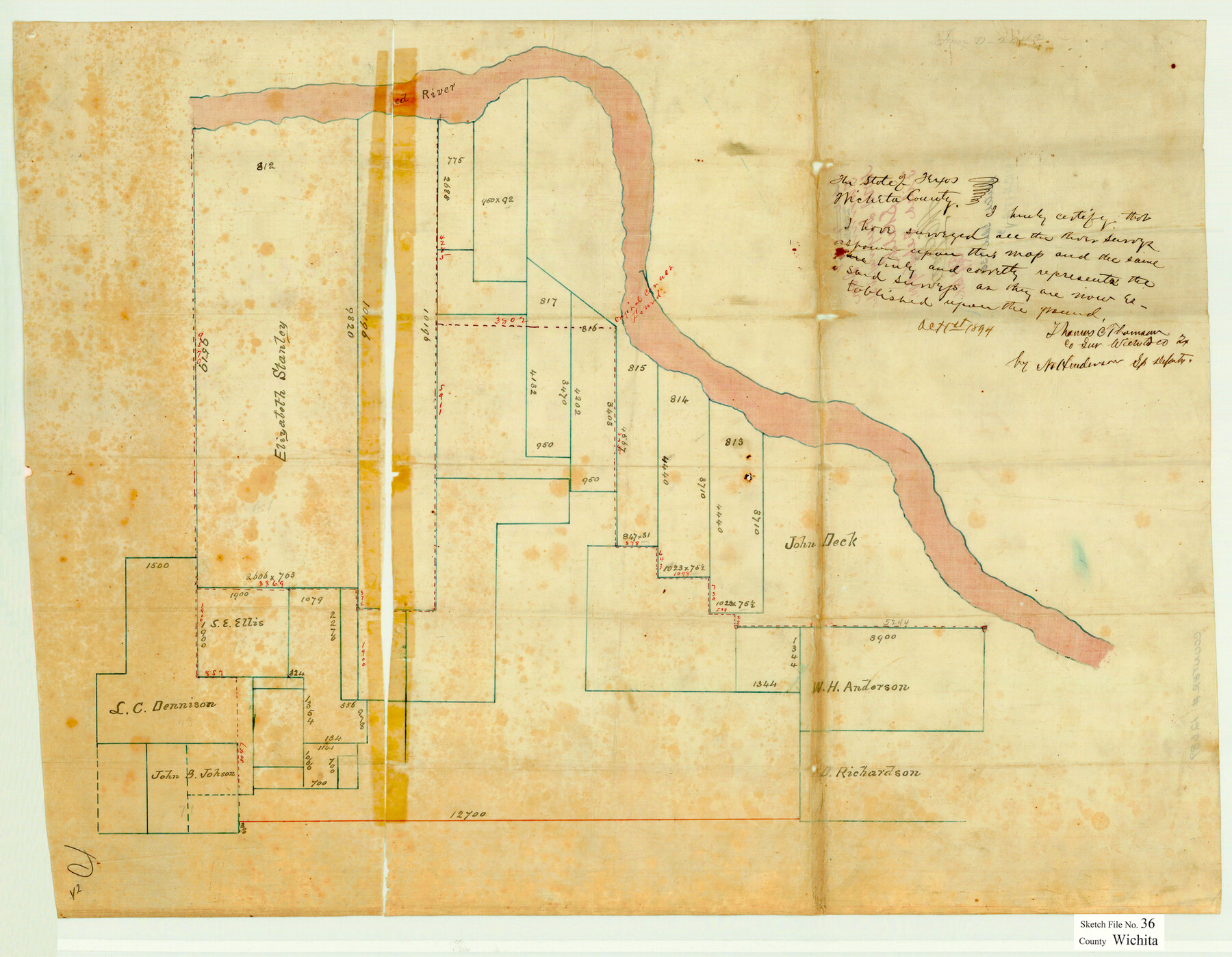
[Sketch of surveys on the Red River from the Elizabeth Stanley survey on the west to the John Deck survey on the east and surveys to the south]
-
Map/Doc
12689
-
Collection
General Map Collection
-
Object Dates
10/1/1894 (Creation Date)
2/18/1895 (File Date)
-
People and Organizations
Thomas C. Thomson (Surveyor/Engineer)
N. Henderson (Surveyor/Engineer)
-
Counties
Wichita
-
Subjects
Surveying Sketch File
-
Height x Width
20.1 x 25.9 inches
51.1 x 65.8 cm
-
Medium
paper, manuscript
-
Features
Red River
Part of: General Map Collection
East Part of Edwards County

Print $40.00
- Digital $50.00
East Part of Edwards County
1975
Size 55.7 x 40.5 inches
Map/Doc 73138
Reagan County Working Sketch 22

Print $20.00
- Digital $50.00
Reagan County Working Sketch 22
1955
Size 24.2 x 24.4 inches
Map/Doc 71864
Culberson County Working Sketch 54

Print $20.00
- Digital $50.00
Culberson County Working Sketch 54
1974
Size 26.4 x 32.6 inches
Map/Doc 68508
King County Working Sketch 17

Print $40.00
- Digital $50.00
King County Working Sketch 17
1979
Size 32.2 x 59.3 inches
Map/Doc 70181
Real County Rolled Sketch JCA

Print $20.00
- Digital $50.00
Real County Rolled Sketch JCA
Size 27.9 x 36.5 inches
Map/Doc 7470
Stonewall County Working Sketch 13

Print $20.00
- Digital $50.00
Stonewall County Working Sketch 13
1951
Size 31.9 x 33.7 inches
Map/Doc 62320
Val Verde County Working Sketch 9

Print $20.00
- Digital $50.00
Val Verde County Working Sketch 9
1917
Size 19.4 x 30.9 inches
Map/Doc 72144
Mason County Working Sketch 8

Print $20.00
- Digital $50.00
Mason County Working Sketch 8
1946
Size 22.9 x 32.3 inches
Map/Doc 70844
Fort Bend Co.

Print $20.00
- Digital $50.00
Fort Bend Co.
1931
Size 40.2 x 41.8 inches
Map/Doc 95500
La Salle County Working Sketch 42

Print $20.00
- Digital $50.00
La Salle County Working Sketch 42
1976
Size 33.4 x 33.3 inches
Map/Doc 70343
Wise County Sketch File 9

Print $5.00
- Digital $50.00
Wise County Sketch File 9
1854
Size 11.9 x 14.8 inches
Map/Doc 40539
Baylor County Sketch File Z3

Print $8.00
- Digital $50.00
Baylor County Sketch File Z3
1908
Size 12.9 x 8.3 inches
Map/Doc 14110
You may also like
Hamilton County

Print $20.00
- Digital $50.00
Hamilton County
1916
Size 42.3 x 43.2 inches
Map/Doc 66850
Colorado River, Pinoak Creek Sheet

Print $6.00
- Digital $50.00
Colorado River, Pinoak Creek Sheet
1941
Size 27.5 x 35.2 inches
Map/Doc 65312
Montgomery County Working Sketch 67

Print $20.00
- Digital $50.00
Montgomery County Working Sketch 67
1972
Size 35.0 x 29.6 inches
Map/Doc 71174
[Block 1, B. S. & F.]
![90492, [Block 1, B. S. & F.], Twichell Survey Records](https://historictexasmaps.com/wmedia_w700/maps/90492-1.tif.jpg)
Print $2.00
- Digital $50.00
[Block 1, B. S. & F.]
1904
Size 8.3 x 10.5 inches
Map/Doc 90492
Flight Mission No. DAG-21K, Frame 40, Matagorda County

Print $20.00
- Digital $50.00
Flight Mission No. DAG-21K, Frame 40, Matagorda County
1952
Size 18.6 x 19.3 inches
Map/Doc 86407

Map of Concho County, Texas

Print $20.00
- Digital $50.00
Map of Concho County, Texas
1879
Size 28.8 x 23.9 inches
Map/Doc 703
Johnson County Boundary File 51

Print $66.00
- Digital $50.00
Johnson County Boundary File 51
Size 8.5 x 4.2 inches
Map/Doc 55589
Famous Heights Park Addition, Map Showing Proposed Park and Plan of Subdividing Famous Heights Plus Park, Addition to the city of Amarillo, Texas

Print $40.00
- Digital $50.00
Famous Heights Park Addition, Map Showing Proposed Park and Plan of Subdividing Famous Heights Plus Park, Addition to the city of Amarillo, Texas
1907
Size 62.5 x 37.4 inches
Map/Doc 93117
Mitchell County Boundary File 66

Print $13.00
- Digital $50.00
Mitchell County Boundary File 66
Size 7.9 x 3.7 inches
Map/Doc 57372
Ward County Rolled Sketch 24B

Print $40.00
- Digital $50.00
Ward County Rolled Sketch 24B
1967
Size 24.7 x 56.4 inches
Map/Doc 10115
