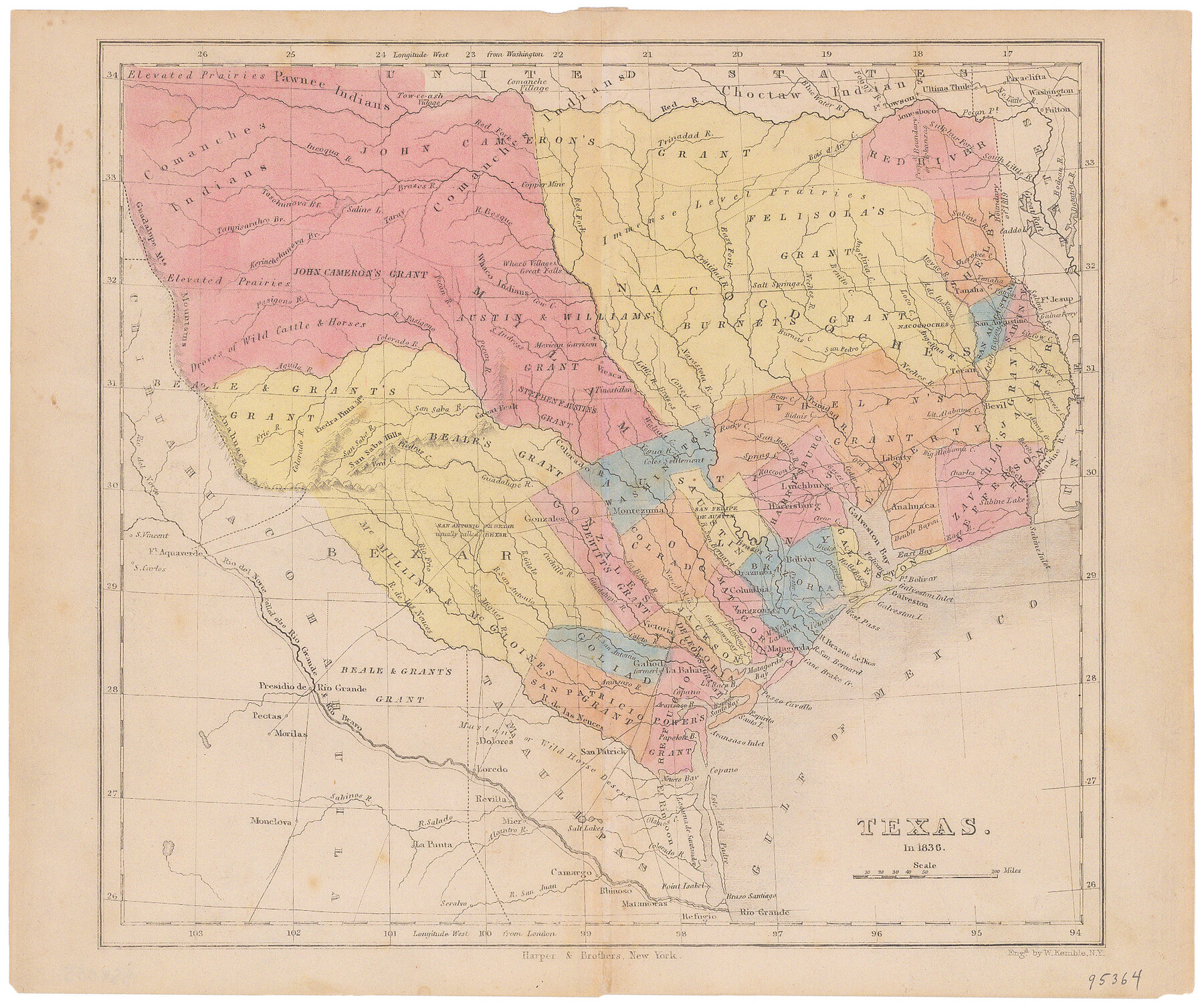
Texas in 1836
-
Map/Doc
95364
-
Collection
General Map Collection
-
Object Dates
1846 (Creation Date)
-
People and Organizations
Harper & Brothers (Publisher)
W. Kemble (Printer)
W. Kemble (Engraver)
-
Subjects
Mexican Texas Republic of Texas
-
Height x Width
9.3 x 11.1 inches
23.6 x 28.2 cm
-
Medium
paper, etching/engraving/lithograph
-
Comments
Map partially adopted by Susan and Andy Smolenski in 2019.
Part of: General Map Collection
Liberty County Sketch File 43

Print $4.00
- Digital $50.00
Liberty County Sketch File 43
1863
Size 13.6 x 8.5 inches
Map/Doc 30000
Outline Map showing a New Route from Texas to Fort Yuma, California for Cattle Droves and Trains En route to California

Print $40.00
- Digital $50.00
Outline Map showing a New Route from Texas to Fort Yuma, California for Cattle Droves and Trains En route to California
1880
Size 17.5 x 52.2 inches
Map/Doc 97141
Flight Mission No. DQN-2K, Frame 47, Calhoun County

Print $20.00
- Digital $50.00
Flight Mission No. DQN-2K, Frame 47, Calhoun County
1953
Size 18.5 x 22.2 inches
Map/Doc 84252
Flight Mission No. CRK-5P, Frame 125, Refugio County

Print $20.00
- Digital $50.00
Flight Mission No. CRK-5P, Frame 125, Refugio County
1956
Size 18.3 x 22.3 inches
Map/Doc 86928
King County Sketch File 10

Print $24.00
- Digital $50.00
King County Sketch File 10
1902
Size 14.2 x 8.7 inches
Map/Doc 29083
Irion County Sketch File 17

Print $20.00
- Digital $50.00
Irion County Sketch File 17
Size 26.7 x 40.5 inches
Map/Doc 10617
Township No. 1 North Range No. 27 West Indian Meridian

Print $20.00
- Digital $50.00
Township No. 1 North Range No. 27 West Indian Meridian
1875
Size 19.3 x 24.6 inches
Map/Doc 75170
Roberts County Working Sketch 32

Print $20.00
- Digital $50.00
Roberts County Working Sketch 32
1978
Size 26.6 x 22.5 inches
Map/Doc 63558
Presidio County Working Sketch 150

Print $20.00
- Digital $50.00
Presidio County Working Sketch 150
2002
Size 24.0 x 23.5 inches
Map/Doc 93490
Kendall County Sketch File 20

Print $42.00
- Digital $50.00
Kendall County Sketch File 20
1916
Size 9.7 x 6.3 inches
Map/Doc 28713
Webb County Working Sketch 9

Print $20.00
- Digital $50.00
Webb County Working Sketch 9
1911
Size 17.2 x 30.8 inches
Map/Doc 72374
Kimble County Working Sketch 74

Print $20.00
- Digital $50.00
Kimble County Working Sketch 74
1966
Size 43.1 x 34.2 inches
Map/Doc 70142
You may also like
Brewster County Rolled Sketch 28

Print $20.00
- Digital $50.00
Brewster County Rolled Sketch 28
1910
Size 25.6 x 29.4 inches
Map/Doc 5215
The Mexican Municipality of Gonzales. April 1834

Print $20.00
The Mexican Municipality of Gonzales. April 1834
2020
Size 20.4 x 21.7 inches
Map/Doc 96021
Tom Green County Sketch File 77

Print $6.00
- Digital $50.00
Tom Green County Sketch File 77
Size 10.0 x 8.5 inches
Map/Doc 38253

Terry County Sketch File 3

Print $20.00
- Digital $50.00
Terry County Sketch File 3
1948
Size 16.2 x 39.0 inches
Map/Doc 10390

Hudspeth County Sketch File 22

Print $10.00
- Digital $50.00
Hudspeth County Sketch File 22
1935
Size 11.2 x 8.7 inches
Map/Doc 26974
The Chief Justice County of Colorado. Lands in Conflict with Brazoria, Mina Counties

Print $20.00
The Chief Justice County of Colorado. Lands in Conflict with Brazoria, Mina Counties
2020
Size 14.8 x 21.7 inches
Map/Doc 96045


Presidio County Rolled Sketch 66

Print $20.00
- Digital $50.00
Presidio County Rolled Sketch 66
1920
Size 19.4 x 37.5 inches
Map/Doc 7357
Galveston County Rolled Sketch 10

Print $20.00
- Digital $50.00
Galveston County Rolled Sketch 10
1916
Size 21.0 x 38.0 inches
Map/Doc 5952