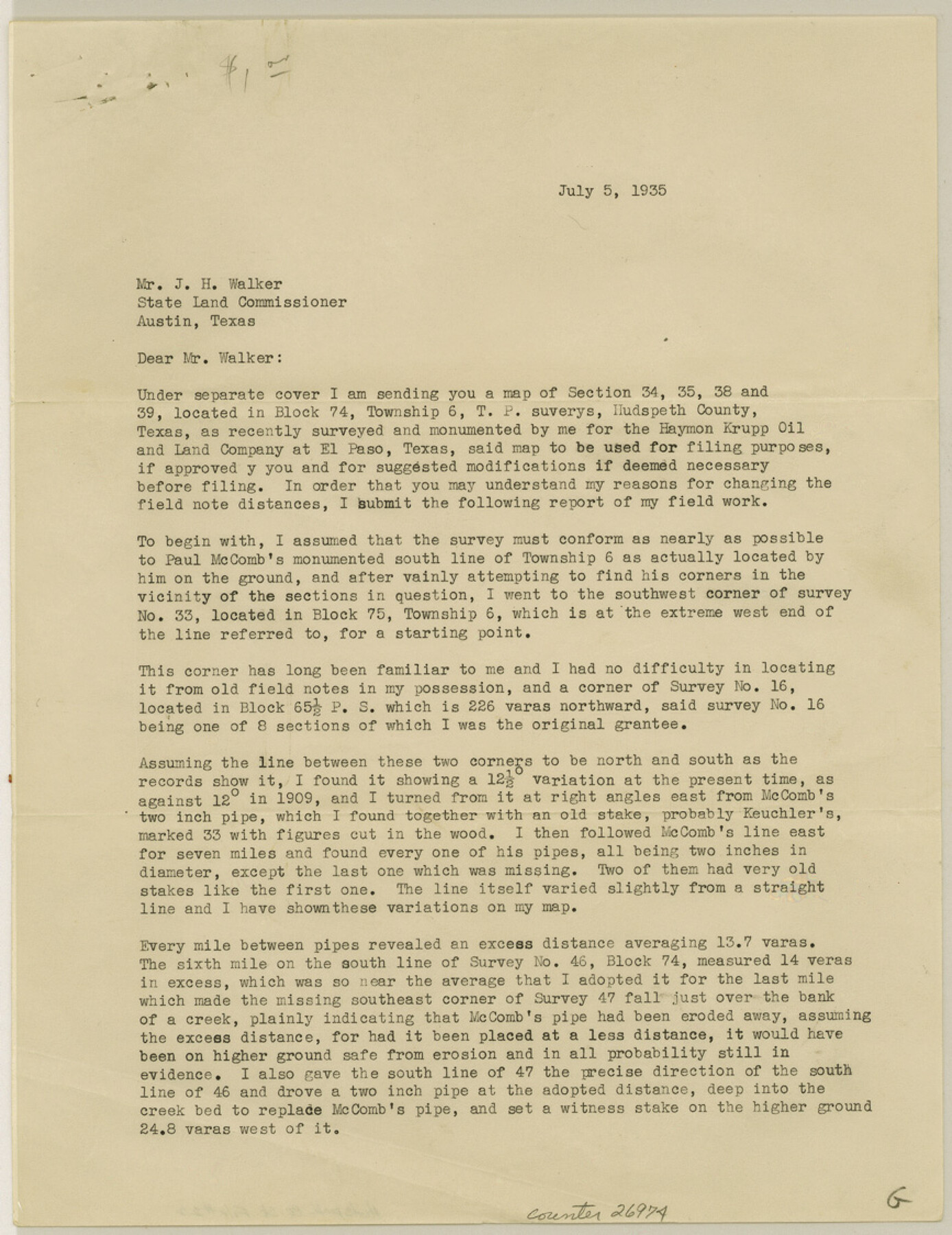
Hudspeth County Sketch File 22
[Statement regarding sections 34, 35, 38 and 39, Block 74, Township 6 S]
-
Map/Doc
26974
-
Collection
General Map Collection
-
Object Dates
7/3/1935 (Creation Date)
7/12/1935 (File Date)
7/5/1935 (Correspondence Date)
7/10/1935 (Correspondence Date)
8/19/1935 (Correspondence Date)
-
People and Organizations
W.J. Powell (Surveyor/Engineer)
Paul McCombs (Surveyor/Engineer)
Keuchler (Surveyor/Engineer)
W.L. Rider (Surveyor/Engineer)
-
Counties
Hudspeth
-
Subjects
Surveying Sketch File
-
Height x Width
11.2 x 8.7 inches
28.5 x 22.1 cm
-
Medium
paper, print
-
Comments
See Hudspeth County Sketch File 23 (11801) for sketch.
-
Features
Sierra Blanca
Related maps
Hudspeth County Sketch File 23

Print $20.00
- Digital $50.00
Hudspeth County Sketch File 23
1935
Size 15.1 x 26.9 inches
Map/Doc 11801
Part of: General Map Collection
Eastland County Working Sketch Graphic Index

Print $20.00
- Digital $50.00
Eastland County Working Sketch Graphic Index
1945
Size 41.6 x 42.4 inches
Map/Doc 76529

Brazoria County NRC Article 33.136 Sketch 2

Print $20.00
- Digital $50.00
Brazoria County NRC Article 33.136 Sketch 2
2002
Size 40.6 x 29.7 inches
Map/Doc 77038
Palo Pinto County Sketch File 8

Print $40.00
- Digital $50.00
Palo Pinto County Sketch File 8
Size 15.3 x 15.6 inches
Map/Doc 33400
Flight Mission No. DQO-7K, Frame 81, Galveston County

Print $20.00
- Digital $50.00
Flight Mission No. DQO-7K, Frame 81, Galveston County
1952
Size 18.8 x 22.6 inches
Map/Doc 85108
Refugio County Boundary File 3a

Print $28.00
- Digital $50.00
Refugio County Boundary File 3a
Size 14.1 x 8.8 inches
Map/Doc 58246
Gulf of Mexico

Print $20.00
- Digital $50.00
Gulf of Mexico
1900
Size 18.4 x 28.1 inches
Map/Doc 72649
Fannin County Sketch File 4

Print $4.00
- Digital $50.00
Fannin County Sketch File 4
Size 9.9 x 8.0 inches
Map/Doc 22449
Flight Mission No. DQO-1K, Frame 151, Galveston County

Print $20.00
- Digital $50.00
Flight Mission No. DQO-1K, Frame 151, Galveston County
1952
Size 18.8 x 22.5 inches
Map/Doc 85004
Map showing the fortification at Point Isabel

Print $20.00
- Digital $50.00
Map showing the fortification at Point Isabel
1864
Size 18.3 x 27.9 inches
Map/Doc 72921
Montague County Sketch File 26

Print $4.00
- Digital $50.00
Montague County Sketch File 26
1945
Size 11.3 x 8.7 inches
Map/Doc 31760
[Beaumont, Sour Lake and Western Ry. Right of Way and Alignment - Frisco]
![64128, [Beaumont, Sour Lake and Western Ry. Right of Way and Alignment - Frisco], General Map Collection](https://historictexasmaps.com/wmedia_w700/maps/64128.tif.jpg)
Print $20.00
- Digital $50.00
[Beaumont, Sour Lake and Western Ry. Right of Way and Alignment - Frisco]
1910
Size 20.1 x 45.9 inches
Map/Doc 64128
You may also like
Red River County Working Sketch 14

Print $20.00
- Digital $50.00
Red River County Working Sketch 14
1952
Size 37.8 x 22.9 inches
Map/Doc 71997
Plat of Section No. 44, Blk. No. 4, T. & P. RR. Co. showing subdivisions of same with 3.1 acre survey made for W. D. Twichell

Print $2.00
- Digital $50.00
Plat of Section No. 44, Blk. No. 4, T. & P. RR. Co. showing subdivisions of same with 3.1 acre survey made for W. D. Twichell
1919
Size 8.9 x 13.3 inches
Map/Doc 91908
Harris County Working Sketch 58

Print $20.00
- Digital $50.00
Harris County Working Sketch 58
1952
Size 24.1 x 26.5 inches
Map/Doc 65950
Colorado River, Buecher State Park

Print $4.00
- Digital $50.00
Colorado River, Buecher State Park
1934
Size 20.8 x 11.6 inches
Map/Doc 65324
Culberson County Working Sketch Graphic Index, Sheet B (Sketches 41 to Most Recent)

Print $40.00
- Digital $50.00
Culberson County Working Sketch Graphic Index, Sheet B (Sketches 41 to Most Recent)
1943
Size 52.5 x 32.5 inches
Map/Doc 76515
Flight Mission No. DAG-14K, Frame 144, Matagorda County

Print $20.00
- Digital $50.00
Flight Mission No. DAG-14K, Frame 144, Matagorda County
1952
Size 17.2 x 17.2 inches
Map/Doc 86311
The City of Austin and Suburbs

Print $40.00
- Digital $50.00
The City of Austin and Suburbs
1919
Size 120.7 x 73.5 inches
Map/Doc 2204
Roberts County Boundary File 3

Print $44.00
- Digital $50.00
Roberts County Boundary File 3
Size 14.2 x 9.3 inches
Map/Doc 58368
San Patricio County Rolled Sketch 30 & 30A

Print $20.00
- Digital $50.00
San Patricio County Rolled Sketch 30 & 30A
1941
Size 47.1 x 27.9 inches
Map/Doc 9896
Dawson County Boundary File 3 (1)

Print $40.00
- Digital $50.00
Dawson County Boundary File 3 (1)
Size 11.1 x 35.8 inches
Map/Doc 52365
[T. & P. Surveys in Crane, Upton, Coke Counties]
![90464, [T. & P. Surveys in Crane, Upton, Coke Counties], Twichell Survey Records](https://historictexasmaps.com/wmedia_w700/maps/90464-1.tif.jpg)
Print $20.00
- Digital $50.00
[T. & P. Surveys in Crane, Upton, Coke Counties]
Size 19.2 x 21.2 inches
Map/Doc 90464
Mileage Map - Best Roads of Texas showing principal cities, pole markings, road distances

Print $20.00
- Digital $50.00
Mileage Map - Best Roads of Texas showing principal cities, pole markings, road distances
1920
Size 12.8 x 16.2 inches
Map/Doc 95898