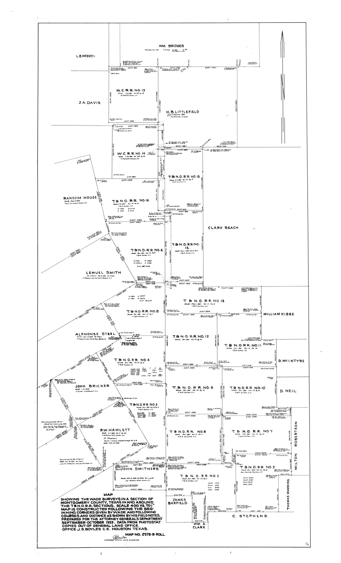
Montgomery County Rolled Sketch 19
Map showing the Wade surveys in a section of Montgomery County, Texas in and around the T. & N. O. R.R. sections
-
Map/Doc
9529
-
Collection
General Map Collection
-
Object Dates
1933 (Creation Date)
-
People and Organizations
J.S. Boyles (Surveyor/Engineer)
-
Counties
Montgomery
-
Subjects
Surveying Rolled Sketch
-
Height x Width
50.6 x 30.7 inches
128.5 x 78.0 cm
-
Scale
1" = 400 varas
Part of: General Map Collection
Haskell County Working Sketch 6

Print $20.00
- Digital $50.00
Haskell County Working Sketch 6
1949
Size 18.9 x 16.4 inches
Map/Doc 66064
Map of Retrieve Plantation, Brazoria County, Texas

Print $20.00
- Digital $50.00
Map of Retrieve Plantation, Brazoria County, Texas
Size 16.9 x 16.4 inches
Map/Doc 63000
Hood County Sketch File 22a

Print $5.00
- Digital $50.00
Hood County Sketch File 22a
Size 13.7 x 9.3 inches
Map/Doc 26617
Montgomery Co.

Print $40.00
- Digital $50.00
Montgomery Co.
1943
Size 45.1 x 53.3 inches
Map/Doc 66940
Matagorda County Sketch File 40

Print $20.00
- Digital $50.00
Matagorda County Sketch File 40
Size 33.0 x 25.5 inches
Map/Doc 12048
Brazoria County Sketch File 28a

Print $40.00
- Digital $50.00
Brazoria County Sketch File 28a
1913
Size 21.0 x 15.2 inches
Map/Doc 10954
Refugio County Boundary File 6

Print $10.00
- Digital $50.00
Refugio County Boundary File 6
Size 14.3 x 8.8 inches
Map/Doc 58257
Waller County Sketch File 9

Print $4.00
- Digital $50.00
Waller County Sketch File 9
Size 9.1 x 7.8 inches
Map/Doc 39610
Van Zandt County

Print $20.00
- Digital $50.00
Van Zandt County
1870
Size 22.9 x 21.6 inches
Map/Doc 4637
Hartley County

Print $20.00
- Digital $50.00
Hartley County
1925
Size 34.2 x 41.5 inches
Map/Doc 77306
Flight Mission No. DQN-2K, Frame 121, Calhoun County

Print $20.00
- Digital $50.00
Flight Mission No. DQN-2K, Frame 121, Calhoun County
1953
Size 16.3 x 16.3 inches
Map/Doc 84297
Flight Mission No. CON-4R, Frame 88, Stonewall County

Print $20.00
- Digital $50.00
Flight Mission No. CON-4R, Frame 88, Stonewall County
1957
Size 18.2 x 22.0 inches
Map/Doc 86992
You may also like
Dallas County Working Sketch 8

Print $20.00
- Digital $50.00
Dallas County Working Sketch 8
1953
Size 20.6 x 26.4 inches
Map/Doc 68574
Jeff Davis County Texas

Print $20.00
- Digital $50.00
Jeff Davis County Texas
Size 16.1 x 21.1 inches
Map/Doc 4572

Reeves County Working Sketch 4

Print $20.00
- Digital $50.00
Reeves County Working Sketch 4
1922
Size 32.5 x 33.1 inches
Map/Doc 63446
Flight Mission No. DCL-6C, Frame 21, Kenedy County

Print $20.00
- Digital $50.00
Flight Mission No. DCL-6C, Frame 21, Kenedy County
1943
Size 18.7 x 22.5 inches
Map/Doc 85878
Goliad County Rolled Sketch 7

Print $69.00
- Digital $50.00
Goliad County Rolled Sketch 7
1849
Size 10.6 x 16.1 inches
Map/Doc 45254
Best Route for Movements of Troops from Laredo to Ringold [sic] Barracks, Texas
![79299, Best Route for Movements of Troops from Laredo to Ringold [sic] Barracks, Texas, Texas State Library and Archives](https://historictexasmaps.com/wmedia_w700/maps/79299.tif.jpg)
Print $20.00
Best Route for Movements of Troops from Laredo to Ringold [sic] Barracks, Texas
1865
Size 18.9 x 15.3 inches
Map/Doc 79299
Working Sketch Fisher County School Land [Leagues 105-108]
![90294, Working Sketch Fisher County School Land [Leagues 105-108], Twichell Survey Records](https://historictexasmaps.com/wmedia_w700/maps/90294-1.tif.jpg)
Print $20.00
- Digital $50.00
Working Sketch Fisher County School Land [Leagues 105-108]
Size 12.9 x 16.7 inches
Map/Doc 90294
Terrell County Sketch File 1

Print $78.00
- Digital $50.00
Terrell County Sketch File 1
1881
Size 9.1 x 8.8 inches
Map/Doc 37870
Map of Edwards County, Texas

Print $20.00
- Digital $50.00
Map of Edwards County, Texas
Size 21.5 x 18.2 inches
Map/Doc 92635
Hamilton County Working Sketch 16

Print $40.00
- Digital $50.00
Hamilton County Working Sketch 16
1950
Size 48.0 x 40.6 inches
Map/Doc 63354
Brewster County Working Sketch 8

Print $20.00
- Digital $50.00
Brewster County Working Sketch 8
1910
Size 42.3 x 30.3 inches
Map/Doc 67541