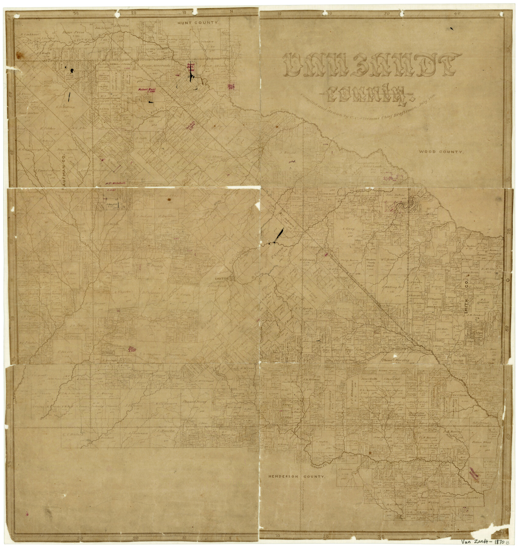
Van Zandt County
-
Map/Doc
4637
-
Collection
General Map Collection
-
Object Dates
7/1870 (Creation Date)
-
People and Organizations
C.C. Stremme (Draftsman)
-
Counties
Van Zandt
-
Subjects
County
-
Height x Width
22.9 x 21.6 inches
58.2 x 54.9 cm
-
Features
Battle Creek
Lacy's Fork of Cedar Creek
Aligator [sic] Creek
Creamleach Creek
Horsley's Creek
Neches River
Murchison's Creek
Beaver Creek
East Fork of Kickapoo Creek
Twin Creek
Deep Creek
Kickapoo Creek
Glade Creek
Kingsborough Road
Fort Houston Road
Grand Saline Lake
Rock Creek
Beechy Creek
Indian Trail
Road from Kingsborough to Fort Houston
East Fork of Creamlevel Creek
Giladon Creek
Cowleach Fork [of Sabine River]
McBee's Creek
Walnut Creek
Duck Creek
Richland Creek
Ferris Fork [of Caney Creek]
Sabine River
Grand Saline Creek
Grand Saline
South Fork of Sabine River
Rocky Bayou
Rocky Creek
Crooked Creek
Village Creek
Dry Creek
Caney Creek
Revely Creek
Canton
Lacy's Creek
Part of: General Map Collection
Flight Mission No. DCL-7C, Frame 147, Kenedy County

Print $20.00
- Digital $50.00
Flight Mission No. DCL-7C, Frame 147, Kenedy County
1943
Size 18.3 x 22.4 inches
Map/Doc 86104
Refugio County Sketch File 12

Print $4.00
- Digital $50.00
Refugio County Sketch File 12
Size 8.0 x 12.8 inches
Map/Doc 35263
Kerr County Sketch File 7

Print $4.00
- Digital $50.00
Kerr County Sketch File 7
1881
Size 8.8 x 15.7 inches
Map/Doc 28869
Live Oak County

Print $40.00
- Digital $50.00
Live Oak County
1899
Size 51.8 x 37.2 inches
Map/Doc 78404
Fort Bend Co.

Print $20.00
- Digital $50.00
Fort Bend Co.
1931
Size 40.2 x 41.8 inches
Map/Doc 95500
Jackson County Aerial Photograph Index Sheet 7

Print $20.00
- Digital $50.00
Jackson County Aerial Photograph Index Sheet 7
1956
Size 21.2 x 15.8 inches
Map/Doc 83706
Harris County Working Sketch 46

Print $20.00
- Digital $50.00
Harris County Working Sketch 46
1942
Size 19.8 x 17.7 inches
Map/Doc 65938
Trinity County

Print $20.00
- Digital $50.00
Trinity County
1946
Size 42.7 x 43.2 inches
Map/Doc 95656
Flight Mission No. BQR-3K, Frame 158, Brazoria County

Print $20.00
- Digital $50.00
Flight Mission No. BQR-3K, Frame 158, Brazoria County
1952
Size 18.7 x 22.4 inches
Map/Doc 83985
Val Verde County Sketch File 51a

Print $8.00
- Digital $50.00
Val Verde County Sketch File 51a
1959
Size 11.4 x 8.8 inches
Map/Doc 39325
Fisher County Sketch File 21

Print $6.00
- Digital $50.00
Fisher County Sketch File 21
Size 10.3 x 17.0 inches
Map/Doc 22649
Val Verde County Rolled Sketch 79

Print $20.00
- Digital $50.00
Val Verde County Rolled Sketch 79
1983
Size 25.6 x 21.7 inches
Map/Doc 8141
You may also like
Sulphur River, North Extension, Turner Lake Sheet

Print $4.00
- Digital $50.00
Sulphur River, North Extension, Turner Lake Sheet
1922
Size 17.8 x 18.6 inches
Map/Doc 65158
The Woodlands, a real hometown for people and companies

The Woodlands, a real hometown for people and companies
Size 39.0 x 26.1 inches
Map/Doc 94287
Jackson County Rolled Sketch 6

Print $20.00
- Digital $50.00
Jackson County Rolled Sketch 6
1914
Size 23.6 x 26.6 inches
Map/Doc 6341
Reconnoissance of Sabine River and Valley

Print $20.00
Reconnoissance of Sabine River and Valley
1863
Size 30.2 x 42.3 inches
Map/Doc 97499

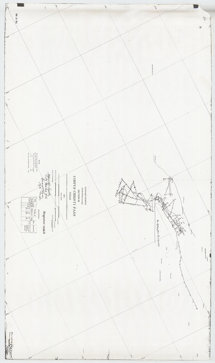
Hydrographic Survey H-1288B Corpus Christi Pass
Print $40.00
- Digital $50.00
Hydrographic Survey H-1288B Corpus Christi Pass
1875
Size 52.9 x 31.4 inches
Map/Doc 2691
Tyler County Sketch File 25

Print $28.00
- Digital $50.00
Tyler County Sketch File 25
1953
Size 14.5 x 9.0 inches
Map/Doc 38689
Pecos County Working Sketch 124

Print $40.00
- Digital $50.00
Pecos County Working Sketch 124
1974
Size 57.9 x 38.2 inches
Map/Doc 71597
Karnes County Boundary File 6

Print $16.00
- Digital $50.00
Karnes County Boundary File 6
Size 9.3 x 4.0 inches
Map/Doc 55735
Flight Mission No. DCL-4C, Frame 5, Kenedy County

Print $20.00
- Digital $50.00
Flight Mission No. DCL-4C, Frame 5, Kenedy County
1943
Size 18.6 x 22.3 inches
Map/Doc 85806
Flight Mission No. CRE-1R, Frame 122, Jackson County

Print $20.00
- Digital $50.00
Flight Mission No. CRE-1R, Frame 122, Jackson County
1956
Size 16.2 x 16.0 inches
Map/Doc 85333
Hockley County Sketch File 16

Print $20.00
- Digital $50.00
Hockley County Sketch File 16
Size 23.6 x 30.9 inches
Map/Doc 11774