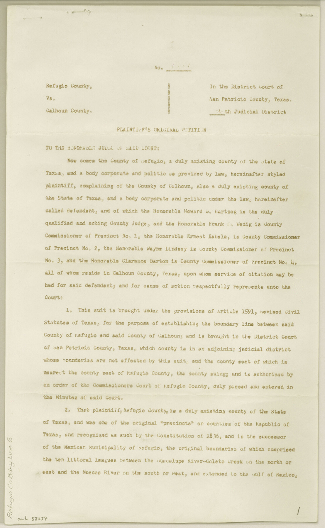
Refugio County Boundary File 6
Refugio Co. vs. Calhoun Co. - Plaintiffs Original Petition
-
Map/Doc
58257
-
Collection
General Map Collection
-
Counties
Refugio
-
Subjects
County Boundaries
-
Height x Width
14.3 x 8.8 inches
36.3 x 22.4 cm
Part of: General Map Collection
Nolan County Rolled Sketch W

Print $20.00
- Digital $50.00
Nolan County Rolled Sketch W
1902
Size 16.5 x 38.0 inches
Map/Doc 6863
The Texas and Pacific Ry. Co., Station Map, Iatan, Mitchell County, Texas

Print $20.00
- Digital $50.00
The Texas and Pacific Ry. Co., Station Map, Iatan, Mitchell County, Texas
1929
Size 11.0 x 18.4 inches
Map/Doc 64667

![94160, Austin and Vicinity [Recto], General Map Collection](https://historictexasmaps.com/wmedia_w700/maps/94160.tif.jpg)
Gaines County Rolled Sketch G3A

Print $20.00
- Digital $50.00
Gaines County Rolled Sketch G3A
1902
Size 22.5 x 31.1 inches
Map/Doc 5947
Schleicher County Sketch File 25

Print $20.00
- Digital $50.00
Schleicher County Sketch File 25
1937
Size 24.1 x 17.5 inches
Map/Doc 12304
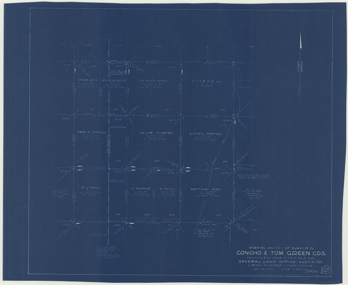
Concho County Working Sketch 15
Print $20.00
- Digital $50.00
Concho County Working Sketch 15
1955
Size 25.2 x 30.8 inches
Map/Doc 68197
Aransas County

Print $20.00
- Digital $50.00
Aransas County
1871
Size 17.2 x 18.3 inches
Map/Doc 3235
Freestone County Rolled Sketch 3

Print $67.00
- Digital $50.00
Freestone County Rolled Sketch 3
Size 10.4 x 15.5 inches
Map/Doc 44784
Flight Mission No. DQO-2K, Frame 92, Galveston County

Print $20.00
- Digital $50.00
Flight Mission No. DQO-2K, Frame 92, Galveston County
1952
Size 18.8 x 22.5 inches
Map/Doc 85019
Comanche County Working Sketch 22

Print $20.00
- Digital $50.00
Comanche County Working Sketch 22
1974
Size 23.7 x 23.1 inches
Map/Doc 68156
Coast Chart No. 210 Aransas Pass and Corpus Christi Bay with the coast to latitude 27° 12' Texas

Print $20.00
- Digital $50.00
Coast Chart No. 210 Aransas Pass and Corpus Christi Bay with the coast to latitude 27° 12' Texas
1887
Size 27.5 x 18.4 inches
Map/Doc 72786
You may also like
Andrews County Rolled Sketch 43

Print $20.00
- Digital $50.00
Andrews County Rolled Sketch 43
Size 26.1 x 41.0 inches
Map/Doc 77183
Map of the Harlem State Farm and the Central State Farm, Fort Bend County, Texas

Print $20.00
- Digital $50.00
Map of the Harlem State Farm and the Central State Farm, Fort Bend County, Texas
Size 35.7 x 32.1 inches
Map/Doc 62995
Eastland County Sketch File 14

Print $8.00
- Digital $50.00
Eastland County Sketch File 14
Size 11.5 x 9.2 inches
Map/Doc 21595
Crockett County Rolled Sketch CRV

Print $40.00
- Digital $50.00
Crockett County Rolled Sketch CRV
1925
Size 35.8 x 52.3 inches
Map/Doc 8693
Brewster County Rolled Sketch 128

Print $20.00
- Digital $50.00
Brewster County Rolled Sketch 128
1978
Size 24.9 x 28.0 inches
Map/Doc 5300
Right-of-way & Track Map Dawson Railway Operated by the El Paso & Southwestern Company Station 1021+79.7 to Station 1233+41.7

Print $40.00
- Digital $50.00
Right-of-way & Track Map Dawson Railway Operated by the El Paso & Southwestern Company Station 1021+79.7 to Station 1233+41.7
1910
Size 57.0 x 25.1 inches
Map/Doc 89661
Van Zandt County Working Sketch 2

Print $20.00
- Digital $50.00
Van Zandt County Working Sketch 2
1910
Size 17.8 x 11.6 inches
Map/Doc 72251
Castro County Sketch File 4i

Print $4.00
- Digital $50.00
Castro County Sketch File 4i
Size 13.6 x 8.9 inches
Map/Doc 17481
Bowie County Working Sketch 8

Print $20.00
- Digital $50.00
Bowie County Working Sketch 8
1953
Size 25.9 x 24.0 inches
Map/Doc 67412
Map of Kimble County

Print $40.00
- Digital $50.00
Map of Kimble County
1890
Size 36.1 x 54.4 inches
Map/Doc 78436
Crane County Sketch File 3

Print $20.00
- Digital $50.00
Crane County Sketch File 3
Size 23.6 x 26.0 inches
Map/Doc 11204
Flight Mission No. DAG-19K, Frame 60, Matagorda County

Print $20.00
- Digital $50.00
Flight Mission No. DAG-19K, Frame 60, Matagorda County
1952
Size 18.6 x 22.2 inches
Map/Doc 86387