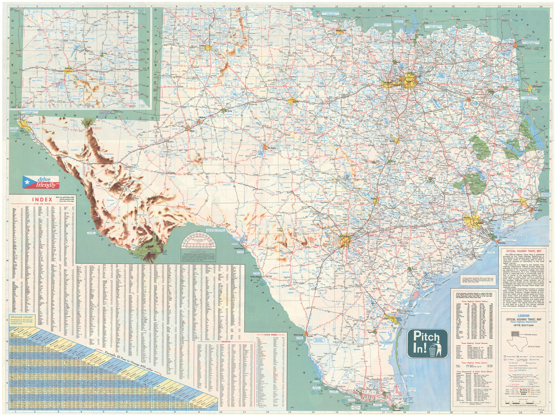
Texas Official Highway Travel Map
[Verso - Map of Texas]
-
Map/Doc
94312
-
Collection
General Map Collection
-
Object Dates
1975 (Creation Date)
-
People and Organizations
Texas Highway Department (Publisher)
-
Subjects
State of Texas
-
Height x Width
27.2 x 36.2 inches
69.1 x 92.0 cm
-
Medium
paper, etching/engraving/lithograph
-
Comments
For map of various Texas cities on recto see 94311. For reseach purposes only.
Related maps
Texas Official Highway Travel Map

Digital $50.00
Texas Official Highway Travel Map
Size 27.1 x 36.2 inches
Map/Doc 94311
Part of: General Map Collection
[Maps of surveys in Reeves & Culberson Cos]
![61142, [Maps of surveys in Reeves & Culberson Cos], General Map Collection](https://historictexasmaps.com/wmedia_w700/maps/61142.tif.jpg)
Print $20.00
- Digital $50.00
[Maps of surveys in Reeves & Culberson Cos]
1937
Size 30.6 x 24.8 inches
Map/Doc 61142
Flight Mission No. CRK-7P, Frame 26, Refugio County

Print $20.00
- Digital $50.00
Flight Mission No. CRK-7P, Frame 26, Refugio County
1956
Size 18.3 x 22.1 inches
Map/Doc 86946
Loving County Working Sketch 6

Print $40.00
- Digital $50.00
Loving County Working Sketch 6
1947
Size 31.3 x 51.0 inches
Map/Doc 70638
Flight Mission No. CZW-3R, Frame 82

Print $20.00
- Digital $50.00
Flight Mission No. CZW-3R, Frame 82
1956
Size 18.6 x 22.3 inches
Map/Doc 85240
Tarrant County State Real Property Sketch 1

Print $60.00
- Digital $50.00
Tarrant County State Real Property Sketch 1
2007
Size 24.5 x 35.3 inches
Map/Doc 88666
Prison Property, Walker Co.

Print $20.00
- Digital $50.00
Prison Property, Walker Co.
Size 34.2 x 24.7 inches
Map/Doc 94283
Controlled Mosaic by Jack Amman Photogrammetric Engineers, Inc - Sheet 3

Print $20.00
- Digital $50.00
Controlled Mosaic by Jack Amman Photogrammetric Engineers, Inc - Sheet 3
1954
Size 20.0 x 24.0 inches
Map/Doc 83447
Set of new maps of Austin's Colony by G. Borden, Jr.

Print $20.00
- Digital $50.00
Set of new maps of Austin's Colony by G. Borden, Jr.
1833
Size 25.0 x 17.0 inches
Map/Doc 131
Pecos County Rolled Sketch 113

Print $20.00
- Digital $50.00
Pecos County Rolled Sketch 113
1942
Size 31.9 x 35.4 inches
Map/Doc 9721
Newton County Rolled Sketch 28

Print $373.00
- Digital $50.00
Newton County Rolled Sketch 28
1938
Size 10.3 x 15.4 inches
Map/Doc 47418
Duval County Working Sketch 17

Print $20.00
- Digital $50.00
Duval County Working Sketch 17
1939
Size 14.6 x 25.1 inches
Map/Doc 68730
Angelina County Sketch File 13

Print $4.00
- Digital $50.00
Angelina County Sketch File 13
1860
Size 13.0 x 8.2 inches
Map/Doc 12957
You may also like
Erath County Rolled Sketch 7

Print $20.00
- Digital $50.00
Erath County Rolled Sketch 7
Size 19.2 x 24.4 inches
Map/Doc 88881
Mapa topográfico de la provincia de Texas

Print $20.00
Mapa topográfico de la provincia de Texas
1822
Size 10.2 x 13.9 inches
Map/Doc 89228
Ellwood Farms Subdivision Number 2 of the Spade Ranch Lamb and Hale Counties, Texas

Print $20.00
- Digital $50.00
Ellwood Farms Subdivision Number 2 of the Spade Ranch Lamb and Hale Counties, Texas
Size 22.2 x 31.4 inches
Map/Doc 92258
![91799, [Block 2], Twichell Survey Records](https://historictexasmaps.com/wmedia_w700/maps/91799-1.tif.jpg)
Parker County Sketch File 20

Print $4.00
- Digital $50.00
Parker County Sketch File 20
Size 5.2 x 6.5 inches
Map/Doc 33558
Tarrant County Working Sketch 6

Print $20.00
- Digital $50.00
Tarrant County Working Sketch 6
1979
Size 29.3 x 18.7 inches
Map/Doc 62423
Brewster County Working Sketch Graphic Index, North Part, Sheet 2 (Sketches 87 to Most Recent)

Print $20.00
- Digital $50.00
Brewster County Working Sketch Graphic Index, North Part, Sheet 2 (Sketches 87 to Most Recent)
1956
Size 41.8 x 39.5 inches
Map/Doc 76474
Houston County Rolled Sketch 12

Print $20.00
- Digital $50.00
Houston County Rolled Sketch 12
Size 11.8 x 18.1 inches
Map/Doc 95396
Hood County Rolled Sketch 5

Print $20.00
- Digital $50.00
Hood County Rolled Sketch 5
1980
Size 29.9 x 32.2 inches
Map/Doc 6221
Upton County Sketch File 19

Print $20.00
- Digital $50.00
Upton County Sketch File 19
1927
Size 21.2 x 21.4 inches
Map/Doc 12515
Map of Retrieve Plantation, Brazoria County, Texas

Print $20.00
- Digital $50.00
Map of Retrieve Plantation, Brazoria County, Texas
Size 16.9 x 16.4 inches
Map/Doc 63000
Tom Green County Sketch File 77

Print $6.00
- Digital $50.00
Tom Green County Sketch File 77
Size 10.0 x 8.5 inches
Map/Doc 38253