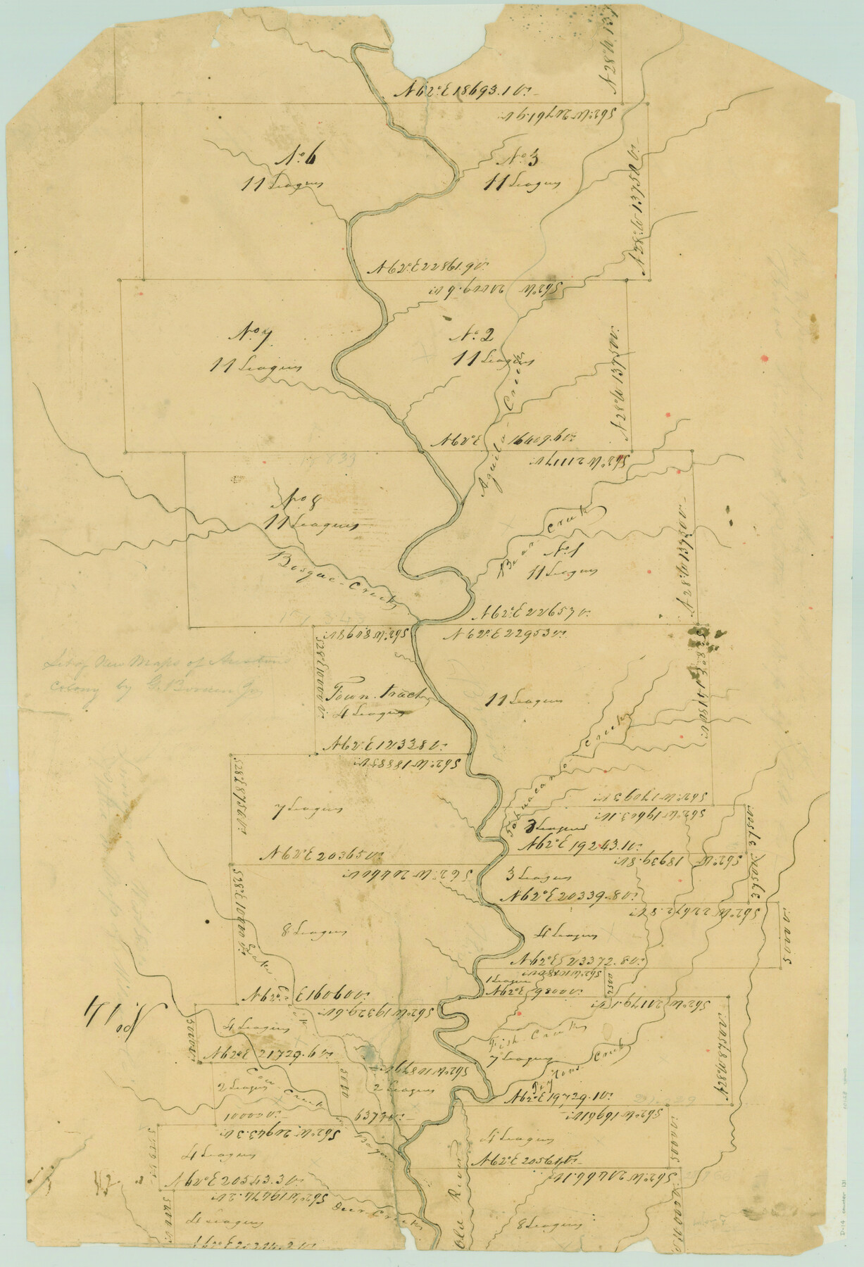
Set of new maps of Austin's Colony by G. Borden, Jr.
Atlas D, Sketch 14 (D-14)
D-14
-
Map/Doc
131
-
Collection
General Map Collection
-
Object Dates
1833 (Creation Date)
-
People and Organizations
[G. Johnson] (Surveyor/Engineer)
G. Borden Jr. (Surveyor/Engineer)
[F.W. White] (Surveyor/Engineer)
-
Counties
McLennan Falls
-
Subjects
Atlas
-
Height x Width
25.0 x 17.0 inches
63.5 x 43.2 cm
-
Medium
paper, manuscript
-
Comments
Conserved in 2004.
-
Features
Aquila Creek
Bosque Creek
Bear Creek
Tehuacano Creek
Fish Creek
Lake Creek
Cow Creek
Cow Bayou
Peytons Creeks
Old River
Deer Creek
[Brazos River]
Part of: General Map Collection
Flight Mission No. CGI-2N, Frame 185, Cameron County

Print $20.00
- Digital $50.00
Flight Mission No. CGI-2N, Frame 185, Cameron County
1954
Size 18.5 x 22.2 inches
Map/Doc 84545
Nueces County Rolled Sketch 114

Print $20.00
- Digital $50.00
Nueces County Rolled Sketch 114
1992
Size 18.1 x 24.6 inches
Map/Doc 7125
Tyler County Sketch File 2

Print $4.00
- Digital $50.00
Tyler County Sketch File 2
Size 6.3 x 5.6 inches
Map/Doc 38615
Lamb County Sketch File 5

Print $20.00
- Digital $50.00
Lamb County Sketch File 5
Size 23.3 x 31.1 inches
Map/Doc 11971
Jones County Boundary File 2

Print $6.00
- Digital $50.00
Jones County Boundary File 2
Size 12.4 x 8.3 inches
Map/Doc 55676
A Map of Sterling County

Print $20.00
- Digital $50.00
A Map of Sterling County
1919
Size 33.3 x 21.6 inches
Map/Doc 4054
Bee County Sketch File 3a

Print $8.00
- Digital $50.00
Bee County Sketch File 3a
1875
Size 12.7 x 8.2 inches
Map/Doc 14264
Irion County Sketch File 5

Print $16.00
- Digital $50.00
Irion County Sketch File 5
1900
Size 14.4 x 8.9 inches
Map/Doc 27463
Upshur County Rolled Sketch 4

Print $20.00
- Digital $50.00
Upshur County Rolled Sketch 4
1972
Size 25.4 x 37.9 inches
Map/Doc 8063

Winkler County Working Sketch 12

Print $40.00
- Digital $50.00
Winkler County Working Sketch 12
1961
Size 59.3 x 50.0 inches
Map/Doc 72606
Erath County Working Sketch 18

Print $20.00
- Digital $50.00
Erath County Working Sketch 18
1962
Size 30.5 x 34.8 inches
Map/Doc 69099
You may also like
Jeff Davis County Rolled Sketch 42

Print $20.00
- Digital $50.00
Jeff Davis County Rolled Sketch 42
1998
Size 26.8 x 18.9 inches
Map/Doc 76415
Sketch of State University Lands and Connections in El Paso Co.

Print $20.00
- Digital $50.00
Sketch of State University Lands and Connections in El Paso Co.
1900
Size 33.1 x 32.4 inches
Map/Doc 2427
Jasper County Sketch File 12a

Print $16.00
- Digital $50.00
Jasper County Sketch File 12a
1881
Size 13.0 x 8.4 inches
Map/Doc 27794
Henderson County Working Sketch 8

Print $20.00
- Digital $50.00
Henderson County Working Sketch 8
1922
Size 15.9 x 16.1 inches
Map/Doc 66141
Travis County Sketch File 28

Print $40.00
- Digital $50.00
Travis County Sketch File 28
Size 17.5 x 12.2 inches
Map/Doc 38341
Flight Mission No. BRE-1P, Frame 33, Nueces County

Print $20.00
- Digital $50.00
Flight Mission No. BRE-1P, Frame 33, Nueces County
1956
Size 18.5 x 22.2 inches
Map/Doc 86629
Mason County Sketch File 1

Print $6.00
- Digital $50.00
Mason County Sketch File 1
1857
Size 11.0 x 8.2 inches
Map/Doc 30677
[Oceani occidentalis seu terrae novae tabula]
![95835, [Oceani occidentalis seu Terre Noue Tabula Christophorus Columbus], General Map Collection](https://historictexasmaps.com/wmedia_w700/maps/95835-1.tif.jpg)
Print $20.00
- Digital $50.00
[Oceani occidentalis seu terrae novae tabula]
1535
Size 16.0 x 21.6 inches
Map/Doc 95835
Gray's railroad map of Texas.

Print $20.00
Gray's railroad map of Texas.
1878
Size 26.4 x 16.1 inches
Map/Doc 93597
Kleberg County Rolled Sketch 10-1

Print $20.00
- Digital $50.00
Kleberg County Rolled Sketch 10-1
1951
Size 36.9 x 32.2 inches
Map/Doc 9383
Edwards County Sketch File 56

Print $32.00
- Digital $50.00
Edwards County Sketch File 56
1915
Size 11.4 x 9.0 inches
Map/Doc 21808
[Sketch showing west part of county]
![91713, [Sketch showing west part of county], Twichell Survey Records](https://historictexasmaps.com/wmedia_w700/maps/91713-1.tif.jpg)
Print $20.00
- Digital $50.00
[Sketch showing west part of county]
Size 24.2 x 13.8 inches
Map/Doc 91713