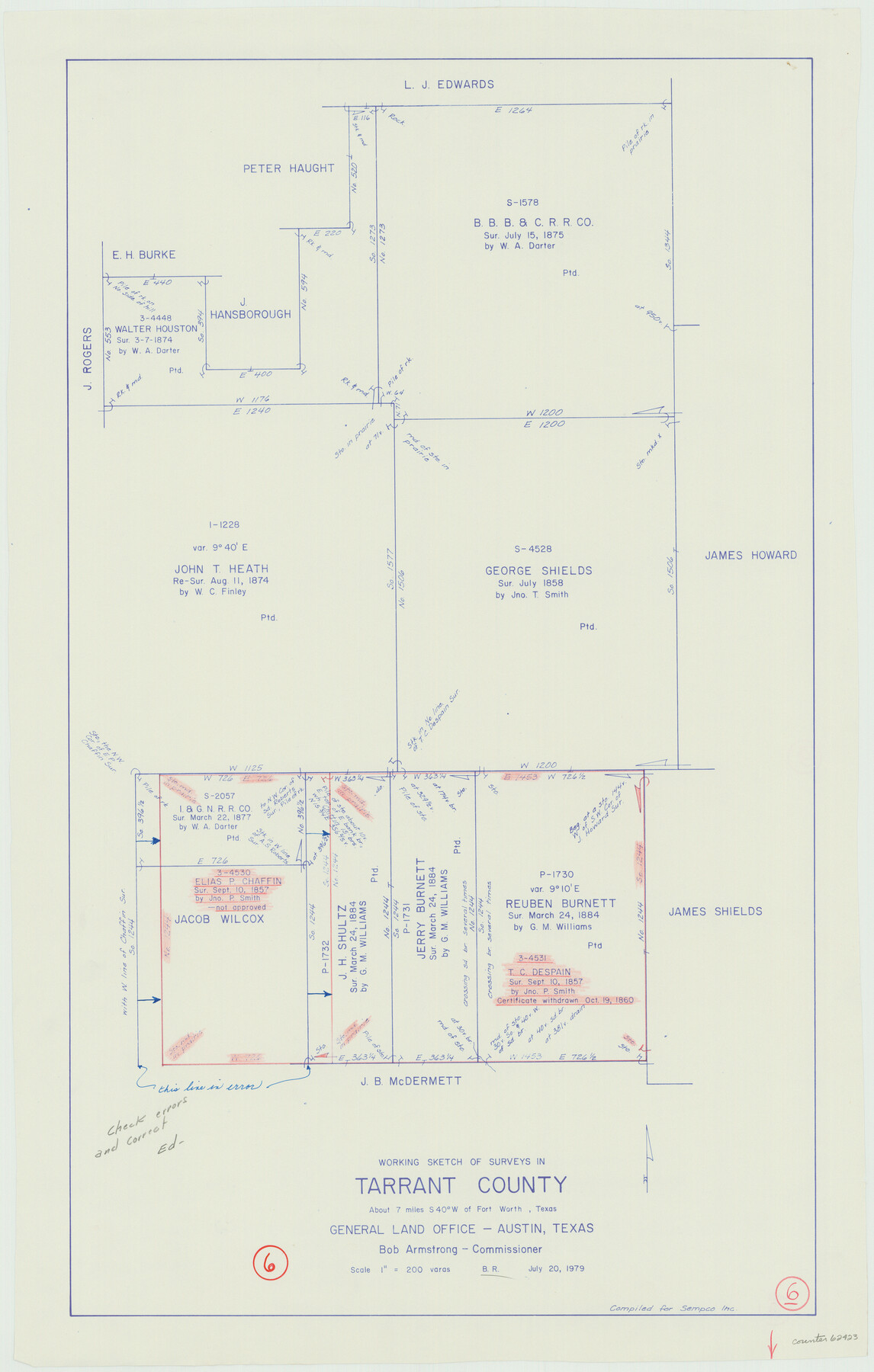
Tarrant County Working Sketch 6
-
Map/Doc
62423
-
Collection
General Map Collection
-
Object Dates
7/20/1979 (Creation Date)
-
People and Organizations
Beverly Robison (Draftsman)
-
Counties
Tarrant
-
Subjects
Surveying Working Sketch
-
Height x Width
29.3 x 18.7 inches
74.4 x 47.5 cm
-
Scale
1" = 200 varas
Part of: General Map Collection
Lynn County Sketch File 2

Print $5.00
- Digital $50.00
Lynn County Sketch File 2
1902
Size 11.6 x 17.1 inches
Map/Doc 30447
El Paso County Working Sketch 57

Print $20.00
- Digital $50.00
El Paso County Working Sketch 57
Size 37.5 x 37.4 inches
Map/Doc 69079

Kent County Sketch File 3

Print $4.00
- Digital $50.00
Kent County Sketch File 3
Size 14.2 x 8.7 inches
Map/Doc 28825
Andrews County Working Sketch 9

Print $20.00
- Digital $50.00
Andrews County Working Sketch 9
1955
Size 10.2 x 23.3 inches
Map/Doc 67055
Edwards County Rolled Sketch 21

Print $20.00
- Digital $50.00
Edwards County Rolled Sketch 21
1948
Size 17.0 x 29.4 inches
Map/Doc 5809
Terrell County Working Sketch 40

Print $20.00
- Digital $50.00
Terrell County Working Sketch 40
1956
Size 22.9 x 29.1 inches
Map/Doc 62133
United States - Gulf Coast - Padre I. and Laguna Madre Lat. 27° 12' to Lat. 26° 33' Texas

Print $20.00
- Digital $50.00
United States - Gulf Coast - Padre I. and Laguna Madre Lat. 27° 12' to Lat. 26° 33' Texas
1913
Size 26.9 x 18.2 inches
Map/Doc 72820
Map of Ramsey State Farm, Brazoria County, Texas

Print $20.00
- Digital $50.00
Map of Ramsey State Farm, Brazoria County, Texas
Size 28.7 x 36.5 inches
Map/Doc 62998
Motley County Working Sketch 9

Print $20.00
- Digital $50.00
Motley County Working Sketch 9
1984
Size 32.6 x 28.9 inches
Map/Doc 71214
Map of Lee County

Print $20.00
- Digital $50.00
Map of Lee County
1888
Size 42.1 x 39.8 inches
Map/Doc 16876
Foard County Boundary File 4

Print $24.00
- Digital $50.00
Foard County Boundary File 4
Size 14.2 x 8.8 inches
Map/Doc 53524
You may also like
Topographical Map of the Rio Grande, Sheet No. 11

Print $20.00
- Digital $50.00
Topographical Map of the Rio Grande, Sheet No. 11
1912
Map/Doc 89535
Map of the British Isles designed to accompany Smith's Geography for Schools

Print $20.00
- Digital $50.00
Map of the British Isles designed to accompany Smith's Geography for Schools
1850
Size 12.1 x 9.8 inches
Map/Doc 93894
Flight Mission No. DQN-6K, Frame 3, Calhoun County

Print $20.00
- Digital $50.00
Flight Mission No. DQN-6K, Frame 3, Calhoun County
1953
Size 18.3 x 22.1 inches
Map/Doc 84425
Intracoastal Waterway in Texas - Corpus Christi to Point Isabel including Arroyo Colorado to Mo. Pac. R.R. Bridge Near Harlingen

Print $20.00
- Digital $50.00
Intracoastal Waterway in Texas - Corpus Christi to Point Isabel including Arroyo Colorado to Mo. Pac. R.R. Bridge Near Harlingen
1933
Size 27.7 x 41.0 inches
Map/Doc 61857
Denton County Working Sketch 5

Print $20.00
- Digital $50.00
Denton County Working Sketch 5
1956
Size 23.9 x 19.4 inches
Map/Doc 68610
Triangulation Net of the United States

Print $20.00
- Digital $50.00
Triangulation Net of the United States
1938
Size 28.1 x 42.2 inches
Map/Doc 3117
Map of north end of Brazos Island

Print $20.00
- Digital $50.00
Map of north end of Brazos Island
Size 27.6 x 18.2 inches
Map/Doc 72908
Brewster County Rolled Sketch 85

Print $20.00
- Digital $50.00
Brewster County Rolled Sketch 85
1946
Size 30.4 x 22.8 inches
Map/Doc 5246
Blanco County Sketch File 1

Print $4.00
- Digital $50.00
Blanco County Sketch File 1
1874
Size 7.8 x 7.9 inches
Map/Doc 14578
Upshur County Working Sketch 4

Print $20.00
- Digital $50.00
Upshur County Working Sketch 4
1939
Size 21.6 x 15.3 inches
Map/Doc 69560
Montgomery County Working Sketch 64

Print $20.00
- Digital $50.00
Montgomery County Working Sketch 64
1965
Size 27.9 x 33.7 inches
Map/Doc 71171
Brewster County Rolled Sketch 89

Print $40.00
- Digital $50.00
Brewster County Rolled Sketch 89
1947
Size 37.3 x 63.4 inches
Map/Doc 8499