![94272, [Geological Map of the Great East Texas Oil Fields], General Map Collection](https://historictexasmaps.com/wmedia_w1800h1800/maps/94272.tif.jpg)
[Geological Map of the Great East Texas Oil Fields]
[verso] - Advertising for the Mitchell Group
-
Map/Doc
94272
-
Collection
General Map Collection
-
Object Dates
1921/4/21 (Copyright Date)
-
People and Organizations
The Mitchell Interests (Publisher)
-
Subjects
Energy Surface State of Texas
-
Height x Width
22.4 x 11.7 inches
56.9 x 29.7 cm
-
Medium
paper, etching/engraving/lithograph
-
Comments
See 94271 for map on recto.
Related maps
Geological Map of the Great East Texas Oil Fields

Print $20.00
- Digital $50.00
Geological Map of the Great East Texas Oil Fields
Size 22.6 x 11.7 inches
Map/Doc 94271
Part of: General Map Collection
Hunt County Sketch File 30

Print $6.00
- Digital $50.00
Hunt County Sketch File 30
1862
Size 8.1 x 7.5 inches
Map/Doc 27132
Knox County Rolled Sketch 23

Print $20.00
- Digital $50.00
Knox County Rolled Sketch 23
1989
Size 34.4 x 29.0 inches
Map/Doc 76408
Jackson County Sketch File 4

Print $20.00
- Digital $50.00
Jackson County Sketch File 4
Size 18.2 x 22.7 inches
Map/Doc 11834
Galveston Bay Entrance - Galveston and Texas City Harbors

Print $40.00
- Digital $50.00
Galveston Bay Entrance - Galveston and Texas City Harbors
1971
Size 33.4 x 50.1 inches
Map/Doc 69861
Montgomery County Sketch File 6b

Print $40.00
- Digital $50.00
Montgomery County Sketch File 6b
Size 12.8 x 16.2 inches
Map/Doc 31783
Southern Pacific R.R. and connections

Print $20.00
- Digital $50.00
Southern Pacific R.R. and connections
1883
Size 27.9 x 32.5 inches
Map/Doc 94270
Hopkins County Sketch File 24

Print $4.00
- Digital $50.00
Hopkins County Sketch File 24
1871
Size 12.8 x 8.4 inches
Map/Doc 26734
[Atchison, Topeka & Santa Fe from Paisano to south of Plata]
![64709, [Atchison, Topeka & Santa Fe from Paisano to south of Plata], General Map Collection](https://historictexasmaps.com/wmedia_w700/maps/64709.tif.jpg)
Print $40.00
- Digital $50.00
[Atchison, Topeka & Santa Fe from Paisano to south of Plata]
Size 32.3 x 120.8 inches
Map/Doc 64709
Flight Mission No. DIX-8P, Frame 75, Aransas County

Print $20.00
- Digital $50.00
Flight Mission No. DIX-8P, Frame 75, Aransas County
1956
Size 18.9 x 22.3 inches
Map/Doc 83906
Reeves County Rolled Sketch 34

Print $20.00
- Digital $50.00
Reeves County Rolled Sketch 34
Size 35.4 x 24.1 inches
Map/Doc 78490
Brewster County Rolled Sketch 146B

Print $40.00
- Digital $50.00
Brewster County Rolled Sketch 146B
1985
Size 55.5 x 45.2 inches
Map/Doc 8528
Presidio County Working Sketch Graphic Index, Northeast Part

Print $20.00
- Digital $50.00
Presidio County Working Sketch Graphic Index, Northeast Part
1973
Size 40.3 x 32.2 inches
Map/Doc 76674
You may also like
Armstrong County Sketch File 3

Print $40.00
- Digital $50.00
Armstrong County Sketch File 3
1883
Size 27.4 x 29.4 inches
Map/Doc 10839
Reeves County Working Sketch 7

Print $20.00
- Digital $50.00
Reeves County Working Sketch 7
Size 36.7 x 43.9 inches
Map/Doc 63450
Shackelford County Boundary File 5

Print $14.00
- Digital $50.00
Shackelford County Boundary File 5
Size 8.6 x 14.0 inches
Map/Doc 58661
Wise County Working Sketch 1

Print $20.00
- Digital $50.00
Wise County Working Sketch 1
Size 22.4 x 19.4 inches
Map/Doc 72615
Harris County Working Sketch 6

Print $20.00
- Digital $50.00
Harris County Working Sketch 6
1905
Size 20.4 x 12.1 inches
Map/Doc 65898
El Paso County Working Sketch 11

Print $40.00
- Digital $50.00
El Paso County Working Sketch 11
1955
Size 49.2 x 43.4 inches
Map/Doc 69033
Stonewall County Working Sketch 33

Print $40.00
- Digital $50.00
Stonewall County Working Sketch 33
Size 70.4 x 42.8 inches
Map/Doc 62340
Garza County Working Sketch 4

Print $20.00
- Digital $50.00
Garza County Working Sketch 4
1916
Size 19.5 x 23.1 inches
Map/Doc 63151
Map of Ochiltree County, Texas

Print $20.00
- Digital $50.00
Map of Ochiltree County, Texas
Size 17.9 x 14.6 inches
Map/Doc 4610
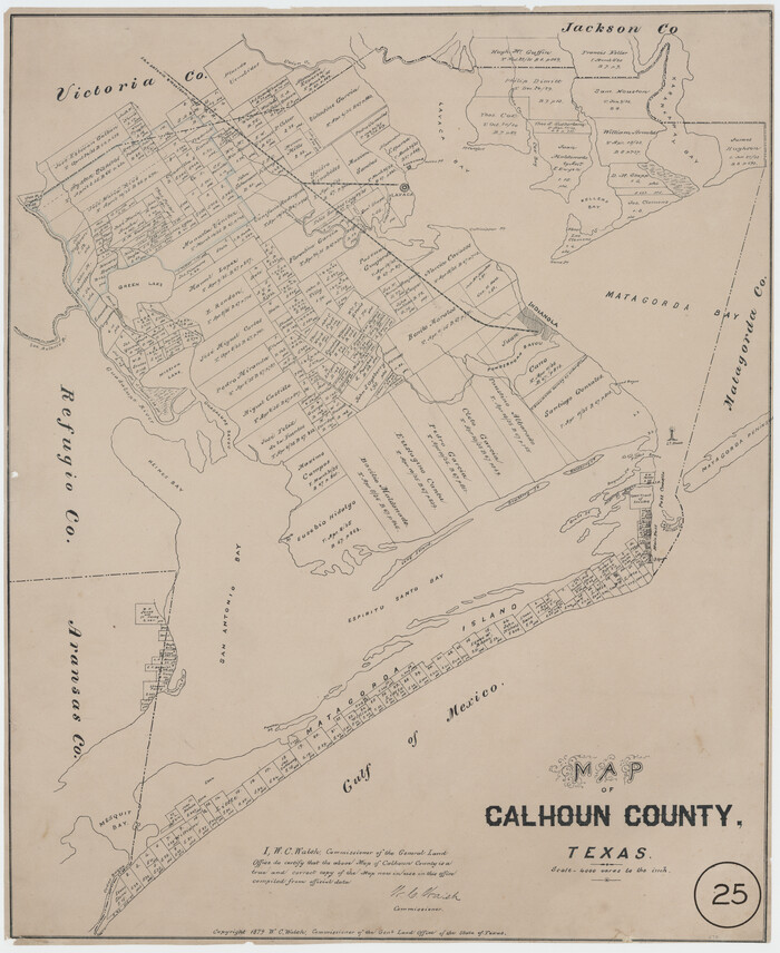
Map of Calhoun County, Texas
Print $20.00
- Digital $50.00
Map of Calhoun County, Texas
1879
Size 22.8 x 18.7 inches
Map/Doc 670
Liberty County Working Sketch 17

Print $20.00
- Digital $50.00
Liberty County Working Sketch 17
1934
Size 34.5 x 24.0 inches
Map/Doc 70476
Liberty County Sketch File 16

Print $4.00
- Digital $50.00
Liberty County Sketch File 16
1859
Size 11.4 x 6.7 inches
Map/Doc 29917