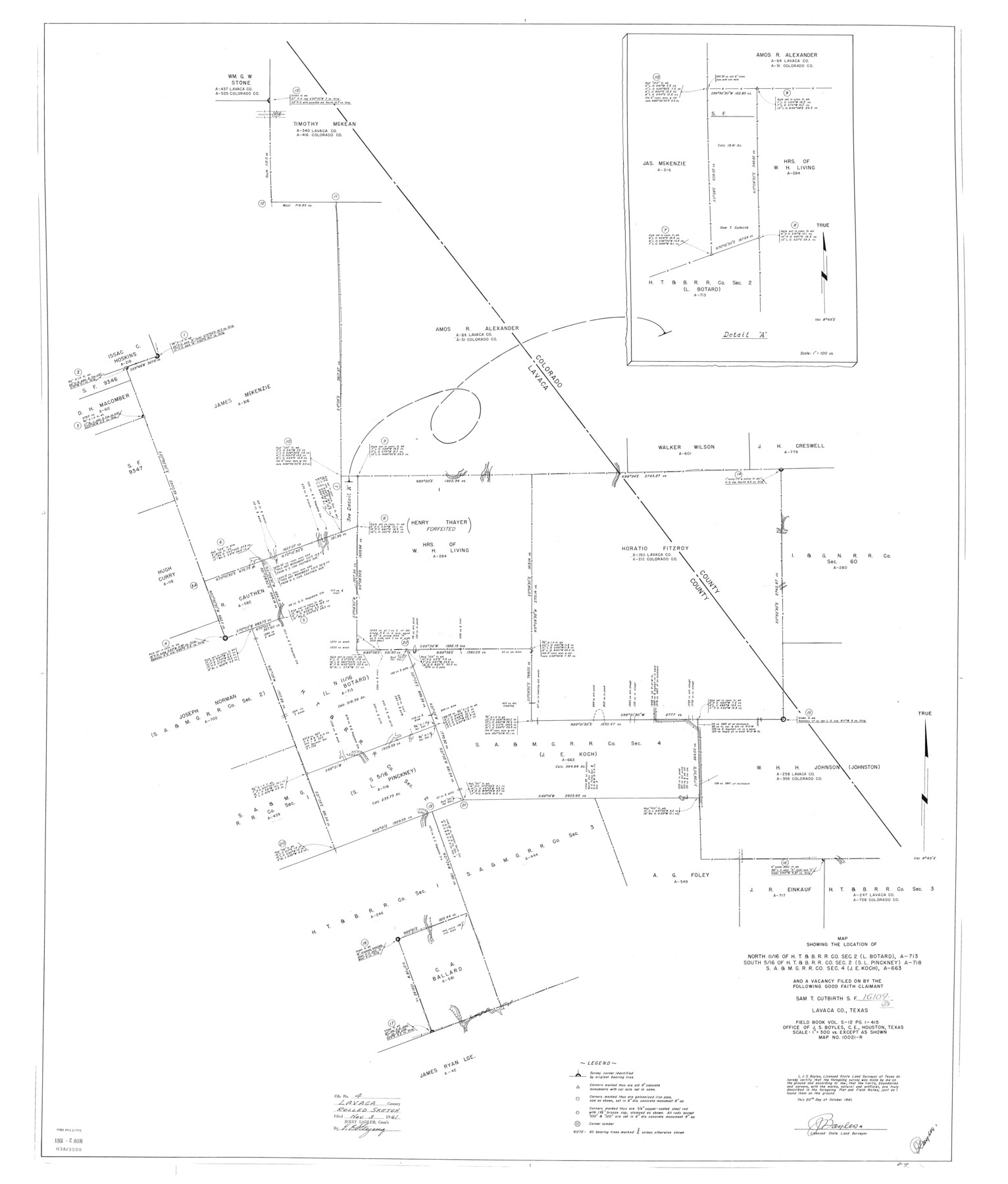
Lavaca County Rolled Sketch 4
Map showing the location of north 11/16 of H. T. & B. R.R. Co. sec. 2 (L. Botard), A-713, south 5/16 of H. T. & B. R.R. Co. sec. 2 (S.L. Pinckney) A-718, S. A. & M. G. R.R. Co. sec. 4 (J.E. Koch), A-663
-
Map/Doc
9420
-
Collection
General Map Collection
-
Object Dates
1961/10/20 (Creation Date)
1961/11/3 (File Date)
-
People and Organizations
J.S. Boyles (Surveyor/Engineer)
-
Counties
Lavaca Colorado
-
Subjects
Surveying Rolled Sketch
-
Height x Width
43.6 x 37.1 inches
110.7 x 94.2 cm
-
Scale
1" = 300 varas
-
Comments
See SF-16109.
Part of: General Map Collection
Crane County Working Sketch 20

Print $40.00
- Digital $50.00
Crane County Working Sketch 20
1958
Size 61.8 x 38.1 inches
Map/Doc 68297
A New Map of Texas with the contiguous American and Mexican States

Print $20.00
- Digital $50.00
A New Map of Texas with the contiguous American and Mexican States
1839
Size 13.0 x 15.4 inches
Map/Doc 96513

Flight Mission No. DAG-23K, Frame 151, Matagorda County

Print $20.00
- Digital $50.00
Flight Mission No. DAG-23K, Frame 151, Matagorda County
1953
Size 15.9 x 15.8 inches
Map/Doc 86499
Gulf Intracoastal Waterway - Aransas Bay to Corpus Christi Bay, Modified Route of Main Channel Location of Spoil Disposal Areas

Print $20.00
- Digital $50.00
Gulf Intracoastal Waterway - Aransas Bay to Corpus Christi Bay, Modified Route of Main Channel Location of Spoil Disposal Areas
1961
Size 31.4 x 42.1 inches
Map/Doc 61829
Sutton County Boundary File 4a

Print $4.00
- Digital $50.00
Sutton County Boundary File 4a
Size 10.7 x 8.4 inches
Map/Doc 59045
Flight Mission No. DAG-24K, Frame 38, Matagorda County

Print $20.00
- Digital $50.00
Flight Mission No. DAG-24K, Frame 38, Matagorda County
1953
Size 18.5 x 15.8 inches
Map/Doc 86525
Harris County Sketch File 18

Print $6.00
- Digital $50.00
Harris County Sketch File 18
1860
Size 8.0 x 3.4 inches
Map/Doc 25363
Armstrong County Sketch File 8

Print $8.00
- Digital $50.00
Armstrong County Sketch File 8
Size 14.2 x 8.8 inches
Map/Doc 13705
Dallas County Working Sketch 9

Print $20.00
- Digital $50.00
Dallas County Working Sketch 9
1960
Size 23.1 x 20.0 inches
Map/Doc 68575
Coke County Working Sketch 30

Print $20.00
- Digital $50.00
Coke County Working Sketch 30
1982
Size 15.7 x 22.4 inches
Map/Doc 76064
[Abstract Numbering Register - Real through Zavala]
![82968, [Abstract Numbering Register - Real through Zavala], General Map Collection](https://historictexasmaps.com/wmedia_w700/pdf_converted_jpg/qi_pdf_thumbnail_30615.jpg)
[Abstract Numbering Register - Real through Zavala]
Map/Doc 82968
You may also like
Montague County Working Sketch 35

Print $20.00
- Digital $50.00
Montague County Working Sketch 35
1980
Size 24.8 x 31.9 inches
Map/Doc 71101
[Sketch for Mineral Application 11108 - Greens Bayou]
![2786, [Sketch for Mineral Application 11108 - Greens Bayou], General Map Collection](https://historictexasmaps.com/wmedia_w700/maps/2786-1.tif.jpg)
Print $20.00
- Digital $50.00
[Sketch for Mineral Application 11108 - Greens Bayou]
1922
Size 46.0 x 21.0 inches
Map/Doc 2786
Gregg County Working Sketch 25

Print $20.00
- Digital $50.00
Gregg County Working Sketch 25
2006
Size 22.6 x 34.0 inches
Map/Doc 83095

Brewster County Rolled Sketch 151

Print $20.00
- Digital $50.00
Brewster County Rolled Sketch 151
1996
Size 36.3 x 28.0 inches
Map/Doc 5318
San Augustine County Working Sketch 1

Print $3.00
- Digital $50.00
San Augustine County Working Sketch 1
1906
Size 9.1 x 11.3 inches
Map/Doc 63688
Nacogdoches County Sketch File 21

Print $20.00
- Digital $50.00
Nacogdoches County Sketch File 21
1837
Size 9.4 x 5.5 inches
Map/Doc 32286
Hamilton County Boundary File 6

Print $4.00
- Digital $50.00
Hamilton County Boundary File 6
Size 11.2 x 8.6 inches
Map/Doc 54225
Val Verde Co.

Print $20.00
- Digital $50.00
Val Verde Co.
1908
Size 39.8 x 38.7 inches
Map/Doc 63100
Map of Mason County

Print $20.00
- Digital $50.00
Map of Mason County
1877
Size 25.3 x 19.9 inches
Map/Doc 3836
Brewster County Working Sketch 111

Print $40.00
- Digital $50.00
Brewster County Working Sketch 111
1982
Size 21.5 x 55.9 inches
Map/Doc 67711
Map of Louisiana, Texas, Arkansas and Indian Territory

Print $20.00
- Digital $50.00
Map of Louisiana, Texas, Arkansas and Indian Territory
1885
Size 9.0 x 12.2 inches
Map/Doc 93519