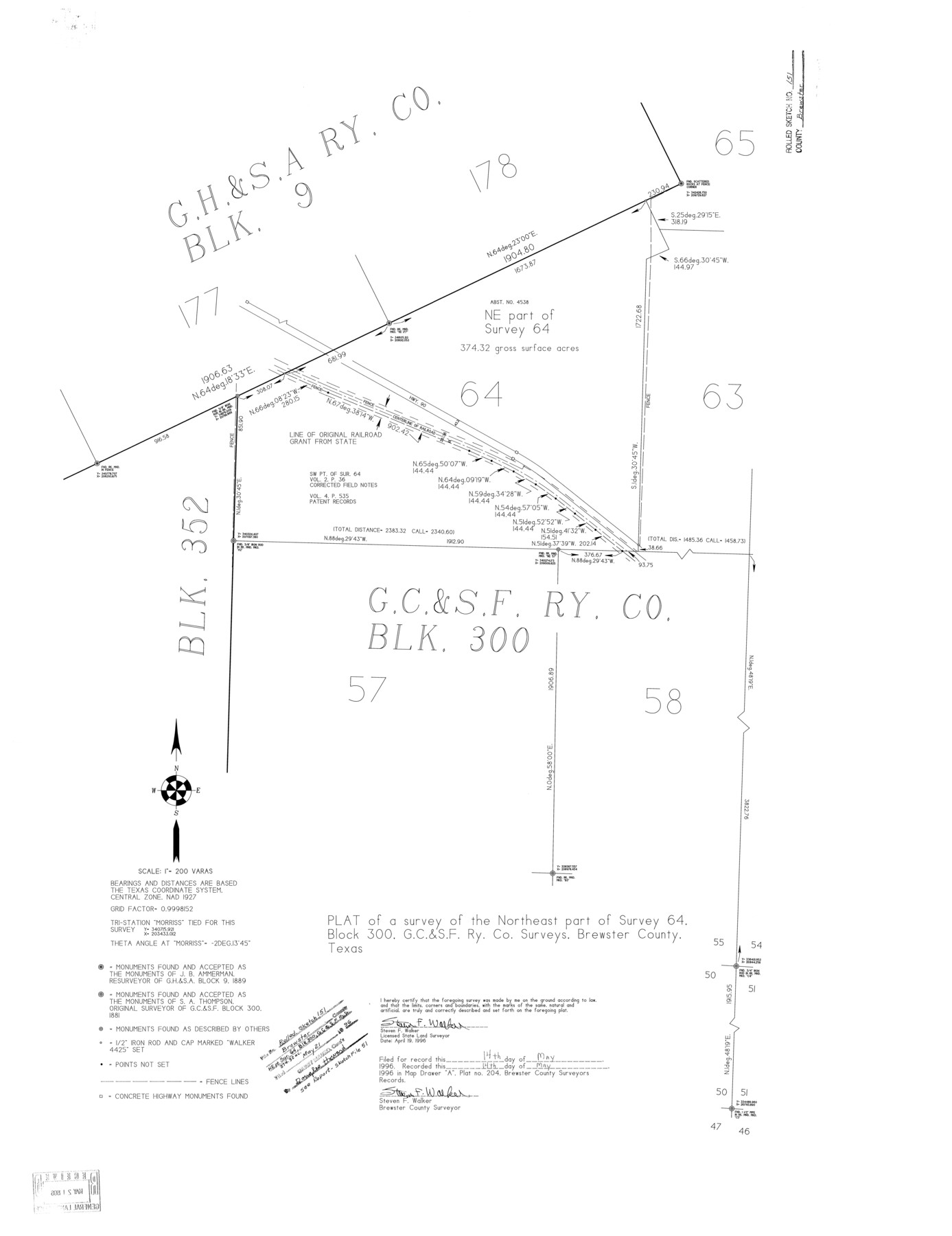
Brewster County Rolled Sketch 151
Plat of a survey of the northeast part of survey 64, Block 300, G. C. & S. F. Ry. Co. surveys
-
Map/Doc
5318
-
Collection
General Map Collection
-
Object Dates
1996/4/19 (Creation Date)
1996/5/21 (File Date)
-
People and Organizations
Steven F. Walker (Surveyor/Engineer)
-
Counties
Brewster
-
Subjects
Surveying Rolled Sketch
-
Height x Width
36.3 x 28.0 inches
92.2 x 71.1 cm
-
Medium
mylar, print
-
Scale
1" = 200 varas
-
Comments
See Brewster County Sketch File 51 (16352) for surveyor’s report.
Related maps
Brewster County Sketch File 51

Print $20.00
- Digital $50.00
Brewster County Sketch File 51
1996
Size 13.8 x 8.3 inches
Map/Doc 16352
Part of: General Map Collection
Loving County Rolled Sketch 4

Print $40.00
- Digital $50.00
Loving County Rolled Sketch 4
1952
Size 82.2 x 19.5 inches
Map/Doc 9465
Colton's "New Medium" Map of the State of Texas, the Indian Territory, etc. from the latest & most authentic sources

Print $20.00
- Digital $50.00
Colton's "New Medium" Map of the State of Texas, the Indian Territory, etc. from the latest & most authentic sources
1884
Size 25.4 x 29.5 inches
Map/Doc 96524
El Paso County Working Sketch 11

Print $40.00
- Digital $50.00
El Paso County Working Sketch 11
1955
Size 49.2 x 43.4 inches
Map/Doc 69033
San Jacinto County Rolled Sketch 14

Print $20.00
- Digital $50.00
San Jacinto County Rolled Sketch 14
1998
Size 26.5 x 37.3 inches
Map/Doc 7568
Williamson County Sketch File 18

Print $6.00
- Digital $50.00
Williamson County Sketch File 18
1871
Size 12.8 x 8.1 inches
Map/Doc 40342
Controlled Mosaic by Jack Amman Photogrammetric Engineers, Inc - Sheet 13

Print $20.00
- Digital $50.00
Controlled Mosaic by Jack Amman Photogrammetric Engineers, Inc - Sheet 13
1954
Size 20.0 x 24.0 inches
Map/Doc 83457

Hemphill County Working Sketch 6

Print $20.00
- Digital $50.00
Hemphill County Working Sketch 6
1950
Size 20.3 x 27.0 inches
Map/Doc 66101
Blanco County Sketch File 5

Print $4.00
- Digital $50.00
Blanco County Sketch File 5
1860
Size 9.3 x 8.3 inches
Map/Doc 14582
Liberty County Working Sketch 57

Print $40.00
- Digital $50.00
Liberty County Working Sketch 57
1967
Size 52.6 x 40.6 inches
Map/Doc 70517
Gonzales County

Print $20.00
- Digital $50.00
Gonzales County
1869
Size 22.2 x 22.1 inches
Map/Doc 3592
Harrison County Working Sketch 20

Print $20.00
- Digital $50.00
Harrison County Working Sketch 20
1979
Size 15.3 x 19.5 inches
Map/Doc 66040
You may also like


Moore County Sketch File 12

Print $20.00
- Digital $50.00
Moore County Sketch File 12
1939
Size 27.3 x 19.9 inches
Map/Doc 42130
Carson County Boundary File 2

Print $56.00
- Digital $50.00
Carson County Boundary File 2
Size 14.0 x 8.6 inches
Map/Doc 51121
[Block RG, Sections 1, 2, and 16, North Line of San Augustine County School Land]
![91392, [Block RG, Sections 1, 2, and 16, North Line of San Augustine County School Land], Twichell Survey Records](https://historictexasmaps.com/wmedia_w700/maps/91392-1.tif.jpg)
Print $20.00
- Digital $50.00
[Block RG, Sections 1, 2, and 16, North Line of San Augustine County School Land]
Size 25.7 x 12.4 inches
Map/Doc 91392
Sabine River, Composite Sheet

Print $40.00
- Digital $50.00
Sabine River, Composite Sheet
Size 38.5 x 52.7 inches
Map/Doc 65133
Hemphill County

Print $20.00
- Digital $50.00
Hemphill County
1888
Size 23.9 x 18.3 inches
Map/Doc 3653
Kent County Working Sketch 25

Print $20.00
- Digital $50.00
Kent County Working Sketch 25
1989
Size 18.8 x 18.5 inches
Map/Doc 69641
Flight Mission No. DQN-7K, Frame 10, Calhoun County

Print $20.00
- Digital $50.00
Flight Mission No. DQN-7K, Frame 10, Calhoun County
1953
Size 18.1 x 22.1 inches
Map/Doc 84461
Uvalde County Sketch File A

Print $40.00
- Digital $50.00
Uvalde County Sketch File A
1912
Size 23.0 x 18.0 inches
Map/Doc 12537
Terrell County Working Sketch 68

Print $20.00
- Digital $50.00
Terrell County Working Sketch 68
1973
Size 43.7 x 26.4 inches
Map/Doc 69589
McMullen County Working Sketch 26

Print $20.00
- Digital $50.00
McMullen County Working Sketch 26
1953
Size 17.8 x 14.5 inches
Map/Doc 70727