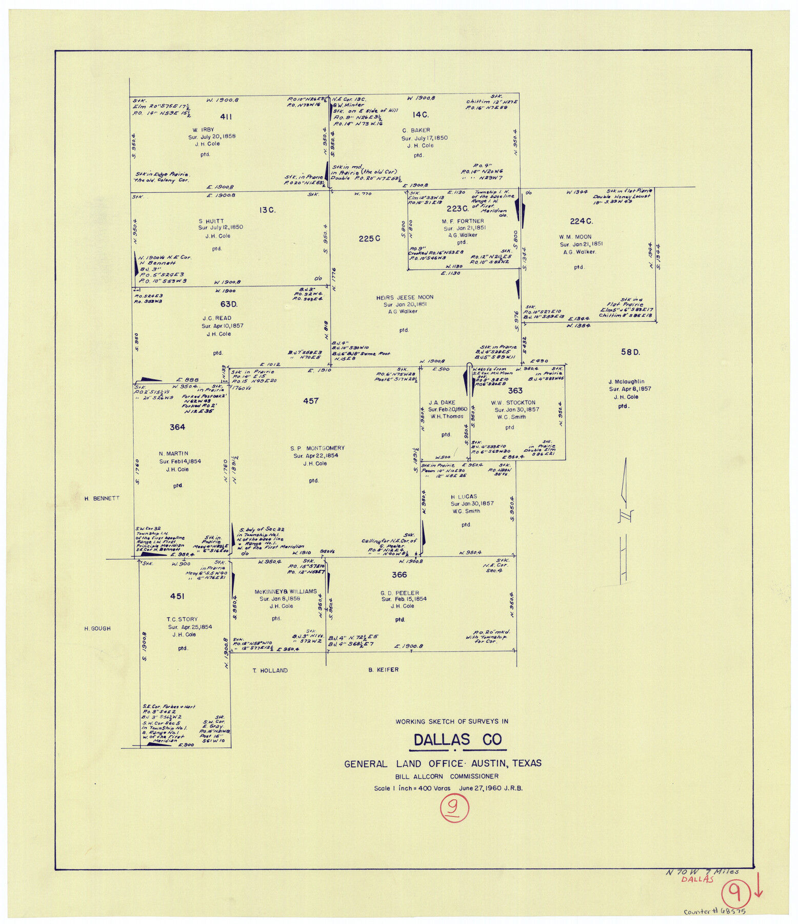
Dallas County Working Sketch 9
-
Map/Doc
68575
-
Collection
General Map Collection
-
Object Dates
6/27/1960 (Creation Date)
-
Counties
Dallas
-
Subjects
Surveying Working Sketch
-
Height x Width
23.1 x 20.0 inches
58.7 x 50.8 cm
-
Scale
1" = 400 varas
Part of: General Map Collection
Flight Mission No. DCL-7C, Frame 11, Kenedy County

Print $20.00
- Digital $50.00
Flight Mission No. DCL-7C, Frame 11, Kenedy County
1943
Size 15.4 x 15.2 inches
Map/Doc 86003
Map of Madison County

Print $20.00
- Digital $50.00
Map of Madison County
1880
Size 17.0 x 24.9 inches
Map/Doc 3832
Jasper County Sketch File 29

Print $20.00
- Digital $50.00
Jasper County Sketch File 29
1947
Size 21.0 x 24.8 inches
Map/Doc 11851
Baylor County Sketch File 32

Print $10.00
- Digital $50.00
Baylor County Sketch File 32
Size 10.2 x 8.2 inches
Map/Doc 14238
Duval County Sketch File 6b

Print $5.00
- Digital $50.00
Duval County Sketch File 6b
1875
Size 8.3 x 10.8 inches
Map/Doc 21290
Upton County Rolled Sketch 47

Print $20.00
- Digital $50.00
Upton County Rolled Sketch 47
1937
Size 22.6 x 35.3 inches
Map/Doc 8083

Midland County Boundary File 5

Print $6.00
- Digital $50.00
Midland County Boundary File 5
Size 9.6 x 6.0 inches
Map/Doc 57195
Calhoun County Rolled Sketch 28B

Print $7.00
- Digital $50.00
Calhoun County Rolled Sketch 28B
1834
Size 10.5 x 15.4 inches
Map/Doc 43684
Comanche County Sketch File 13

Print $4.00
- Digital $50.00
Comanche County Sketch File 13
Size 8.5 x 8.6 inches
Map/Doc 19076
Map of Red River County

Print $20.00
- Digital $50.00
Map of Red River County
1842
Size 25.2 x 23.1 inches
Map/Doc 78369

You may also like
Morris County Rolled Sketch 2A

Print $20.00
- Digital $50.00
Morris County Rolled Sketch 2A
Size 24.4 x 19.4 inches
Map/Doc 10245
Falls County Sketch File 24

Print $4.00
- Digital $50.00
Falls County Sketch File 24
1859
Size 13.1 x 8.2 inches
Map/Doc 22428
Panola County Working Sketch 12

Print $20.00
- Digital $50.00
Panola County Working Sketch 12
1945
Map/Doc 71421
Flight Mission No. BQR-5K, Frame 64, Brazoria County

Print $20.00
- Digital $50.00
Flight Mission No. BQR-5K, Frame 64, Brazoria County
1952
Size 18.8 x 22.5 inches
Map/Doc 84009
Titus County Working Sketch 4

Print $20.00
- Digital $50.00
Titus County Working Sketch 4
1955
Size 24.3 x 20.4 inches
Map/Doc 69365
Pecos County Sketch File 38

Print $4.00
- Digital $50.00
Pecos County Sketch File 38
1895
Size 11.3 x 8.8 inches
Map/Doc 33720
Engineer map showing engineer information at 23 O'Clock 23 Oct. 1918 drawn under direction of Col. W.A. Mitchell - Verso

Print $20.00
Engineer map showing engineer information at 23 O'Clock 23 Oct. 1918 drawn under direction of Col. W.A. Mitchell - Verso
1918
Size 19.7 x 12.6 inches
Map/Doc 94128
Flight Mission No. CUG-2P, Frame 9, Kleberg County

Print $20.00
- Digital $50.00
Flight Mission No. CUG-2P, Frame 9, Kleberg County
1956
Size 18.6 x 22.2 inches
Map/Doc 86181
Williamson County

Print $20.00
- Digital $50.00
Williamson County
1919
Size 22.5 x 29.8 inches
Map/Doc 4643
Port Series No. 6 - The Ports of Galveston, Houston, and Texas City, Texas

Port Series No. 6 - The Ports of Galveston, Houston, and Texas City, Texas
1924
Map/Doc 97159
Texas, Aransas Bay, Aransas Pass to Nine Mile Point

Print $40.00
- Digital $50.00
Texas, Aransas Bay, Aransas Pass to Nine Mile Point
1934
Size 35.2 x 48.4 inches
Map/Doc 73431
[Cotton Belt, St. Louis Southwestern Railway of Texas, Alignment through Smith County]
![64374, [Cotton Belt, St. Louis Southwestern Railway of Texas, Alignment through Smith County], General Map Collection](https://historictexasmaps.com/wmedia_w700/maps/64374.tif.jpg)
Print $20.00
- Digital $50.00
[Cotton Belt, St. Louis Southwestern Railway of Texas, Alignment through Smith County]
1903
Size 21.5 x 29.3 inches
Map/Doc 64374