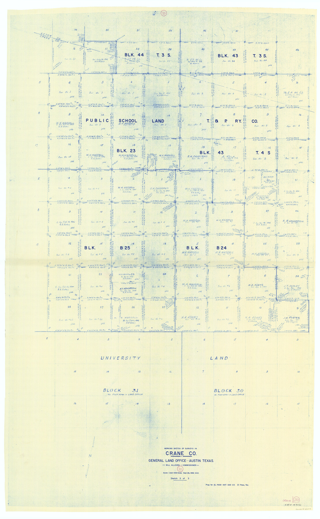
Crane County Working Sketch 20
-
Map/Doc
68297
-
Collection
General Map Collection
-
Object Dates
9/26/1958 (Creation Date)
-
People and Organizations
Otto G. Kurio (Draftsman)
-
Counties
Crane
-
Subjects
Surveying Working Sketch
-
Height x Width
61.8 x 38.1 inches
157.0 x 96.8 cm
-
Scale
1" = 500 varas
Part of: General Map Collection
Van Zandt County Sketch File 20

Print $4.00
- Digital $50.00
Van Zandt County Sketch File 20
1858
Size 12.1 x 7.9 inches
Map/Doc 39426
Flight Mission No. CRC-4R, Frame 163, Chambers County

Print $20.00
- Digital $50.00
Flight Mission No. CRC-4R, Frame 163, Chambers County
1956
Size 18.5 x 22.4 inches
Map/Doc 84922
Travis County State Real Property Sketch 8

Print $20.00
- Digital $50.00
Travis County State Real Property Sketch 8
1996
Size 30.5 x 42.6 inches
Map/Doc 77192
Harrison County Working Sketch 15

Print $20.00
- Digital $50.00
Harrison County Working Sketch 15
1961
Size 25.7 x 18.0 inches
Map/Doc 66035

Harris County NRC Article 33.136 Sketch 19

Print $50.00
- Digital $50.00
Harris County NRC Article 33.136 Sketch 19
2014
Size 24.6 x 36.6 inches
Map/Doc 95334
Eastland County Working Sketch 61

Print $20.00
- Digital $50.00
Eastland County Working Sketch 61
1989
Size 35.4 x 41.0 inches
Map/Doc 68842
Brewster County Rolled Sketch 95

Print $20.00
- Digital $50.00
Brewster County Rolled Sketch 95
1947
Size 29.4 x 38.0 inches
Map/Doc 5252
Shackelford County Sketch File 7

Print $20.00
- Digital $50.00
Shackelford County Sketch File 7
1912
Size 27.2 x 13.5 inches
Map/Doc 12314

Shelby County Working Sketch 3

Print $20.00
- Digital $50.00
Shelby County Working Sketch 3
1940
Size 28.9 x 19.4 inches
Map/Doc 63856
Val Verde County Working Sketch 22

Print $20.00
- Digital $50.00
Val Verde County Working Sketch 22
1931
Size 27.6 x 33.0 inches
Map/Doc 72157
You may also like

[H. T. & B. RR. Company, Block 10]
![91397, [H. T. & B. RR. Company, Block 10], Twichell Survey Records](https://historictexasmaps.com/wmedia_w700/maps/91397-1.tif.jpg)
Print $20.00
- Digital $50.00
[H. T. & B. RR. Company, Block 10]
Size 18.3 x 4.0 inches
Map/Doc 91397
Kaufman County Sketch File 5

Print $22.00
- Digital $50.00
Kaufman County Sketch File 5
1849
Size 7.6 x 12.6 inches
Map/Doc 28632
Real County Working Sketch 24

Print $20.00
- Digital $50.00
Real County Working Sketch 24
1946
Size 17.4 x 22.5 inches
Map/Doc 71916
Lampasas County Sketch File A

Print $4.00
- Digital $50.00
Lampasas County Sketch File A
1887
Size 11.3 x 9.0 inches
Map/Doc 29383
Kendall County Sketch File 29

Print $14.00
- Digital $50.00
Kendall County Sketch File 29
1990
Size 14.0 x 8.5 inches
Map/Doc 95291
Presidio County Rolled Sketch 83A

Print $20.00
- Digital $50.00
Presidio County Rolled Sketch 83A
1930
Size 28.2 x 27.6 inches
Map/Doc 7370
Bandera County Working Sketch 13

Print $20.00
- Digital $50.00
Bandera County Working Sketch 13
1932
Size 29.1 x 25.3 inches
Map/Doc 67606
San Augustine County Sketch File 5

Print $4.00
San Augustine County Sketch File 5
1858
Size 10.1 x 8.2 inches
Map/Doc 35642
Brazoria County Aerial Photograph Index Sheet 7

Print $20.00
- Digital $50.00
Brazoria County Aerial Photograph Index Sheet 7
1953
Size 23.9 x 19.8 inches
Map/Doc 83669
Randall County Sketch File 8

Print $20.00
- Digital $50.00
Randall County Sketch File 8
Size 18.1 x 23.1 inches
Map/Doc 12209
Crockett County Rolled Sketch 88M

Print $20.00
- Digital $50.00
Crockett County Rolled Sketch 88M
1964
Size 25.2 x 34.2 inches
Map/Doc 5629