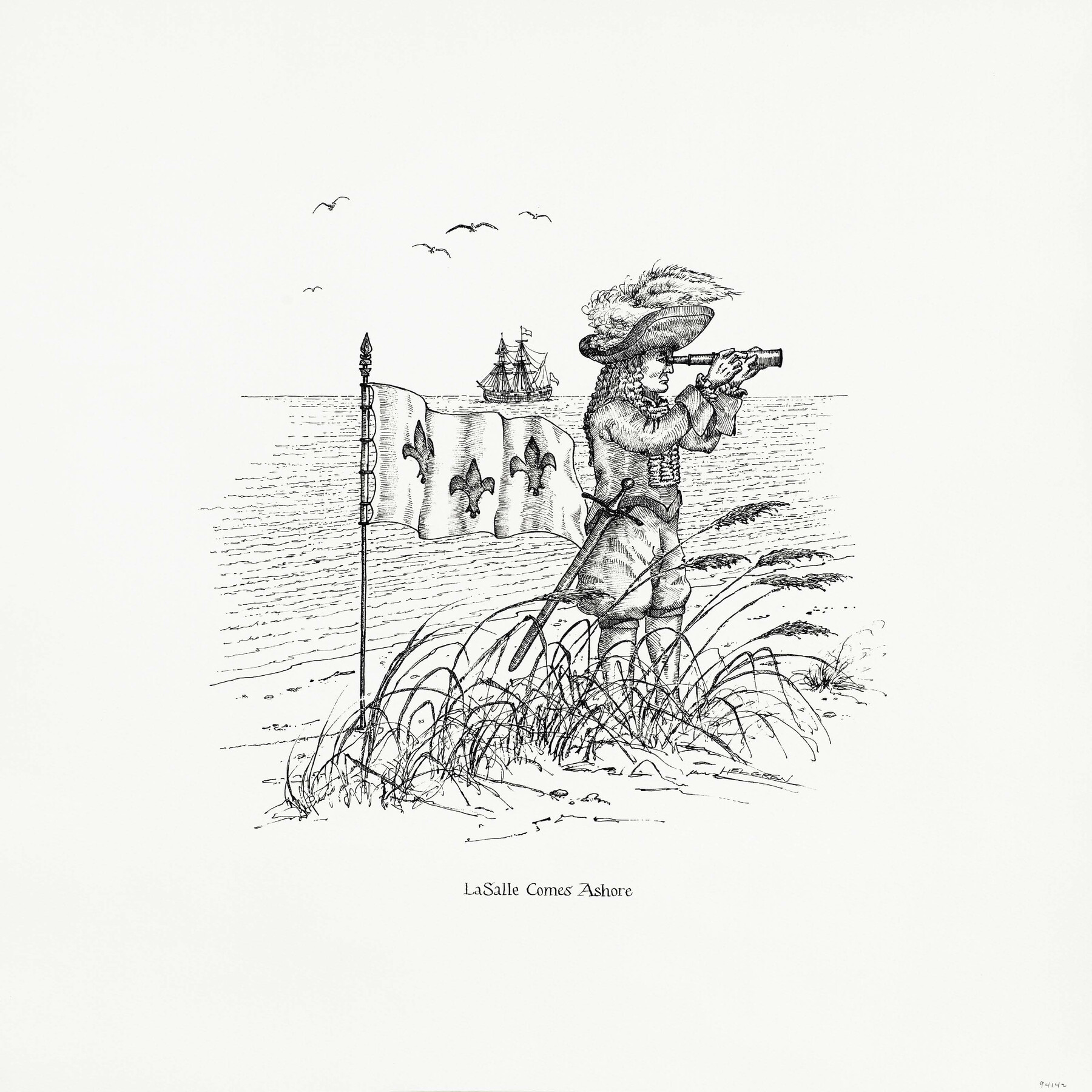
"LaSalle Comes Ashore"
-
Map/Doc
94142
-
Collection
Save Texas History Collectibles
-
People and Organizations
Texas General Land Office (Publisher)
Kenneth Helgren (Illustrator)
-
Subjects
Pictorial
-
Height x Width
20.0 x 16.0 inches
50.8 x 40.6 cm
-
Medium
paper, print
-
Comments
Artwork created by Kenneth Helgren for the "Great Military Map of Texas" (Map 83432)
Related maps
Texas Land Commissioner Jerry Patterson's Great Military Map of Texas showing Significant Conflicts and Events between 1685 and 1916

Print $20.00
- Digital $50.00
Texas Land Commissioner Jerry Patterson's Great Military Map of Texas showing Significant Conflicts and Events between 1685 and 1916
2006
Size 36.7 x 24.8 inches
Map/Doc 83432
Part of: Save Texas History Collectibles
The Compass Rose of Austin's Colony

Price $20.00
The Compass Rose of Austin's Colony
2016
Size 4.0 x 3.5 inches
Map/Doc 94443
Energy Map of Texas Ornament

Price $20.00
Energy Map of Texas Ornament
2021
Size 2.5 x 2.5 inches
Map/Doc 96574
Lay's Eagle of the United States

Price $20.00
Lay's Eagle of the United States
2020
Size 3.6 x 4.9 inches
Map/Doc 95952
Commemorative Poster: "Onward was the cry!" the 175th Anniversary of the Texas Revolution

Price $5.00
Commemorative Poster: "Onward was the cry!" the 175th Anniversary of the Texas Revolution
2011
Size 20.0 x 16.0 inches
Map/Doc 97132


2026 Save Texas History™ Map Calendar
.jpg)
Price $5.00
2026 Save Texas History™ Map Calendar
2025
Size 11.0 x 8.5 inches
Map/Doc 97491
The Yellow Rose Compass

Price $20.00
The Yellow Rose Compass
2025
Size 3.5 x 2.8 inches
Map/Doc 97508

Bien & Sterner’s New Rail Road Map of the United States

Price $20.00
Bien & Sterner’s New Rail Road Map of the United States
2022
Size 3.6 x 4.9 inches
Map/Doc 97020

You may also like
Map of Independence Area, Washington County, Texas

Print $20.00
- Digital $50.00
Map of Independence Area, Washington County, Texas
1935
Size 28.9 x 26.0 inches
Map/Doc 91990
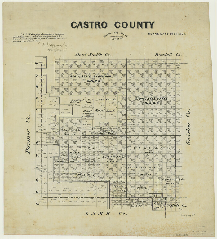
Castro County
Print $20.00
- Digital $50.00
Castro County
1891
Size 25.4 x 23.1 inches
Map/Doc 66750
Terry County Sketch

Print $20.00
- Digital $50.00
Terry County Sketch
1954
Size 13.7 x 20.6 inches
Map/Doc 92413
Frio County Sketch File 21

Print $20.00
- Digital $50.00
Frio County Sketch File 21
1938
Size 23.4 x 24.3 inches
Map/Doc 11520
Hardeman County Working Sketch 15

Print $40.00
- Digital $50.00
Hardeman County Working Sketch 15
1981
Size 42.9 x 49.1 inches
Map/Doc 63396
Mills County Working Sketch 8

Print $20.00
- Digital $50.00
Mills County Working Sketch 8
1919
Size 27.6 x 23.3 inches
Map/Doc 71038
Flight Mission No. BRA-16M, Frame 167, Jefferson County

Print $20.00
- Digital $50.00
Flight Mission No. BRA-16M, Frame 167, Jefferson County
1953
Size 18.5 x 22.3 inches
Map/Doc 85765
Brewster County Rolled Sketch 21

Print $20.00
- Digital $50.00
Brewster County Rolled Sketch 21
1907
Size 28.5 x 26.0 inches
Map/Doc 5200
Sulphur River, Bassett Sheet

Print $20.00
- Digital $50.00
Sulphur River, Bassett Sheet
1939
Size 24.8 x 32.0 inches
Map/Doc 78322
Briscoe County Sketch File H

Print $40.00
- Digital $50.00
Briscoe County Sketch File H
1917
Size 17.2 x 13.2 inches
Map/Doc 11005
Wilbarger County Sketch File 7

Print $4.00
- Digital $50.00
Wilbarger County Sketch File 7
1883
Size 12.7 x 8.3 inches
Map/Doc 40175
[The S.K. Ry. of Texas, State Line to Pecos, Reeves Co., Texas]
![64162, [The S.K. Ry. of Texas, State Line to Pecos, Reeves Co., Texas], General Map Collection](https://historictexasmaps.com/wmedia_w700/maps/64162.tif.jpg)
Print $40.00
- Digital $50.00
[The S.K. Ry. of Texas, State Line to Pecos, Reeves Co., Texas]
1910
Size 19.8 x 120.7 inches
Map/Doc 64162