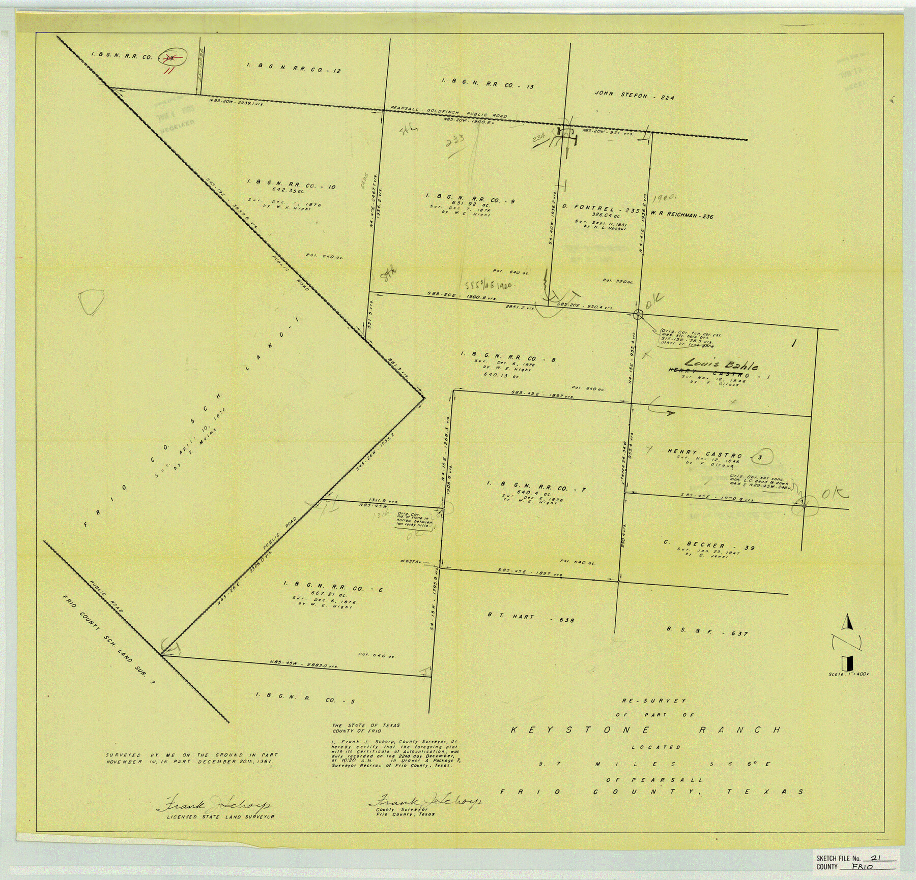
Frio County Sketch File 21
Re-Survey of Part of Keystone Ranch
-
Map/Doc
11520
-
Collection
General Map Collection
-
Object Dates
1938 (Creation Date)
1975/12/11 (File Date)
1961 (Survey Date)
1961/12/20 (Survey Date)
-
People and Organizations
Frank J. Schorp (Surveyor/Engineer)
-
Counties
Frio
-
Subjects
Surveying Sketch File
-
Height x Width
23.4 x 24.3 inches
59.4 x 61.7 cm
-
Medium
blueprint/diazo
-
Scale
1:400
-
Features
Public Road
Part of: General Map Collection
DeWitt County Working Sketch 9

Print $20.00
- Digital $50.00
DeWitt County Working Sketch 9
1979
Size 15.7 x 23.4 inches
Map/Doc 68599
Stephens County Working Sketch 6

Print $20.00
- Digital $50.00
Stephens County Working Sketch 6
1919
Size 13.1 x 22.0 inches
Map/Doc 63949
Carson County Boundary File 9

Print $74.00
- Digital $50.00
Carson County Boundary File 9
Size 9.0 x 8.9 inches
Map/Doc 51175
Glasscock County Sketch File 22

Print $20.00
- Digital $50.00
Glasscock County Sketch File 22
Size 13.8 x 18.6 inches
Map/Doc 11565
Dimmit County Working Sketch 53

Print $20.00
- Digital $50.00
Dimmit County Working Sketch 53
1990
Size 25.5 x 26.0 inches
Map/Doc 68714

Cass County Sketch File 16

Print $4.00
- Digital $50.00
Cass County Sketch File 16
Size 8.5 x 12.8 inches
Map/Doc 17416
Coke County Sketch File 23

Print $20.00
- Digital $50.00
Coke County Sketch File 23
Size 43.9 x 18.5 inches
Map/Doc 10338
Hutchinson County Rolled Sketch 37A

Print $40.00
- Digital $50.00
Hutchinson County Rolled Sketch 37A
1950
Size 26.0 x 51.1 inches
Map/Doc 9247
Hutchinson County Sketch File 44

Print $82.00
- Digital $50.00
Hutchinson County Sketch File 44
1989
Size 11.2 x 9.0 inches
Map/Doc 27311
Loving County Sketch File 9

Print $36.00
- Digital $50.00
Loving County Sketch File 9
2015
Size 14.0 x 8.5 inches
Map/Doc 93794
Scurry County

Print $20.00
- Digital $50.00
Scurry County
1921
Size 42.4 x 39.1 inches
Map/Doc 95637
You may also like
America's Fun-Tier: Texas 1967 Official State Highway Map

Digital $50.00
America's Fun-Tier: Texas 1967 Official State Highway Map
Size 28.3 x 36.6 inches
Map/Doc 94322
Floyd County, Texas

Print $20.00
- Digital $50.00
Floyd County, Texas
1889
Size 24.8 x 19.2 inches
Map/Doc 626
Kimble County Sketch File 26

Print $4.00
- Digital $50.00
Kimble County Sketch File 26
1912
Size 7.8 x 13.0 inches
Map/Doc 28969
Cameron County

Print $20.00
- Digital $50.00
Cameron County
1976
Size 30.9 x 38.1 inches
Map/Doc 77230
Isham Tubbs Estate

Print $3.00
- Digital $50.00
Isham Tubbs Estate
1947
Size 15.5 x 9.3 inches
Map/Doc 92304
Cameron County Sketch File 14

Print $38.00
- Digital $50.00
Cameron County Sketch File 14
1993
Size 11.2 x 8.8 inches
Map/Doc 17311
Flight Mission No. DQO-2K, Frame 83, Galveston County

Print $20.00
- Digital $50.00
Flight Mission No. DQO-2K, Frame 83, Galveston County
1952
Size 18.8 x 22.5 inches
Map/Doc 85010
Andrews County Rolled Sketch 10

Print $40.00
- Digital $50.00
Andrews County Rolled Sketch 10
1931
Size 27.2 x 56.1 inches
Map/Doc 8389
Map of Bosque County

Print $20.00
- Digital $50.00
Map of Bosque County
1869
Size 24.1 x 23.7 inches
Map/Doc 3313
Aransas County NRC Article 33.136 Location Key Sheet

Print $20.00
- Digital $50.00
Aransas County NRC Article 33.136 Location Key Sheet
1979
Size 27.0 x 23.0 inches
Map/Doc 77006
Dickens County Sketch File D2

Print $44.00
- Digital $50.00
Dickens County Sketch File D2
Size 27.2 x 19.1 inches
Map/Doc 20839
Crane County Rolled Sketch 13

Print $20.00
- Digital $50.00
Crane County Rolled Sketch 13
1940
Size 42.4 x 23.3 inches
Map/Doc 5575