Wilbarger County Sketch File 7
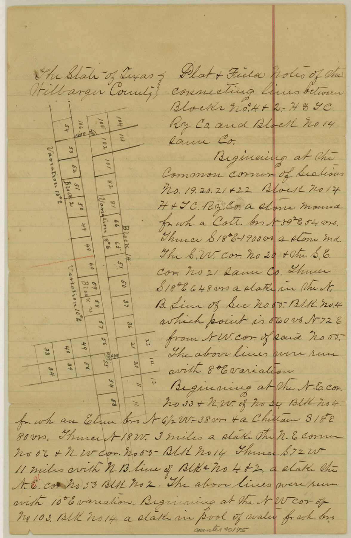
[Plat and field notes of the connecting lines between Blocks 2, 4, and 14, H. & T. C. R.R. Co.]
-
Map/Doc
40175
-
Collection
General Map Collection
-
Object Dates
5/1883 (Creation Date)
8/4/1883 (File Date)
-
People and Organizations
James Warren (Chainman/Field Personnel)
F.W. Jenkins (Chainman/Field Personnel)
W.J. Westmoreland (Surveyor/Engineer)
-
Counties
Wilbarger
-
Subjects
Surveying Sketch File
-
Height x Width
12.7 x 8.3 inches
32.3 x 21.1 cm
-
Medium
paper, manuscript
Part of: General Map Collection
Matagorda Bay and Approaches

Print $20.00
- Digital $50.00
Matagorda Bay and Approaches
1982
Size 36.2 x 44.9 inches
Map/Doc 73388
Flight Mission No. BRA-16M, Frame 176, Jefferson County

Print $20.00
- Digital $50.00
Flight Mission No. BRA-16M, Frame 176, Jefferson County
1953
Size 18.7 x 22.3 inches
Map/Doc 85774
Flight Mission No. DCL-7C, Frame 28, Kenedy County

Print $20.00
- Digital $50.00
Flight Mission No. DCL-7C, Frame 28, Kenedy County
1943
Size 15.4 x 15.4 inches
Map/Doc 86020
Monterey Harbor, California

Print $20.00
- Digital $50.00
Monterey Harbor, California
1852
Size 15.7 x 13.8 inches
Map/Doc 97230
Menard County Sketch File 1

Print $4.00
- Digital $50.00
Menard County Sketch File 1
1859
Size 9.8 x 8.5 inches
Map/Doc 31484
Menard County Rolled Sketch 2A

Print $20.00
- Digital $50.00
Menard County Rolled Sketch 2A
1905
Size 23.3 x 18.5 inches
Map/Doc 6753
Flight Mission No. DIX-10P, Frame 78, Aransas County

Print $20.00
- Digital $50.00
Flight Mission No. DIX-10P, Frame 78, Aransas County
1956
Size 18.8 x 22.4 inches
Map/Doc 83939
Freestone County Working Sketch 29

Print $20.00
- Digital $50.00
Freestone County Working Sketch 29
1994
Size 36.0 x 45.5 inches
Map/Doc 69271
San Patricio County Sketch File 18

Print $4.00
San Patricio County Sketch File 18
Size 6.2 x 8.3 inches
Map/Doc 36066
Map of Brazoria County

Print $20.00
- Digital $50.00
Map of Brazoria County
1883
Size 26.8 x 25.6 inches
Map/Doc 861
Jefferson County NRC Article 33.136 Sketch 2

Print $20.00
- Digital $50.00
Jefferson County NRC Article 33.136 Sketch 2
2002
Size 24.3 x 35.9 inches
Map/Doc 77048
Galveston Bay, Texas

Print $20.00
- Digital $50.00
Galveston Bay, Texas
1905
Size 24.8 x 18.5 inches
Map/Doc 65390
You may also like
Scurry County Rolled Sketch 1

Print $40.00
- Digital $50.00
Scurry County Rolled Sketch 1
Size 70.5 x 44.9 inches
Map/Doc 9910
Chambers County NRC Article 33.136 Sketch 4

Print $48.00
- Digital $50.00
Chambers County NRC Article 33.136 Sketch 4
2003
Size 18.2 x 24.3 inches
Map/Doc 78569
Shelby County Sketch File 20

Print $20.00
- Digital $50.00
Shelby County Sketch File 20
1879
Size 18.3 x 34.6 inches
Map/Doc 12319
Flight Mission No. DAG-21K, Frame 92, Matagorda County

Print $20.00
- Digital $50.00
Flight Mission No. DAG-21K, Frame 92, Matagorda County
1952
Size 18.5 x 22.4 inches
Map/Doc 86421
Shelby County Sketch File 21

Print $2.00
- Digital $50.00
Shelby County Sketch File 21
Size 8.9 x 4.0 inches
Map/Doc 36642
Newton County Sketch File 4b

Print $22.00
- Digital $50.00
Newton County Sketch File 4b
Size 7.6 x 12.2 inches
Map/Doc 32364
Terrell County Rolled Sketch W

Print $20.00
- Digital $50.00
Terrell County Rolled Sketch W
Size 15.4 x 14.3 inches
Map/Doc 7979
Jackson County Sketch File 14

Print $40.00
- Digital $50.00
Jackson County Sketch File 14
Size 22.2 x 9.8 inches
Map/Doc 27660
Current Miscellaneous File 62

Print $64.00
- Digital $50.00
Current Miscellaneous File 62
Size 10.1 x 6.9 inches
Map/Doc 74068
Flight Mission No. BQR-7K, Frame 33, Brazoria County

Print $20.00
- Digital $50.00
Flight Mission No. BQR-7K, Frame 33, Brazoria County
1952
Size 18.7 x 22.3 inches
Map/Doc 84031
Reeves County Rolled Sketch 32

Print $634.00
- Digital $50.00
Reeves County Rolled Sketch 32
1960
Size 10.2 x 15.4 inches
Map/Doc 48849
Shelby County Sketch File 27

Print $4.00
- Digital $50.00
Shelby County Sketch File 27
Size 6.5 x 8.0 inches
Map/Doc 36662