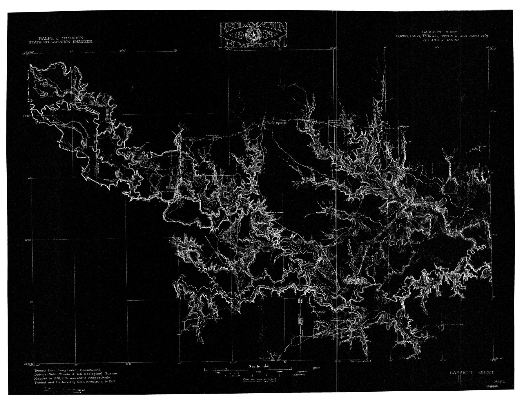
Sulphur River, Bassett Sheet
-
Map/Doc
78322
-
Collection
General Map Collection
-
Object Dates
1939 (Creation Date)
-
People and Organizations
Texas State Reclamation Department (Publisher)
Eltea Armstrong (Draftsman)
Eltea Armstrong (Compiler)
-
Counties
Bowie Cass Morris Titus Red River
-
Subjects
River Surveys Topographic
-
Height x Width
24.8 x 32.0 inches
63.0 x 81.3 cm
-
Comments
Bassett Sheet located next to the Hardison Lake Sheet.
Creeks continued: Dalby, Boothe, Village, Poke, Whiteoak, Caney, Calvert, Eds, Blythe, Ward, Weaver, Bassett, Mill, Elliott, Brooks
Branches: Murphy, Stephenson Ferry, Tuck, Crews
Slough:
Part of: General Map Collection
Map of the Country upon the Brazos and Big Witchita Rivers Explored in 1854 by Capt. R.B. Marcy 5th U.S. Infy. Embracing the Lands appropriated by the State of Texas for the Use of the Indians

Print $20.00
- Digital $50.00
Map of the Country upon the Brazos and Big Witchita Rivers Explored in 1854 by Capt. R.B. Marcy 5th U.S. Infy. Embracing the Lands appropriated by the State of Texas for the Use of the Indians
Size 29.6 x 33.8 inches
Map/Doc 93999
Presidio County Rolled Sketch D

Print $20.00
- Digital $50.00
Presidio County Rolled Sketch D
Size 13.7 x 22.4 inches
Map/Doc 7408
Flight Mission No. BRE-2P, Frame 24, Nueces County

Print $20.00
- Digital $50.00
Flight Mission No. BRE-2P, Frame 24, Nueces County
1956
Size 17.8 x 21.0 inches
Map/Doc 86733
Cottle County Working Sketch 18

Print $20.00
- Digital $50.00
Cottle County Working Sketch 18
1977
Size 32.2 x 41.3 inches
Map/Doc 68328
Pecos County Working Sketch 58

Print $20.00
- Digital $50.00
Pecos County Working Sketch 58
1949
Size 20.5 x 22.0 inches
Map/Doc 71530
Flight Mission No. DAG-23K, Frame 15, Matagorda County

Print $20.00
- Digital $50.00
Flight Mission No. DAG-23K, Frame 15, Matagorda County
1953
Size 15.5 x 15.3 inches
Map/Doc 86477
Panola County Working Sketch 5

Print $20.00
- Digital $50.00
Panola County Working Sketch 5
1940
Map/Doc 71414
Cottle County Sketch File 14

Print $50.00
- Digital $50.00
Cottle County Sketch File 14
1918
Size 11.3 x 8.8 inches
Map/Doc 19491
Map and Profile No. 1 from the Red River to the Rio Grande; from Explorations and surveys made under the direction of the Hon. Jeffeson Davis, Secretary of War

Print $40.00
- Digital $50.00
Map and Profile No. 1 from the Red River to the Rio Grande; from Explorations and surveys made under the direction of the Hon. Jeffeson Davis, Secretary of War
1856
Size 30.5 x 57.0 inches
Map/Doc 4330
Collin County Boundary File 18f

Print $22.00
- Digital $50.00
Collin County Boundary File 18f
Size 12.9 x 8.2 inches
Map/Doc 51757
Railroad Track Map, H&TCRRCo., Falls County, Texas

Print $4.00
- Digital $50.00
Railroad Track Map, H&TCRRCo., Falls County, Texas
1918
Size 11.4 x 18.7 inches
Map/Doc 62851
Glasscock County Rolled Sketch 10

Print $20.00
- Digital $50.00
Glasscock County Rolled Sketch 10
Size 47.6 x 45.9 inches
Map/Doc 9058
You may also like

Flight Mission No. DQN-1K, Frame 31, Calhoun County

Print $20.00
- Digital $50.00
Flight Mission No. DQN-1K, Frame 31, Calhoun County
1953
Size 15.4 x 15.5 inches
Map/Doc 84136
Kerr County Rolled Sketch 25

Print $20.00
- Digital $50.00
Kerr County Rolled Sketch 25
Size 24.7 x 31.0 inches
Map/Doc 6505
Lamb County Rolled Sketch 10

Print $40.00
- Digital $50.00
Lamb County Rolled Sketch 10
1912
Size 31.7 x 70.6 inches
Map/Doc 9418
Section M, Tech Memorial Park, Inc.

Print $3.00
- Digital $50.00
Section M, Tech Memorial Park, Inc.
1950
Size 11.2 x 17.3 inches
Map/Doc 92784
Val Verde County

Print $20.00
- Digital $50.00
Val Verde County
1944
Size 40.8 x 37.7 inches
Map/Doc 78448
Calhoun County Boundary File 3

Print $8.00
- Digital $50.00
Calhoun County Boundary File 3
Size 11.3 x 8.7 inches
Map/Doc 50975
Reeves County Working Sketch 48

Print $20.00
- Digital $50.00
Reeves County Working Sketch 48
1974
Size 41.5 x 31.1 inches
Map/Doc 63491
Flight Mission No. DQO-7K, Frame 85, Galveston County

Print $20.00
- Digital $50.00
Flight Mission No. DQO-7K, Frame 85, Galveston County
1952
Size 18.9 x 22.5 inches
Map/Doc 85112
Robertson County Sketch File 4

Print $12.00
Robertson County Sketch File 4
1862
Size 11.0 x 8.0 inches
Map/Doc 35352
Cameron County Sketch File 17

Print $24.00
- Digital $50.00
Cameron County Sketch File 17
2009
Size 11.0 x 8.5 inches
Map/Doc 95191
Bosque County Boundary File 1

Print $34.00
- Digital $50.00
Bosque County Boundary File 1
Size 10.7 x 8.2 inches
Map/Doc 50672