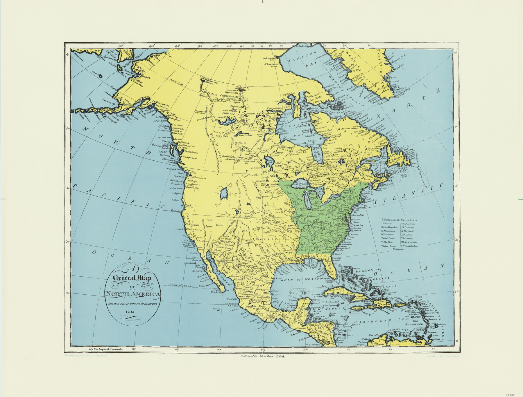
A General Map of North America drawn from the best surveys
-
Map/Doc
93944
-
Collection
General Map Collection
-
Object Dates
1795 (Creation Date)
2015/9/16 (File Date)
1973 (Copy/Tracing Date)
-
People and Organizations
John Reid (Publisher)
-
Subjects
North America
-
Comments
Facsimile published by Tejas Press in 1973 featuring added color.
Part of: General Map Collection
Kaufman County Sketch File 9

Print $8.00
- Digital $50.00
Kaufman County Sketch File 9
1851
Size 9.7 x 7.9 inches
Map/Doc 28640
Crockett County Working Sketch 70

Print $40.00
- Digital $50.00
Crockett County Working Sketch 70
1963
Size 23.7 x 49.5 inches
Map/Doc 68403
Andrews County Sketch File 1

Print $6.00
- Digital $50.00
Andrews County Sketch File 1
Size 9.0 x 13.6 inches
Map/Doc 12818
Donley County Boundary File 1

Print $12.00
- Digital $50.00
Donley County Boundary File 1
Size 11.1 x 8.6 inches
Map/Doc 52613
Castro County Sketch File 4e

Print $4.00
- Digital $50.00
Castro County Sketch File 4e
Size 13.6 x 8.9 inches
Map/Doc 17473
Reagan County Sketch File 12

Print $20.00
- Digital $50.00
Reagan County Sketch File 12
1928
Size 23.2 x 18.3 inches
Map/Doc 12218
Shackelford County Sketch File 12

Print $26.00
- Digital $50.00
Shackelford County Sketch File 12
1949
Size 14.4 x 8.8 inches
Map/Doc 36580
Grayson County Working Sketch 22

Print $20.00
- Digital $50.00
Grayson County Working Sketch 22
1962
Size 21.5 x 33.6 inches
Map/Doc 63261
Brewster County Rolled Sketch 108

Print $20.00
- Digital $50.00
Brewster County Rolled Sketch 108
1958
Size 29.8 x 17.1 inches
Map/Doc 5260
Coke County Rolled Sketch 20

Print $20.00
- Digital $50.00
Coke County Rolled Sketch 20
1954
Size 16.0 x 30.5 inches
Map/Doc 5521
Matagorda County Boundary File 101

Print $10.00
- Digital $50.00
Matagorda County Boundary File 101
Size 8.9 x 7.4 inches
Map/Doc 56896
Map of McCulloch County

Print $20.00
- Digital $50.00
Map of McCulloch County
1858
Size 26.6 x 22.4 inches
Map/Doc 3855
You may also like
Winkler County Working Sketch 1

Print $20.00
- Digital $50.00
Winkler County Working Sketch 1
1944
Size 17.5 x 38.9 inches
Map/Doc 72595

Wichita County

Print $20.00
- Digital $50.00
Wichita County
1881
Size 18.5 x 19.8 inches
Map/Doc 4143
Skeleton Map of Nueces County

Print $20.00
- Digital $50.00
Skeleton Map of Nueces County
Size 35.5 x 39.4 inches
Map/Doc 592
Map of Houston Co.

Print $40.00
- Digital $50.00
Map of Houston Co.
1896
Size 48.8 x 46.8 inches
Map/Doc 76035
Revised Sectional Map No. 4 Showing Land Surveys in the Western Portion of the County of El Paso, Texas

Print $20.00
- Digital $50.00
Revised Sectional Map No. 4 Showing Land Surveys in the Western Portion of the County of El Paso, Texas
Size 24.7 x 19.7 inches
Map/Doc 93226
Flight Mission No. BQY-4M, Frame 60, Harris County

Print $20.00
- Digital $50.00
Flight Mission No. BQY-4M, Frame 60, Harris County
1953
Size 18.6 x 22.3 inches
Map/Doc 85269
El Paso County Working Sketch 8

Print $20.00
- Digital $50.00
El Paso County Working Sketch 8
1952
Size 23.9 x 22.5 inches
Map/Doc 69030
Real County Working Sketch 90

Print $20.00
- Digital $50.00
Real County Working Sketch 90
1991
Size 16.7 x 22.8 inches
Map/Doc 71982
Flight Mission No. DQO-6K, Frame 33, Galveston County

Print $20.00
- Digital $50.00
Flight Mission No. DQO-6K, Frame 33, Galveston County
1952
Size 18.8 x 22.4 inches
Map/Doc 85099
Atascosa County Rolled Sketch 23

Print $20.00
- Digital $50.00
Atascosa County Rolled Sketch 23
1940
Size 36.4 x 24.3 inches
Map/Doc 5102
Motley County Sketch File 21 (N)

Print $4.00
- Digital $50.00
Motley County Sketch File 21 (N)
1943
Size 18.8 x 25.3 inches
Map/Doc 42146