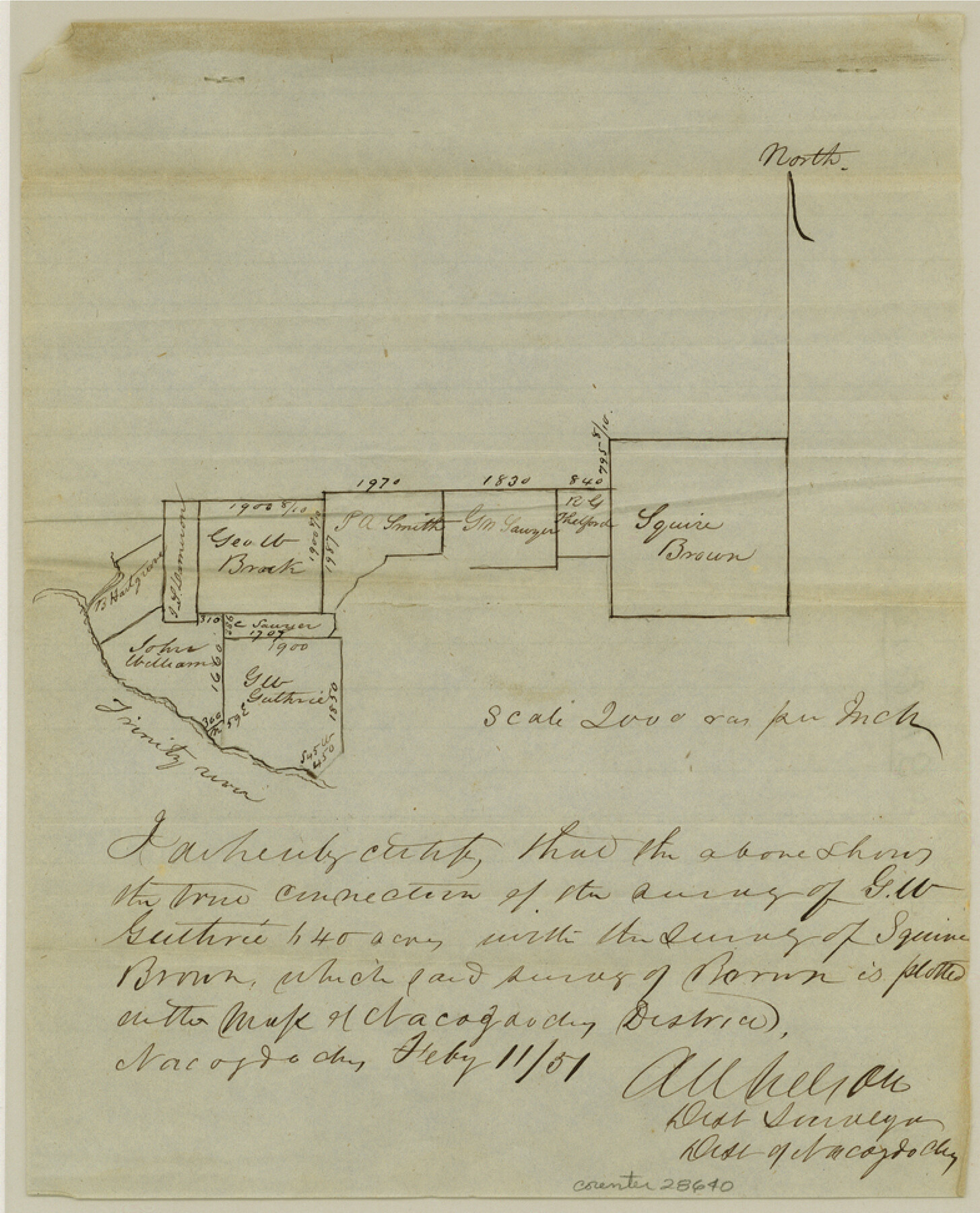
Kaufman County Sketch File 9
[Sketch in southwest corner of the county along east side of Trinity River]
-
Map/Doc
28640
-
Collection
General Map Collection
-
Object Dates
2/11/1851 (Creation Date)
-
People and Organizations
A.A. Nelson (Surveyor/Engineer)
-
Counties
Kaufman
-
Subjects
Surveying Sketch File
-
Height x Width
9.7 x 7.9 inches
24.6 x 20.1 cm
-
Medium
paper, manuscript
-
Scale
1" = 2000 varas
-
Features
Trinity River
Part of: General Map Collection
Maverick County Sketch File 22

Print $32.00
- Digital $50.00
Maverick County Sketch File 22
1892
Size 5.5 x 6.3 inches
Map/Doc 31136
Blanco County Rolled Sketch 20

Print $36.00
- Digital $50.00
Blanco County Rolled Sketch 20
Size 30.7 x 17.0 inches
Map/Doc 87343
Flight Mission No. DQO-2K, Frame 135, Galveston County

Print $20.00
- Digital $50.00
Flight Mission No. DQO-2K, Frame 135, Galveston County
1952
Size 18.7 x 22.5 inches
Map/Doc 85032
Lake Austin, Travis County, Texas

Print $20.00
- Digital $50.00
Lake Austin, Travis County, Texas
1937
Size 24.8 x 16.4 inches
Map/Doc 2056
Brewster County Rolled Sketch 52

Print $40.00
- Digital $50.00
Brewster County Rolled Sketch 52
1935
Size 24.5 x 59.4 inches
Map/Doc 8479
Flight Mission No. CRC-2R, Frame 119, Chambers County

Print $20.00
- Digital $50.00
Flight Mission No. CRC-2R, Frame 119, Chambers County
1956
Size 18.6 x 22.4 inches
Map/Doc 84743
Calhoun County Working Sketch 11

Print $20.00
- Digital $50.00
Calhoun County Working Sketch 11
1952
Size 43.1 x 34.9 inches
Map/Doc 67827
Jim Wells County Rolled Sketch 1

Print $20.00
- Digital $50.00
Jim Wells County Rolled Sketch 1
1981
Size 43.2 x 32.4 inches
Map/Doc 9324
Sterling County Sketch File 3

Print $20.00
- Digital $50.00
Sterling County Sketch File 3
Size 14.5 x 34.8 inches
Map/Doc 12355
La Salle County Working Sketch 26

Print $4.00
- Digital $50.00
La Salle County Working Sketch 26
1949
Size 28.2 x 16.3 inches
Map/Doc 70327
Capitol Complex, Austin, Texas

Print $20.00
- Digital $50.00
Capitol Complex, Austin, Texas
1974
Size 42.7 x 30.6 inches
Map/Doc 94241
Childress County Sketch File 11

Print $6.00
- Digital $50.00
Childress County Sketch File 11
Size 14.0 x 8.6 inches
Map/Doc 18253
You may also like
Limestone County Sketch File B

Print $8.00
- Digital $50.00
Limestone County Sketch File B
1878
Size 8.2 x 7.3 inches
Map/Doc 30151

Central Plains 'Holiness' College Grounds

Print $20.00
- Digital $50.00
Central Plains 'Holiness' College Grounds
1906
Size 17.2 x 30.8 inches
Map/Doc 92124
Houston County Sketch File 1a

Print $4.00
- Digital $50.00
Houston County Sketch File 1a
Size 9.2 x 7.8 inches
Map/Doc 26742
Dickens County

Print $20.00
- Digital $50.00
Dickens County
1884
Size 20.9 x 19.3 inches
Map/Doc 3487
Minnesota Route the shortest and best to the Idaho Gold Mines

Print $20.00
- Digital $50.00
Minnesota Route the shortest and best to the Idaho Gold Mines
Size 21.0 x 46.3 inches
Map/Doc 93989
Hale County Rolled Sketch 6

Print $20.00
- Digital $50.00
Hale County Rolled Sketch 6
1903
Size 35.0 x 28.9 inches
Map/Doc 6045
Duval County Sketch File 8a

Print $4.00
- Digital $50.00
Duval County Sketch File 8a
1875
Size 10.9 x 8.8 inches
Map/Doc 21298
Engineer's Office, Department of the Gulf Map No. 59, Texas prepared by order of Maj. Gen. N. P. Banks under direction of Capt. P. C. Hains, U. S. Engr. & Chief Engr., Dept. of the Gulf

Print $20.00
- Digital $50.00
Engineer's Office, Department of the Gulf Map No. 59, Texas prepared by order of Maj. Gen. N. P. Banks under direction of Capt. P. C. Hains, U. S. Engr. & Chief Engr., Dept. of the Gulf
1865
Size 18.3 x 27.6 inches
Map/Doc 72717
Cooke County Working Sketch 10

Print $20.00
- Digital $50.00
Cooke County Working Sketch 10
1940
Size 40.5 x 27.8 inches
Map/Doc 68247
[Sections 15, 16, 17, 18, Block B]
![92798, [Sections 15, 16, 17, 18, Block B], Twichell Survey Records](https://historictexasmaps.com/wmedia_w700/maps/92798-1.tif.jpg)
Print $20.00
- Digital $50.00
[Sections 15, 16, 17, 18, Block B]
Size 40.0 x 10.5 inches
Map/Doc 92798
[Map of Polk County]
![4613, [Map of Polk County], General Map Collection](https://historictexasmaps.com/wmedia_w700/maps/4613-1.tif.jpg)
Print $20.00
- Digital $50.00
[Map of Polk County]
1855
Size 21.2 x 31.0 inches
Map/Doc 4613