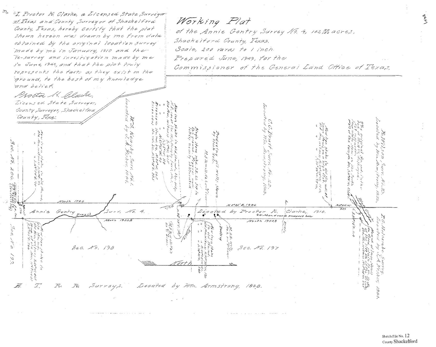
Shackelford County Sketch File 12
[Sketch and surveyor's report regarding a re-survey of the Annie Gentry survey no. 4 in the western part of the county]
-
Map/Doc
36580
-
Collection
General Map Collection
-
Object Dates
6/11/1949 (Creation Date)
6/15/1949 (File Date)
-
People and Organizations
Proctor K. Clarke (Surveyor/Engineer)
-
Counties
Shackelford
-
Subjects
Surveying Sketch File
-
Height x Width
14.4 x 8.8 inches
36.6 x 22.4 cm
-
Medium
multi-page, multi-format
-
Scale
1" = 200 varas
-
Features
Bluff Creek
Part of: General Map Collection
Newton County Sketch File 45

Print $12.00
- Digital $50.00
Newton County Sketch File 45
1957
Size 14.1 x 8.7 inches
Map/Doc 32445
Bee County Boundary File 5

Print $12.00
- Digital $50.00
Bee County Boundary File 5
Size 9.1 x 9.0 inches
Map/Doc 50452
Map of Haskell County

Print $20.00
- Digital $50.00
Map of Haskell County
1899
Size 40.1 x 35.3 inches
Map/Doc 16847
[Right of Way & Track Map, The Texas & Pacific Ry. Co. Main Line]
![64680, [Right of Way & Track Map, The Texas & Pacific Ry. Co. Main Line], General Map Collection](https://historictexasmaps.com/wmedia_w700/maps/64680.tif.jpg)
Print $20.00
- Digital $50.00
[Right of Way & Track Map, The Texas & Pacific Ry. Co. Main Line]
Size 11.0 x 19.0 inches
Map/Doc 64680
Liberty County Working Sketch 46

Print $20.00
- Digital $50.00
Liberty County Working Sketch 46
1953
Size 18.6 x 37.6 inches
Map/Doc 70505
Irion County Boundary File 4

Print $23.00
- Digital $50.00
Irion County Boundary File 4
Size 11.2 x 8.8 inches
Map/Doc 55350
Edwards County Working Sketch 91

Print $40.00
- Digital $50.00
Edwards County Working Sketch 91
1966
Size 34.8 x 51.1 inches
Map/Doc 68967
New Oil and Geological Map of Texas showing Oil Fields, Pipe Lines, Refineries, Geological Formations, Etc.

Print $20.00
- Digital $50.00
New Oil and Geological Map of Texas showing Oil Fields, Pipe Lines, Refineries, Geological Formations, Etc.
1920
Size 22.5 x 31.3 inches
Map/Doc 96633
Kimble County Working Sketch 87

Print $4.00
- Digital $50.00
Kimble County Working Sketch 87
1974
Size 24.1 x 30.0 inches
Map/Doc 70155
Jim Wells Co.

Print $20.00
- Digital $50.00
Jim Wells Co.
1913
Size 43.7 x 22.1 inches
Map/Doc 16861
Roberts County Working Sketch 38

Print $20.00
- Digital $50.00
Roberts County Working Sketch 38
1978
Size 26.7 x 22.5 inches
Map/Doc 63564

You may also like
Flight Mission No. DAG-24K, Frame 150, Matagorda County

Print $20.00
- Digital $50.00
Flight Mission No. DAG-24K, Frame 150, Matagorda County
1953
Size 18.5 x 22.2 inches
Map/Doc 86564
Padre Island National Seashore, Texas - Dependent Resurvey

Print $4.00
- Digital $50.00
Padre Island National Seashore, Texas - Dependent Resurvey
2001
Size 17.8 x 24.2 inches
Map/Doc 60544
Kerr County State Real Property Sketch 1

Print $20.00
- Digital $50.00
Kerr County State Real Property Sketch 1
2007
Size 24.9 x 35.1 inches
Map/Doc 88669
Culberson County Working Sketch 80

Print $40.00
- Digital $50.00
Culberson County Working Sketch 80
1978
Size 56.4 x 43.4 inches
Map/Doc 68534
Flight Mission No. BQR-22K, Frame 37, Brazoria County

Print $20.00
- Digital $50.00
Flight Mission No. BQR-22K, Frame 37, Brazoria County
1953
Size 18.8 x 22.4 inches
Map/Doc 84121
Carson County Sketch File 6a

Print $10.00
- Digital $50.00
Carson County Sketch File 6a
1928
Size 14.1 x 8.4 inches
Map/Doc 17374
Harris County Rolled Sketch P3

Print $20.00
- Digital $50.00
Harris County Rolled Sketch P3
1933
Size 13.9 x 20.0 inches
Map/Doc 6142
Haskell County Rolled Sketch 10

Print $20.00
- Digital $50.00
Haskell County Rolled Sketch 10
1981
Size 33.2 x 14.3 inches
Map/Doc 6169
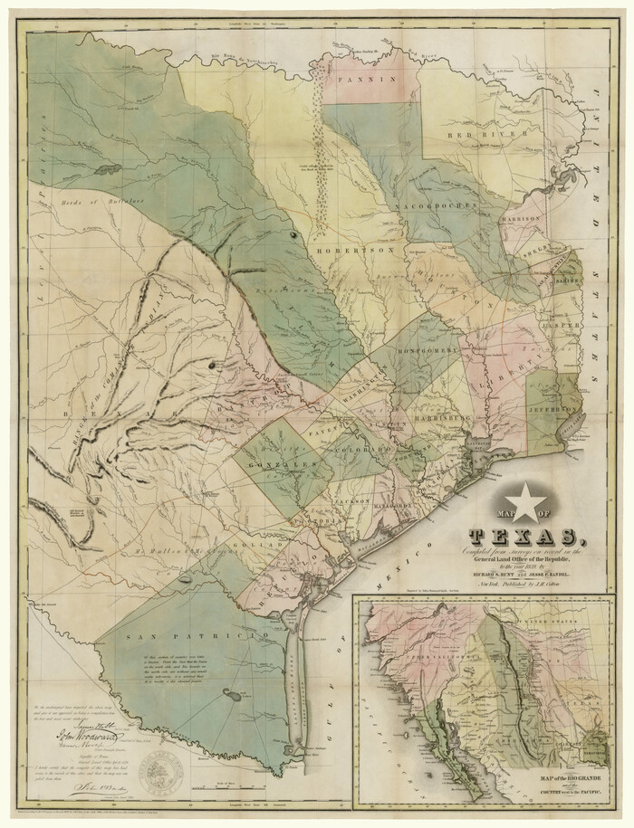
Map of Texas, compiled from surveys on record in the General Land Office of the Republic
Print $20.00
- Digital $50.00
Map of Texas, compiled from surveys on record in the General Land Office of the Republic
1839
Size 33.0 x 25.3 inches
Map/Doc 93858
General Highway Map, Live Oak County, Texas

Print $20.00
General Highway Map, Live Oak County, Texas
1961
Size 18.2 x 24.8 inches
Map/Doc 79574
Dallas County Working Sketch 14

Print $20.00
- Digital $50.00
Dallas County Working Sketch 14
1987
Size 31.2 x 21.7 inches
Map/Doc 68580
Ochiltree County Working Sketch 3

Print $40.00
- Digital $50.00
Ochiltree County Working Sketch 3
1961
Size 111.8 x 37.5 inches
Map/Doc 71316