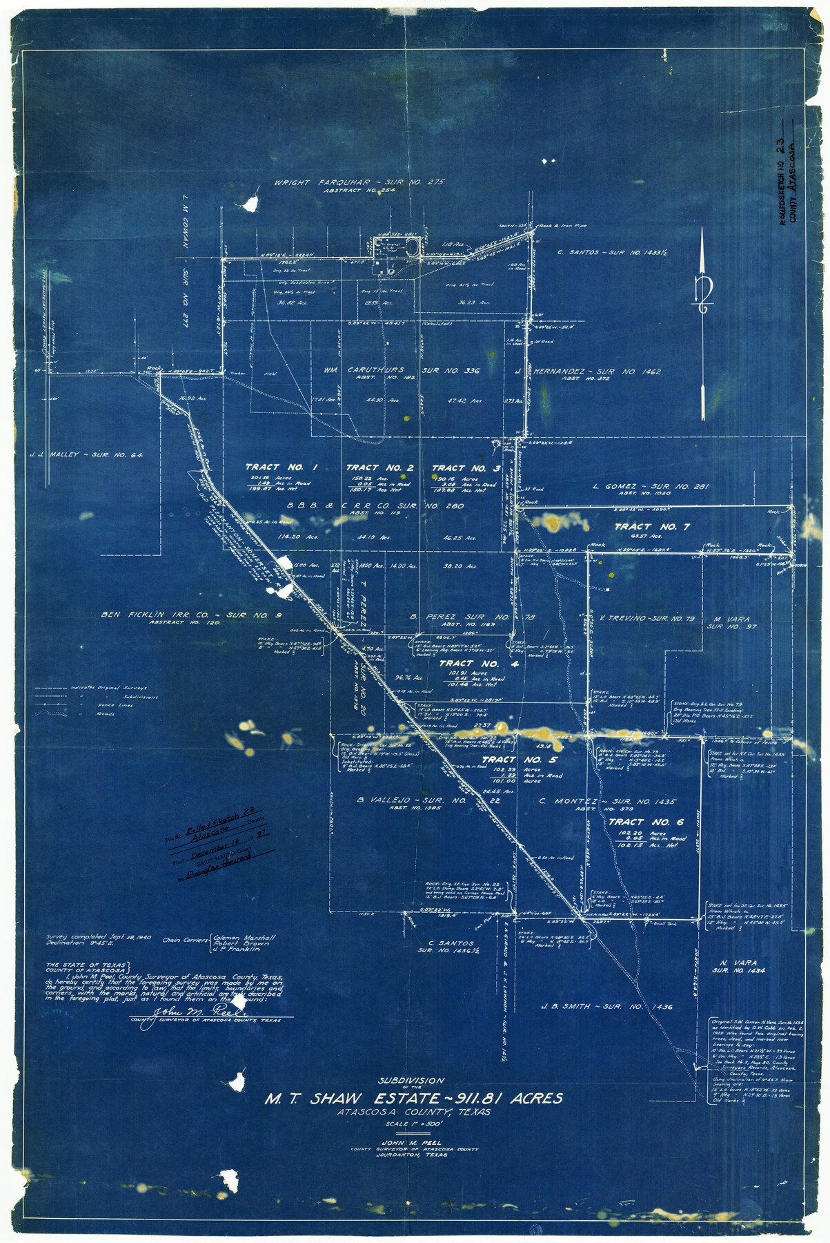
Atascosa County Rolled Sketch 23
Subdivision of the M.T. Shaw estate - 911.81 acres, Atascosa County, Texas
-
Map/Doc
5102
-
Collection
General Map Collection
-
Object Dates
9/28/1940 (Creation Date)
12/16/1997 (File Date)
-
People and Organizations
John M. Peel (Surveyor/Engineer)
-
Counties
Atascosa
-
Subjects
Surveying Rolled Sketch
-
Height x Width
36.4 x 24.3 inches
92.5 x 61.7 cm
-
Medium
blueprint/diazo
-
Scale
1" = 500 feet
-
Comments
See files: Bexar 1st Class 1361, Bexar 3rd Class 3283, 5766, 6451, 6691, 6694, Bexar Bounty 1251, Bexar Scrip 1357, 17969, 44131, Bexar Pre-emption 790, 1065, 1509, 1833, 5930, 6523, 6524, and Scrap File 10903.
Part of: General Map Collection
Brazos Island Harbor, Texas - Dredging Entrance Channel Plan

Print $20.00
- Digital $50.00
Brazos Island Harbor, Texas - Dredging Entrance Channel Plan
1990
Size 14.5 x 19.9 inches
Map/Doc 83339
Jones County Working Sketch 6

Print $20.00
- Digital $50.00
Jones County Working Sketch 6
1951
Size 36.2 x 20.6 inches
Map/Doc 66644
Blanco County Boundary File 4

Print $24.00
- Digital $50.00
Blanco County Boundary File 4
Size 8.9 x 8.3 inches
Map/Doc 50543
Aransas Pass to Baffin Bay

Print $20.00
- Digital $50.00
Aransas Pass to Baffin Bay
1971
Size 42.3 x 35.2 inches
Map/Doc 73417
Nueces County Sketch File 52

Print $10.00
- Digital $50.00
Nueces County Sketch File 52
1947
Size 14.1 x 8.6 inches
Map/Doc 32858
Crockett County Sketch File 95

Print $24.00
- Digital $50.00
Crockett County Sketch File 95
Size 11.2 x 8.9 inches
Map/Doc 19952
Flight Mission No. DCL-7C, Frame 116, Kenedy County

Print $20.00
- Digital $50.00
Flight Mission No. DCL-7C, Frame 116, Kenedy County
1943
Size 18.6 x 22.4 inches
Map/Doc 86081
Atascosa County Sketch File A

Print $40.00
- Digital $50.00
Atascosa County Sketch File A
Size 16.3 x 15.6 inches
Map/Doc 10869
Flight Mission No. DQN-1K, Frame 108, Calhoun County

Print $20.00
- Digital $50.00
Flight Mission No. DQN-1K, Frame 108, Calhoun County
1953
Size 18.4 x 22.1 inches
Map/Doc 84175
Foard County Sketch File 14

Print $4.00
- Digital $50.00
Foard County Sketch File 14
1885
Size 14.4 x 8.8 inches
Map/Doc 22819
Nacogdoches Co.

Print $40.00
- Digital $50.00
Nacogdoches Co.
1905
Size 50.7 x 42.0 inches
Map/Doc 10787
Shackelford County Working Sketch 10

Print $20.00
- Digital $50.00
Shackelford County Working Sketch 10
1984
Size 28.8 x 26.1 inches
Map/Doc 63850
You may also like
[Sketch for Mineral Application 16700 - Pecos River Bed]
![2810, [Sketch for Mineral Application 16700 - Pecos River Bed], General Map Collection](https://historictexasmaps.com/wmedia_w700/maps/2810.tif.jpg)
Print $20.00
- Digital $50.00
[Sketch for Mineral Application 16700 - Pecos River Bed]
1927
Size 17.0 x 36.1 inches
Map/Doc 2810
Trinity County Working Sketch 20

Print $20.00
- Digital $50.00
Trinity County Working Sketch 20
Size 25.9 x 29.7 inches
Map/Doc 69469
Hutchinson County Working Sketch 48

Print $20.00
- Digital $50.00
Hutchinson County Working Sketch 48
1981
Size 36.7 x 29.5 inches
Map/Doc 66408
Andrews County

Print $40.00
- Digital $50.00
Andrews County
1925
Size 42.6 x 57.1 inches
Map/Doc 66703
Wood County Sketch File 15

Print $5.00
- Digital $50.00
Wood County Sketch File 15
1835
Size 11.0 x 16.3 inches
Map/Doc 40694
Cameron County Rolled Sketch 11A

Print $20.00
- Digital $50.00
Cameron County Rolled Sketch 11A
1934
Size 30.0 x 37.0 inches
Map/Doc 11048
Cameron County Boundary File 2

Print $60.00
- Digital $50.00
Cameron County Boundary File 2
Size 47.8 x 22.1 inches
Map/Doc 51095
Wilson County Working Sketch 2

Print $20.00
- Digital $50.00
Wilson County Working Sketch 2
1950
Size 42.0 x 42.8 inches
Map/Doc 72582
Eastland County Sketch File 14

Print $8.00
- Digital $50.00
Eastland County Sketch File 14
Size 11.5 x 9.2 inches
Map/Doc 21595
Jim Hogg County Boundary File 2

Print $4.00
- Digital $50.00
Jim Hogg County Boundary File 2
Size 10.6 x 8.7 inches
Map/Doc 55527
Jules A. Appler's Map of San Antonio, Texas and Suburbs

Print $20.00
Jules A. Appler's Map of San Antonio, Texas and Suburbs
1900
Size 43.0 x 29.7 inches
Map/Doc 79303
Map of Calhoun County

Print $20.00
- Digital $50.00
Map of Calhoun County
1863
Size 23.0 x 19.5 inches
Map/Doc 887