Andrews County Sketch File 1
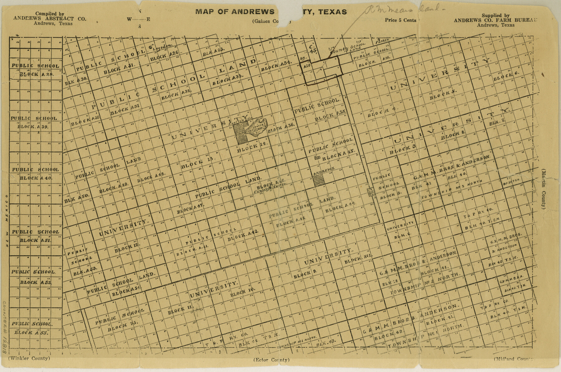
Map of Andrews County, Texas
-
Map/Doc
12818
-
Collection
General Map Collection
-
People and Organizations
Andrews County Farm Bureau (Publisher)
-
Counties
Andrews
-
Subjects
County Surveying Sketch File
-
Height x Width
9.0 x 13.6 inches
22.9 x 34.5 cm
-
Medium
paper, etching/engraving/lithograph
-
Features
Shafter Lake
Andrews
Logsdon
Plorey
Part of: General Map Collection
Laguna Madre, Register No. 1476A

Print $40.00
- Digital $50.00
Laguna Madre, Register No. 1476A
1880
Size 31.3 x 53.3 inches
Map/Doc 73604
Flight Mission No. BQR-13K, Frame 120, Brazoria County

Print $20.00
- Digital $50.00
Flight Mission No. BQR-13K, Frame 120, Brazoria County
1952
Size 18.8 x 22.5 inches
Map/Doc 84081
Stephens County Sketch File 5

Print $6.00
- Digital $50.00
Stephens County Sketch File 5
Size 10.0 x 13.3 inches
Map/Doc 37019
Plan of the town of Austin

Print $20.00
- Digital $50.00
Plan of the town of Austin
Size 18.4 x 13.0 inches
Map/Doc 94117
Duval County Sketch File 70

Print $4.00
- Digital $50.00
Duval County Sketch File 70
1953
Size 14.2 x 9.0 inches
Map/Doc 21456
Harbor Pass and Bar at Brazos Santiago, Texas

Print $20.00
- Digital $50.00
Harbor Pass and Bar at Brazos Santiago, Texas
1879
Size 18.2 x 27.2 inches
Map/Doc 73001
Kinney County Working Sketch 43

Print $20.00
- Digital $50.00
Kinney County Working Sketch 43
1975
Size 42.9 x 33.5 inches
Map/Doc 70225
Montgomery County Sketch File 29

Print $8.00
- Digital $50.00
Montgomery County Sketch File 29
1932
Size 11.2 x 8.6 inches
Map/Doc 31884
Webb County Working Sketch 41

Print $20.00
- Digital $50.00
Webb County Working Sketch 41
1941
Size 15.7 x 18.8 inches
Map/Doc 72406
Travis County Appraisal District Plat Map 2_2313

Print $20.00
- Digital $50.00
Travis County Appraisal District Plat Map 2_2313
Size 21.4 x 26.3 inches
Map/Doc 94215
Brown County Sketch File 10

Print $40.00
- Digital $50.00
Brown County Sketch File 10
1868
Size 17.4 x 22.3 inches
Map/Doc 11019
Austin County Working Sketch 6

Print $20.00
- Digital $50.00
Austin County Working Sketch 6
1985
Size 30.3 x 28.5 inches
Map/Doc 67247
You may also like
Gillespie County Sketch File 3

Print $4.00
- Digital $50.00
Gillespie County Sketch File 3
1847
Size 11.2 x 8.0 inches
Map/Doc 24129
Fisher County Working Sketch 17

Print $20.00
- Digital $50.00
Fisher County Working Sketch 17
1972
Size 32.2 x 24.6 inches
Map/Doc 69151
Brewster County Sketch File NS-7

Print $14.00
- Digital $50.00
Brewster County Sketch File NS-7
1945
Size 11.3 x 8.8 inches
Map/Doc 15992

Jefferson County Sketch File 15a

Print $8.00
- Digital $50.00
Jefferson County Sketch File 15a
1872
Size 15.6 x 6.7 inches
Map/Doc 28156
Edwards County Working Sketch 35

Print $20.00
- Digital $50.00
Edwards County Working Sketch 35
1948
Size 20.9 x 31.1 inches
Map/Doc 68911
Fractional Township No. 10 South Range No. 24 East of the Indian Meridian, Indian Territory

Print $20.00
- Digital $50.00
Fractional Township No. 10 South Range No. 24 East of the Indian Meridian, Indian Territory
1898
Size 19.1 x 24.2 inches
Map/Doc 75242
Midland County Working Sketch 24

Print $40.00
- Digital $50.00
Midland County Working Sketch 24
1957
Size 42.9 x 80.9 inches
Map/Doc 71005
Hale County Sketch File C

Print $20.00
- Digital $50.00
Hale County Sketch File C
1901
Size 20.1 x 24.1 inches
Map/Doc 11600
J No. 4 - Reconnaissance of Catalina Harbor And the Anchorage on the N.E. Side of the Island, California

Print $20.00
- Digital $50.00
J No. 4 - Reconnaissance of Catalina Harbor And the Anchorage on the N.E. Side of the Island, California
1852
Size 18.3 x 13.1 inches
Map/Doc 97231
Anderson County Working Sketch 42

Print $40.00
- Digital $50.00
Anderson County Working Sketch 42
1987
Size 34.4 x 51.1 inches
Map/Doc 67042
Collin County Boundary File 18 and 18a

Print $8.00
- Digital $50.00
Collin County Boundary File 18 and 18a
Size 7.8 x 4.0 inches
Map/Doc 51717