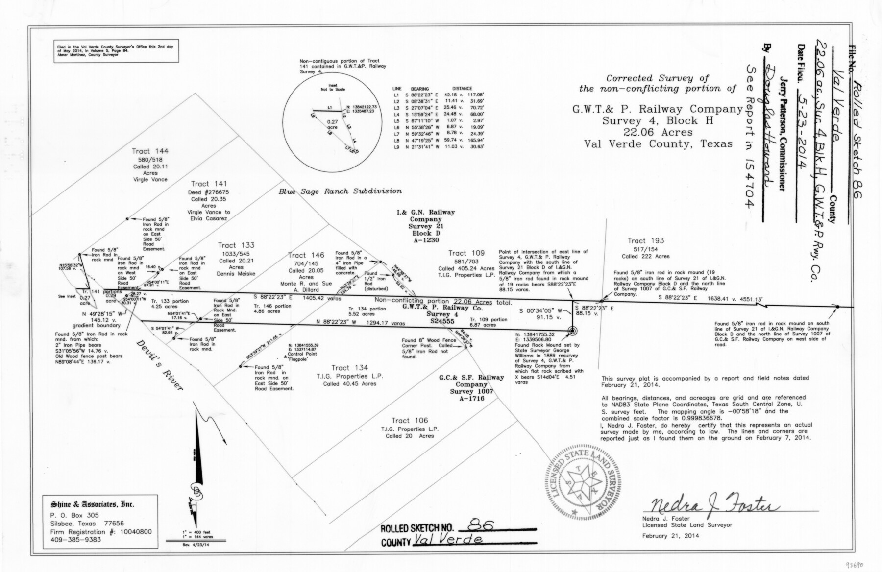
Val Verde County Rolled Sketch 86
Corrected survey of the non-conflicting portion of G. W. T. & P. Railway Company survey 4, Block H, 22.06 acres, Val Verde County, Texas
-
Map/Doc
93690
-
Collection
General Map Collection
-
Object Dates
2014/2/7 (Survey Date)
2014/5/23 (File Date)
2014/4/23 (Revision Date)
2014/2/21 (Creation Date)
-
People and Organizations
Nedra J. Foster (Surveyor/Engineer)
-
Counties
Val Verde
-
Subjects
Surveying Rolled Sketch
-
Height x Width
11.9 x 18.4 inches
30.2 x 46.7 cm
-
Medium
mylar, print
-
Scale
1" = 144 varas
-
Comments
See surveyor's report in School File 154704.
Part of: General Map Collection
[Map of Parker County]
![3941, [Map of Parker County], General Map Collection](https://historictexasmaps.com/wmedia_w700/maps/3941.tif.jpg)
Print $20.00
- Digital $50.00
[Map of Parker County]
Size 22.0 x 34.0 inches
Map/Doc 3941
Midland County Boundary File 4a

Print $40.00
- Digital $50.00
Midland County Boundary File 4a
Size 36.2 x 54.5 inches
Map/Doc 57185
Starr County Sketch File 37

Print $10.00
- Digital $50.00
Starr County Sketch File 37
1940
Size 2.7 x 8.8 inches
Map/Doc 36980
Zavala County Rolled Sketch 16

Print $20.00
- Digital $50.00
Zavala County Rolled Sketch 16
Size 19.4 x 25.4 inches
Map/Doc 8321
Texas-Oklahoma (Indian Territory) Gainesville Quadrangle

Print $20.00
- Digital $50.00
Texas-Oklahoma (Indian Territory) Gainesville Quadrangle
1902
Size 21.2 x 17.2 inches
Map/Doc 75101
Sherman County Rolled Sketch 12

Print $40.00
- Digital $50.00
Sherman County Rolled Sketch 12
1951
Size 11.1 x 63.8 inches
Map/Doc 9929
Newton County Working Sketch 8

Print $20.00
- Digital $50.00
Newton County Working Sketch 8
1937
Size 23.2 x 18.5 inches
Map/Doc 71254
Scarborough's Map of the New England States Vermont, New Hampshire, Maine, Massachusetts, Rhode Island and Connecticut

Print $40.00
- Digital $50.00
Scarborough's Map of the New England States Vermont, New Hampshire, Maine, Massachusetts, Rhode Island and Connecticut
1910
Size 58.3 x 40.1 inches
Map/Doc 97106
Flight Mission No. DCL-5C, Frame 68, Kenedy County

Print $20.00
- Digital $50.00
Flight Mission No. DCL-5C, Frame 68, Kenedy County
1943
Size 18.6 x 22.4 inches
Map/Doc 85851
Gaines County Sketch File 6

Print $20.00
- Digital $50.00
Gaines County Sketch File 6
1924
Size 20.9 x 21.3 inches
Map/Doc 11523
Stephens County Sketch File 15

Print $4.00
- Digital $50.00
Stephens County Sketch File 15
1890
Size 9.1 x 6.7 inches
Map/Doc 37068
Chambers County Rolled Sketch 25

Print $20.00
- Digital $50.00
Chambers County Rolled Sketch 25
1944
Size 33.9 x 31.5 inches
Map/Doc 8618
You may also like
Travis County Appraisal District Plat Map 2_0018

Print $20.00
- Digital $50.00
Travis County Appraisal District Plat Map 2_0018
Size 21.6 x 26.5 inches
Map/Doc 94208
Flight Mission No. CUG-2P, Frame 61, Kleberg County

Print $20.00
- Digital $50.00
Flight Mission No. CUG-2P, Frame 61, Kleberg County
1956
Size 18.5 x 22.2 inches
Map/Doc 86198
Starr County Working Sketch 17

Print $20.00
- Digital $50.00
Starr County Working Sketch 17
1982
Size 46.1 x 42.7 inches
Map/Doc 63933
Pecos County Sketch File 25

Print $20.00
- Digital $50.00
Pecos County Sketch File 25
Size 17.6 x 24.9 inches
Map/Doc 12164
Starr County Rolled Sketch 27

Print $20.00
- Digital $50.00
Starr County Rolled Sketch 27
1940
Size 21.4 x 28.6 inches
Map/Doc 7810
Crosby County School Land, Lamb and Bailey Counties

Print $20.00
- Digital $50.00
Crosby County School Land, Lamb and Bailey Counties
Size 12.4 x 14.9 inches
Map/Doc 90109
Flight Mission No. BRA-8M, Frame 114, Jefferson County

Print $20.00
- Digital $50.00
Flight Mission No. BRA-8M, Frame 114, Jefferson County
1953
Size 18.6 x 22.2 inches
Map/Doc 85610
Jasper County Working Sketch 8

Print $20.00
- Digital $50.00
Jasper County Working Sketch 8
1915
Size 20.1 x 31.4 inches
Map/Doc 66470
Culberson County Sketch File 1b

Print $20.00
- Digital $50.00
Culberson County Sketch File 1b
Size 9.0 x 18.0 inches
Map/Doc 11260
Travels to the source of the Missouri River and across the American Continent to the Pacific Ocean - Vol. 3

Travels to the source of the Missouri River and across the American Continent to the Pacific Ocean - Vol. 3
1815
Map/Doc 97414
Zapata County Rolled Sketch 10A

Print $20.00
- Digital $50.00
Zapata County Rolled Sketch 10A
1912
Size 26.3 x 26.5 inches
Map/Doc 8312
Henderson County Rolled Sketch 11

Print $20.00
- Digital $50.00
Henderson County Rolled Sketch 11
1915
Size 28.9 x 42.6 inches
Map/Doc 76148