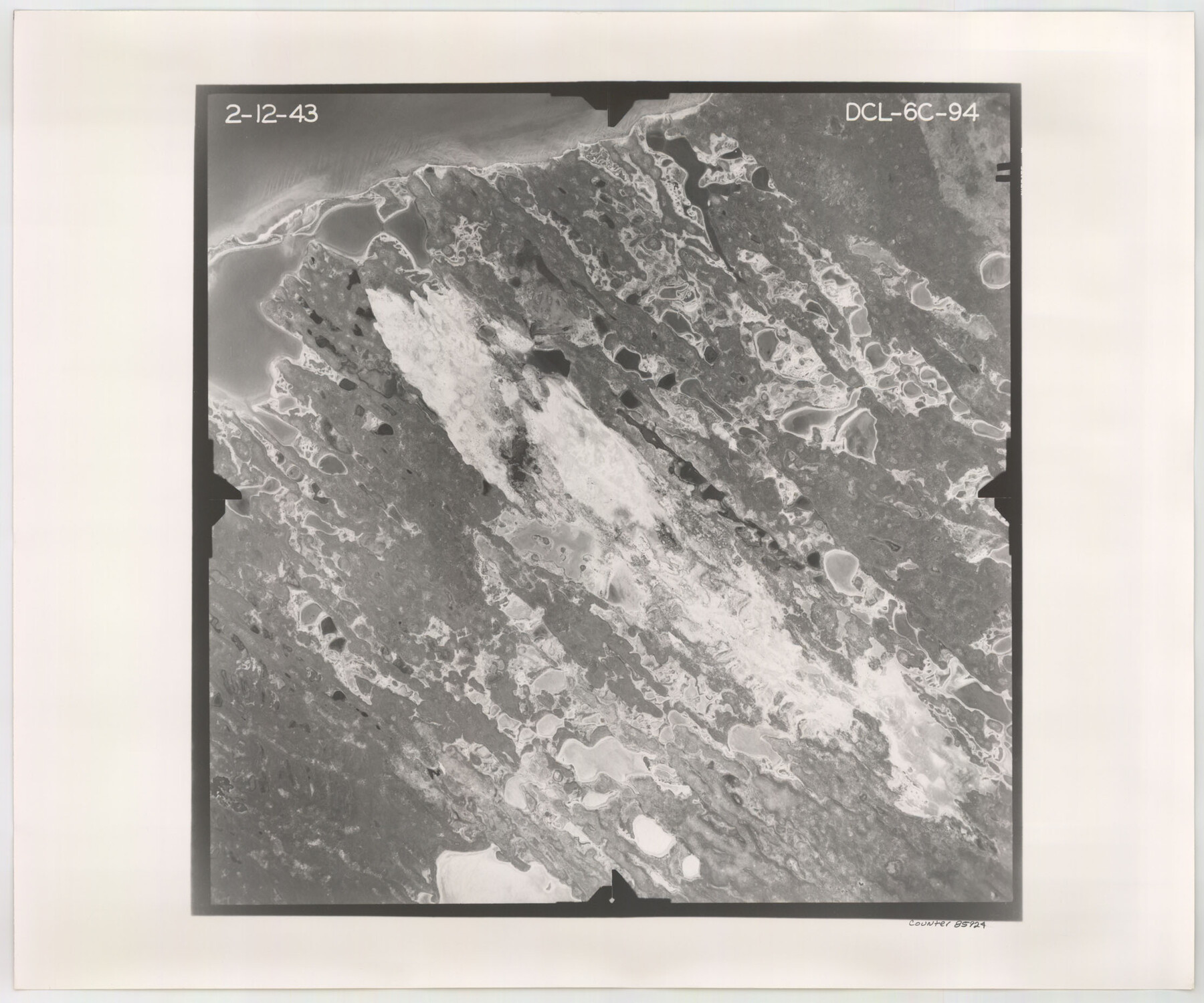
Flight Mission No. DCL-6C, Frame 94, Kenedy County
DCL-6C-94
-
Map/Doc
85924
-
Collection
General Map Collection
-
Object Dates
1943/2/12 (Creation Date)
-
People and Organizations
U. S. Department of Agriculture (Publisher)
-
Counties
Kenedy
-
Subjects
Aerial Photograph
-
Height x Width
18.6 x 22.3 inches
47.2 x 56.6 cm
-
Comments
Flown by Aerial Surveys of Pittsburgh, Inc. of Pittsburgh, Pennsylvania.
Part of: General Map Collection
Tyler County Sketch File 6

Print $6.00
- Digital $50.00
Tyler County Sketch File 6
1848
Size 6.0 x 7.1 inches
Map/Doc 38630
Brooks County Rolled Sketch 25

Print $20.00
- Digital $50.00
Brooks County Rolled Sketch 25
1945
Size 21.6 x 26.4 inches
Map/Doc 5345
Lavaca County Working Sketch 14

Print $20.00
- Digital $50.00
Lavaca County Working Sketch 14
1962
Size 28.4 x 29.7 inches
Map/Doc 70367
Motley County Sketch File B3 (N)

Print $10.00
- Digital $50.00
Motley County Sketch File B3 (N)
1900
Size 6.5 x 11.9 inches
Map/Doc 31974
Flight Mission No. DQO-8K, Frame 132, Galveston County

Print $20.00
- Digital $50.00
Flight Mission No. DQO-8K, Frame 132, Galveston County
1952
Size 18.8 x 22.6 inches
Map/Doc 85197
Red River County Working Sketch 33

Print $20.00
- Digital $50.00
Red River County Working Sketch 33
1963
Size 47.0 x 22.2 inches
Map/Doc 72016
Garza County Sketch File 32

Print $28.00
- Digital $50.00
Garza County Sketch File 32
1932
Size 8.9 x 14.3 inches
Map/Doc 24109
Pecos County Sketch File 1A

Print $20.00
- Digital $50.00
Pecos County Sketch File 1A
1919
Size 34.3 x 23.7 inches
Map/Doc 12155
Surveyor's Watercourse Report 2

Print $42.00
Surveyor's Watercourse Report 2
2025
Size 11.0 x 8.5 inches
Map/Doc 97512
Liberty County Sketch File 11

Print $6.00
- Digital $50.00
Liberty County Sketch File 11
1858
Size 11.8 x 10.0 inches
Map/Doc 29905
[Sketch for Mineral Application 16700 - Pecos River Bed]
![2810, [Sketch for Mineral Application 16700 - Pecos River Bed], General Map Collection](https://historictexasmaps.com/wmedia_w700/maps/2810.tif.jpg)
Print $20.00
- Digital $50.00
[Sketch for Mineral Application 16700 - Pecos River Bed]
1927
Size 17.0 x 36.1 inches
Map/Doc 2810
Donley County Sketch File 21

Print $4.00
- Digital $50.00
Donley County Sketch File 21
Size 8.4 x 9.5 inches
Map/Doc 21256
You may also like
General Highway Map, Jones County, Texas

Print $20.00
General Highway Map, Jones County, Texas
1961
Size 18.2 x 24.5 inches
Map/Doc 79546
Navarro County Sketch File 5

Print $6.00
- Digital $50.00
Navarro County Sketch File 5
1852
Size 5.5 x 8.1 inches
Map/Doc 32307
Flight Mission No. BRA-16M, Frame 90, Jefferson County

Print $20.00
- Digital $50.00
Flight Mission No. BRA-16M, Frame 90, Jefferson County
1953
Size 18.5 x 22.2 inches
Map/Doc 85702
Aransas County Sketch File 8

Print $4.00
- Digital $50.00
Aransas County Sketch File 8
Size 11.7 x 7.9 inches
Map/Doc 13114
Plat of Littlefield, Texas

Print $20.00
- Digital $50.00
Plat of Littlefield, Texas
Size 23.6 x 19.3 inches
Map/Doc 90990
Fort Bend County Working Sketch 15

Print $20.00
- Digital $50.00
Fort Bend County Working Sketch 15
1950
Size 22.5 x 14.7 inches
Map/Doc 69221
Section across Valley Bench and Terraces - South Side of Red River - Big Bend Area

Print $20.00
Section across Valley Bench and Terraces - South Side of Red River - Big Bend Area
1921
Size 10.2 x 34.8 inches
Map/Doc 79750

Map of Bastrop County, Texas

Print $20.00
- Digital $50.00
Map of Bastrop County, Texas
1879
Size 25.2 x 23.3 inches
Map/Doc 693
Cameron County Rolled Sketch 19

Print $20.00
- Digital $50.00
Cameron County Rolled Sketch 19
1937
Size 26.0 x 21.8 inches
Map/Doc 5470
Presidio County Working Sketch 98

Print $20.00
- Digital $50.00
Presidio County Working Sketch 98
1978
Size 30.9 x 31.7 inches
Map/Doc 71775
Mills County Sketch File 23

Print $4.00
- Digital $50.00
Mills County Sketch File 23
Size 12.4 x 9.2 inches
Map/Doc 31672