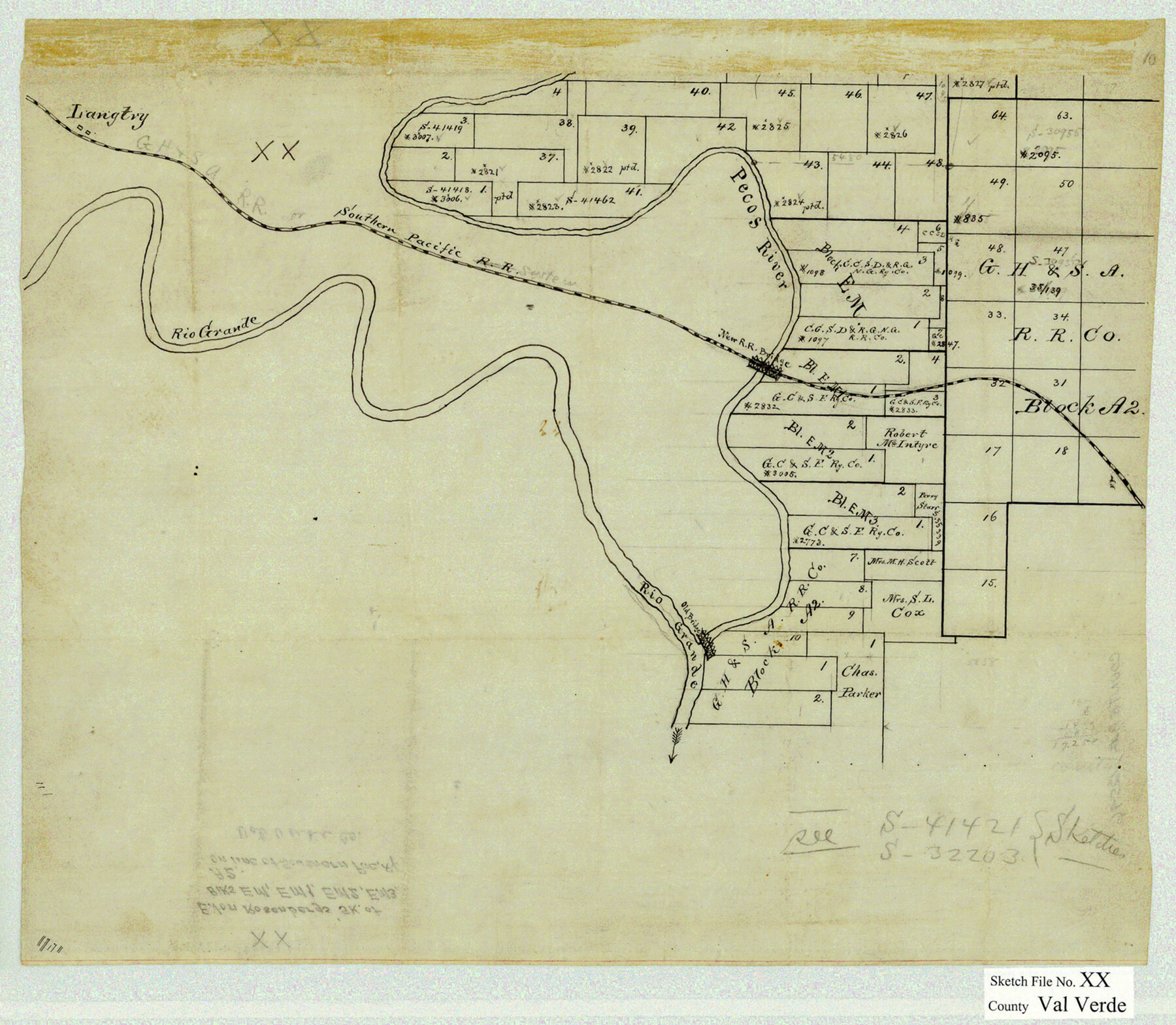
Val Verde County Sketch File XX
[Office sketch of Blocks EM, EM1, EM2, EM3, and A2 on the east side of the Pecos River]
-
Map/Doc
12546
-
Collection
General Map Collection
-
People and Organizations
E. von Rosenberg (Draftsman)
-
Counties
Val Verde
-
Subjects
Surveying Sketch File
-
Height x Width
14.5 x 16.7 inches
36.8 x 42.4 cm
-
Medium
paper, manuscript
-
Features
Langtry
Rio Grande
Pecos River
New Railroad Brudge
Old Bridge
Part of: General Map Collection
Bosque County Sketch File 14

Print $22.00
- Digital $50.00
Bosque County Sketch File 14
1863
Size 12.2 x 7.6 inches
Map/Doc 14763
Bee County Sketch File 24

Print $8.00
- Digital $50.00
Bee County Sketch File 24
1879
Size 10.2 x 8.3 inches
Map/Doc 14322
University Lands Blocks 34 to 37, Terrell County

Print $20.00
- Digital $50.00
University Lands Blocks 34 to 37, Terrell County
1938
Size 32.8 x 40.0 inches
Map/Doc 2451
Shelby County Sketch File 13

Print $2.00
- Digital $50.00
Shelby County Sketch File 13
1859
Size 8.2 x 12.8 inches
Map/Doc 36621
Winkler County Working Sketch 17

Print $20.00
- Digital $50.00
Winkler County Working Sketch 17
1973
Size 36.5 x 36.7 inches
Map/Doc 72611
McLennan County Boundary File 6

Print $16.00
- Digital $50.00
McLennan County Boundary File 6
Size 11.1 x 8.6 inches
Map/Doc 56997
Harris County Sketch File 46

Print $6.00
- Digital $50.00
Harris County Sketch File 46
1906
Size 8.8 x 13.7 inches
Map/Doc 25443
Flight Mission No. DQO-3K, Frame 39, Galveston County

Print $20.00
- Digital $50.00
Flight Mission No. DQO-3K, Frame 39, Galveston County
1952
Size 18.8 x 22.5 inches
Map/Doc 85080
Jim Hogg Co. / Brooks Co.

Print $20.00
- Digital $50.00
Jim Hogg Co. / Brooks Co.
1912
Size 33.0 x 43.6 inches
Map/Doc 4894
Flight Mission No. DAG-23K, Frame 149, Matagorda County

Print $20.00
- Digital $50.00
Flight Mission No. DAG-23K, Frame 149, Matagorda County
1953
Size 15.9 x 15.9 inches
Map/Doc 86497
Van Zandt County Sketch File 40

Print $4.00
- Digital $50.00
Van Zandt County Sketch File 40
Size 8.6 x 9.4 inches
Map/Doc 39486
Galveston County Sketch File 24

Print $20.00
- Digital $50.00
Galveston County Sketch File 24
Size 15.8 x 18.1 inches
Map/Doc 11531
You may also like

Flight Mission No. DCL-7C, Frame 107, Kenedy County

Print $20.00
- Digital $50.00
Flight Mission No. DCL-7C, Frame 107, Kenedy County
1943
Size 18.4 x 22.2 inches
Map/Doc 86072
Hall County Boundary File 1c

Print $40.00
- Digital $50.00
Hall County Boundary File 1c
Size 10.0 x 34.6 inches
Map/Doc 54175
United States - Gulf Coast - Padre I. and Laguna Madre Lat. 27° 12' to Lat. 26° 33' Texas

Print $20.00
- Digital $50.00
United States - Gulf Coast - Padre I. and Laguna Madre Lat. 27° 12' to Lat. 26° 33' Texas
1913
Size 26.8 x 18.2 inches
Map/Doc 72815
Montgomery County Working Sketch 39

Print $20.00
- Digital $50.00
Montgomery County Working Sketch 39
1954
Size 24.1 x 46.5 inches
Map/Doc 71146
Map of Texas, compiled from surveys on record in the General Land Office of the Republic

Print $20.00
Map of Texas, compiled from surveys on record in the General Land Office of the Republic
1847
Size 32.2 x 25.0 inches
Map/Doc 79325
[Leagues 701-714 and vicinity]
![90460, [Leagues 701-714 and vicinity], Twichell Survey Records](https://historictexasmaps.com/wmedia_w700/maps/90460-1.tif.jpg)
Print $20.00
- Digital $50.00
[Leagues 701-714 and vicinity]
Size 37.7 x 22.8 inches
Map/Doc 90460
Culberson County Working Sketch 25

Print $40.00
- Digital $50.00
Culberson County Working Sketch 25
1951
Size 36.9 x 52.5 inches
Map/Doc 62343
El Paso County Working Sketch 12

Print $20.00
- Digital $50.00
El Paso County Working Sketch 12
1956
Size 33.0 x 41.4 inches
Map/Doc 69034
Henderson County Boundary File 3

Print $32.00
- Digital $50.00
Henderson County Boundary File 3
Size 6.3 x 14.0 inches
Map/Doc 54669
Parker County Sketch File 45

Print $10.00
- Digital $50.00
Parker County Sketch File 45
1935
Size 11.0 x 8.5 inches
Map/Doc 33610
[Surveys along the Trinity River]
![297, [Surveys along the Trinity River], General Map Collection](https://historictexasmaps.com/wmedia_w700/maps/297.tif.jpg)
Print $3.00
- Digital $50.00
[Surveys along the Trinity River]
Size 17.8 x 9.5 inches
Map/Doc 297