Brewster County Sketch File N-3b
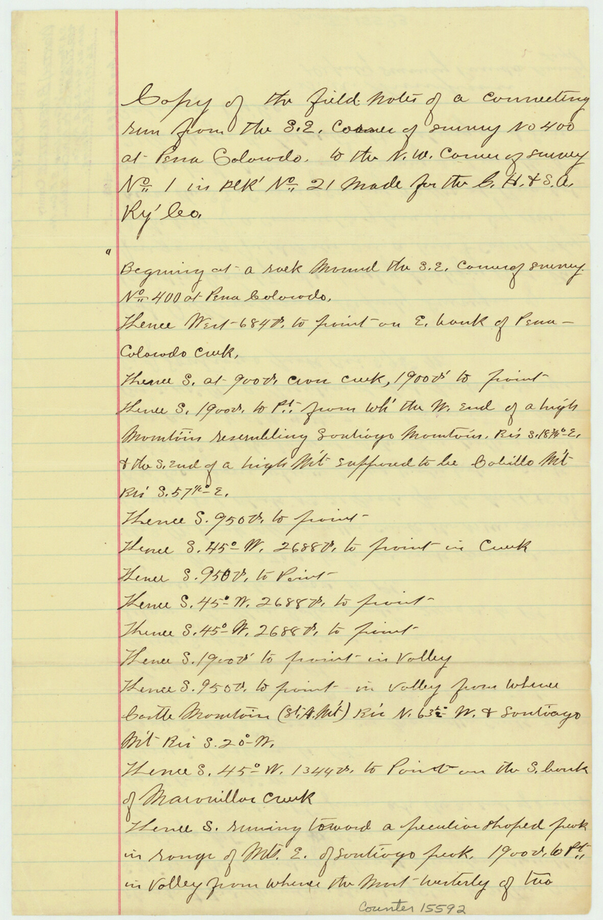
Copy of the field notes of a connecting line run from the SE corner of survey no. 400 at Pena Colorado to the NW corner of survey no. 1 in Block 21 made for the G. H. & S. A. Ry. Co.
-
Map/Doc
15592
-
Collection
General Map Collection
-
Object Dates
1882/8/18 (File Date)
-
People and Organizations
S.A. Thompson (Surveyor/Engineer)
-
Counties
Brewster
-
Subjects
Surveying Sketch File
-
Height x Width
12.7 x 8.4 inches
32.3 x 21.3 cm
-
Medium
paper, manuscript
-
Features
Pena Colorado Creek
Santiago Mountain
Maravillas Creek
Part of: General Map Collection
Grimes County Rolled Sketch 2

Print $20.00
- Digital $50.00
Grimes County Rolled Sketch 2
Size 29.2 x 24.3 inches
Map/Doc 6043
Hood County Sketch File 6

Print $4.00
- Digital $50.00
Hood County Sketch File 6
Size 7.2 x 6.1 inches
Map/Doc 26579

Polk County Sketch File 25a

Print $8.00
- Digital $50.00
Polk County Sketch File 25a
Size 13.3 x 10.0 inches
Map/Doc 34180

Map of Comal County

Print $20.00
- Digital $50.00
Map of Comal County
1862
Size 18.6 x 22.0 inches
Map/Doc 3429

Jackson County Sketch File 1

Print $4.00
- Digital $50.00
Jackson County Sketch File 1
1859
Size 9.9 x 7.6 inches
Map/Doc 27617
Houston County Sketch File 13

Print $6.00
- Digital $50.00
Houston County Sketch File 13
Size 9.0 x 7.8 inches
Map/Doc 26775
Flight Mission No. DAH-17M, Frame 31, Orange County

Print $20.00
- Digital $50.00
Flight Mission No. DAH-17M, Frame 31, Orange County
1953
Size 18.7 x 22.5 inches
Map/Doc 86894
Eastland County Sketch File 1

Print $8.00
- Digital $50.00
Eastland County Sketch File 1
Size 9.0 x 7.9 inches
Map/Doc 21555
Spanish and Mexican Land Grants in Texas

Print $20.00
Spanish and Mexican Land Grants in Texas
2015
Size 34.0 x 44.0 inches
Map/Doc 93755
You may also like
Liberty County Sketch File 18

Print $6.00
- Digital $50.00
Liberty County Sketch File 18
1859
Size 8.0 x 9.2 inches
Map/Doc 29920
Schleicher County Sketch File 27

Print $20.00
- Digital $50.00
Schleicher County Sketch File 27
Size 23.0 x 19.2 inches
Map/Doc 12305
[University Blocks 17 and 18, Block Z, C4, 194, 178, A2, C3]
![93199, [University Blocks 17 and 18, Block Z, C4, 194, 178, A2, C3], Twichell Survey Records](https://historictexasmaps.com/wmedia_w700/maps/93199-1.tif.jpg)
Print $40.00
- Digital $50.00
[University Blocks 17 and 18, Block Z, C4, 194, 178, A2, C3]
1882
Size 81.8 x 54.1 inches
Map/Doc 93199
Martin County

Print $20.00
- Digital $50.00
Martin County
1933
Size 38.9 x 34.0 inches
Map/Doc 77366
Flight Mission No. CRC-5R, Frame 17, Chambers County

Print $20.00
- Digital $50.00
Flight Mission No. CRC-5R, Frame 17, Chambers County
1956
Size 18.8 x 22.5 inches
Map/Doc 84939
General Highway Map. Detail of Cities and Towns in Harris County, Texas. City Map [of] Houston, Pasadena, West University Place, Bellaire, Galena Park, Jacinto City, South Houston, South Side Place, Deer Park, and vicinity, Harris County, Texas
![79507, General Highway Map. Detail of Cities and Towns in Harris County, Texas. City Map [of] Houston, Pasadena, West University Place, Bellaire, Galena Park, Jacinto City, South Houston, South Side Place, Deer Park, and vicinity, Harris County, Texas, Texas State Library and Archives](https://historictexasmaps.com/wmedia_w700/maps/79507.tif.jpg)
Print $20.00
General Highway Map. Detail of Cities and Towns in Harris County, Texas. City Map [of] Houston, Pasadena, West University Place, Bellaire, Galena Park, Jacinto City, South Houston, South Side Place, Deer Park, and vicinity, Harris County, Texas
1961
Size 18.1 x 24.7 inches
Map/Doc 79507
Foard County Working Sketch 13

Print $40.00
- Digital $50.00
Foard County Working Sketch 13
1981
Size 44.0 x 51.2 inches
Map/Doc 69204
Bailey County

Print $20.00
- Digital $50.00
Bailey County
1913
Size 28.8 x 22.3 inches
Map/Doc 66707
Flight Mission No. BRA-7M, Frame 7, Jefferson County

Print $20.00
- Digital $50.00
Flight Mission No. BRA-7M, Frame 7, Jefferson County
1953
Size 18.7 x 22.5 inches
Map/Doc 85458
Dallas County Boundary File 5a

Print $4.00
- Digital $50.00
Dallas County Boundary File 5a
Size 4.9 x 8.6 inches
Map/Doc 52182
Crane County Sketch File 19

Print $4.00
- Digital $50.00
Crane County Sketch File 19
1927
Size 11.4 x 8.8 inches
Map/Doc 19584
[Stone, Kyle and Kyle Block M6]
![90395, [Stone, Kyle and Kyle Block M6], Twichell Survey Records](https://historictexasmaps.com/wmedia_w700/maps/90395-1.tif.jpg)
Print $20.00
- Digital $50.00
[Stone, Kyle and Kyle Block M6]
Size 26.8 x 21.6 inches
Map/Doc 90395