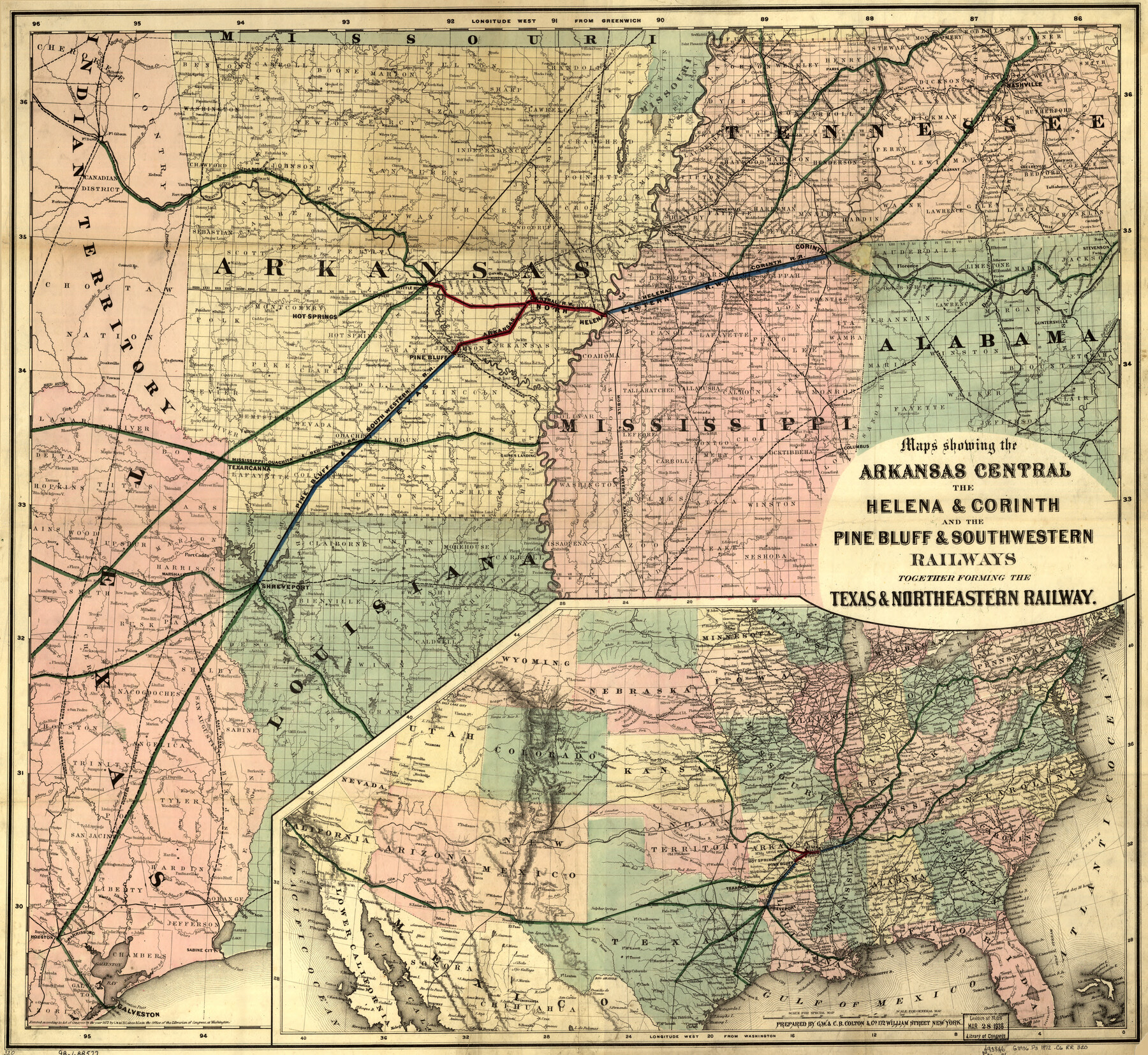
Maps showing Arkansas Central, the Helena & Corinth, and the Pine Bluff & Southwestern Railroads together forming the Texas & Northeastern Railway.
-
Map/Doc
93609
-
Collection
Library of Congress
-
Object Dates
1872 (Creation Date)
-
People and Organizations
G.W. & C.B. Colton & Co. (Publisher)
-
Subjects
Old Southwest Railroads
-
Height x Width
26.8 x 29.1 inches
68.1 x 73.9 cm
-
Comments
For more information see here. Prints available from the GLO courtesy of Library of Congress, Geography and Map Division.
Part of: Library of Congress


Map of Runnels Co[unty]
![88991, Map of Runnels Co[unty], Library of Congress](https://historictexasmaps.com/wmedia_w700/maps/88991.tif.jpg)
Print $20.00
Map of Runnels Co[unty]
1879
Size 24.5 x 18.2 inches
Map/Doc 88991
![88982, Motley Co[unty], Library of Congress](https://historictexasmaps.com/wmedia_w700/maps/88982.tif.jpg)
[Map showing T&P Lands in El Paso County]
![88936, [Map showing T&P Lands in El Paso County], Library of Congress](https://historictexasmaps.com/wmedia_w700/maps/88936.tif.jpg)
Print $20.00
[Map showing T&P Lands in El Paso County]
Size 22.6 x 17.5 inches
Map/Doc 88936
Red River County, Texas

Print $20.00
Red River County, Texas
1870
Size 22.4 x 17.3 inches
Map/Doc 88989
Map of McLennan Co[unty]
![88974, Map of McLennan Co[unty], Library of Congress](https://historictexasmaps.com/wmedia_w700/maps/88974.tif.jpg)
Print $40.00
Map of McLennan Co[unty]
1896
Size 47.9 x 53.6 inches
Map/Doc 88974
Map of the Rio Grande and Pecos Railway showing its connections with…

Print $20.00
Map of the Rio Grande and Pecos Railway showing its connections with…
1882
Size 42.1 x 40.2 inches
Map/Doc 93620
Map of the Military Department of the Gulf

Print $20.00
Map of the Military Department of the Gulf
1864
Size 24.4 x 45.7 inches
Map/Doc 93568

You may also like
Flight Mission No. BRE-1P, Frame 49, Nueces County

Print $20.00
- Digital $50.00
Flight Mission No. BRE-1P, Frame 49, Nueces County
1956
Size 18.4 x 22.2 inches
Map/Doc 86638
Canyon City,Texas, County Seat of Randall County

Print $20.00
- Digital $50.00
Canyon City,Texas, County Seat of Randall County
Size 20.3 x 25.1 inches
Map/Doc 92152
Flight Mission No. DAH-17M, Frame 64, Orange County

Print $20.00
- Digital $50.00
Flight Mission No. DAH-17M, Frame 64, Orange County
1953
Size 18.4 x 22.3 inches
Map/Doc 86898
Carson County Sketch File 3

Print $32.00
- Digital $50.00
Carson County Sketch File 3
1888
Size 5.4 x 8.4 inches
Map/Doc 17335
Wharton County Working Sketch 4

Print $20.00
- Digital $50.00
Wharton County Working Sketch 4
Size 16.3 x 21.3 inches
Map/Doc 72468
Sabine and Neches Rivers

Print $20.00
- Digital $50.00
Sabine and Neches Rivers
1973
Size 19.7 x 44.6 inches
Map/Doc 69818
Map of Orange County

Print $20.00
- Digital $50.00
Map of Orange County
1895
Size 15.5 x 16.2 inches
Map/Doc 3932
Jackson County Rolled Sketch 3

Print $20.00
- Digital $50.00
Jackson County Rolled Sketch 3
1913
Size 23.9 x 24.2 inches
Map/Doc 6336
Map of Chocolate Bay, west portion of West Bay & vicinity, Brazoria & Galveston Counties showing subdivision for mineral development

Print $40.00
- Digital $50.00
Map of Chocolate Bay, west portion of West Bay & vicinity, Brazoria & Galveston Counties showing subdivision for mineral development
1948
Size 42.2 x 55.2 inches
Map/Doc 2974
Connected Map of Austin's Colony

Print $40.00
- Digital $50.00
Connected Map of Austin's Colony
1837
Size 93.2 x 43.1 inches
Map/Doc 93376
Burnet County Sketch File 8

Print $22.00
- Digital $50.00
Burnet County Sketch File 8
Size 8.1 x 6.3 inches
Map/Doc 16689
[John Welch, W. F. Butter, and surrounding surveys]
![91011, [John Welch, W. F. Butter, and surrounding surveys], Twichell Survey Records](https://historictexasmaps.com/wmedia_w700/maps/91011-1.tif.jpg)
Print $3.00
- Digital $50.00
[John Welch, W. F. Butter, and surrounding surveys]
Size 17.1 x 10.9 inches
Map/Doc 91011