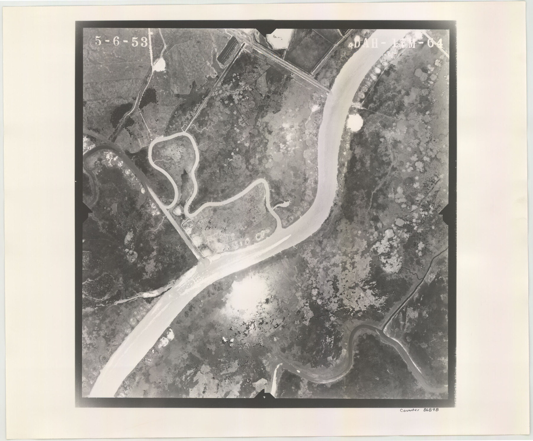
Flight Mission No. DAH-17M, Frame 64, Orange County
DAH-17M-64
-
Map/Doc
86898
-
Collection
General Map Collection
-
Object Dates
1953/5/6 (Creation Date)
-
People and Organizations
U. S. Department of Agriculture (Publisher)
-
Counties
Orange
-
Subjects
Aerial Photograph
-
Height x Width
18.4 x 22.3 inches
46.7 x 56.6 cm
-
Comments
Flown by Jack Ammann Photogrammetric Engineers of San Antonio, Texas.
Part of: General Map Collection
Madison County Working Sketch 14

Print $20.00
- Digital $50.00
Madison County Working Sketch 14
Size 24.9 x 17.0 inches
Map/Doc 78204
Reports of Committees, 23d Congress, 1st Session

Reports of Committees, 23d Congress, 1st Session
Size 9.2 x 6.0 inches
Map/Doc 95690

Flight Mission No. CRC-3R, Frame 19, Chambers County

Print $20.00
- Digital $50.00
Flight Mission No. CRC-3R, Frame 19, Chambers County
1956
Size 18.5 x 22.1 inches
Map/Doc 84793
[Surveys in Austin's Colony along the Navasota River and Ten Mile Creek]
![80, [Surveys in Austin's Colony along the Navasota River and Ten Mile Creek], General Map Collection](https://historictexasmaps.com/wmedia_w700/maps/80.tif.jpg)
Print $20.00
- Digital $50.00
[Surveys in Austin's Colony along the Navasota River and Ten Mile Creek]
1821
Size 29.2 x 18.0 inches
Map/Doc 80
Map of Houston & Overton Branch Railroad

Print $40.00
- Digital $50.00
Map of Houston & Overton Branch Railroad
1877
Size 22.3 x 110.1 inches
Map/Doc 64460
Hale County Sketch File 9

Print $14.00
- Digital $50.00
Hale County Sketch File 9
1893
Size 6.1 x 2.6 inches
Map/Doc 24730
Old Miscellaneous File 6

Print $4.00
- Digital $50.00
Old Miscellaneous File 6
1847
Size 4.2 x 7.6 inches
Map/Doc 75420
Kimble County Working Sketch 34

Print $20.00
- Digital $50.00
Kimble County Working Sketch 34
1945
Size 34.4 x 26.7 inches
Map/Doc 70102
Harris County Boundary File 1

Print $6.00
- Digital $50.00
Harris County Boundary File 1
1963
Size 9.2 x 11.2 inches
Map/Doc 54292
Clay County Boundary File 11

Print $12.00
- Digital $50.00
Clay County Boundary File 11
Size 14.0 x 8.4 inches
Map/Doc 51400
[Surveys along and below the Red River and the Lamar and Fannin County line, Lamar District]
![76049, [Surveys along and below the Red River and the Lamar and Fannin County line, Lamar District], General Map Collection](https://historictexasmaps.com/wmedia_w700/maps/76049.tif.jpg)
Print $3.00
- Digital $50.00
[Surveys along and below the Red River and the Lamar and Fannin County line, Lamar District]
Size 12.1 x 10.1 inches
Map/Doc 76049
You may also like

Flight Mission No. DQO-7K, Frame 107, Galveston County

Print $20.00
- Digital $50.00
Flight Mission No. DQO-7K, Frame 107, Galveston County
1952
Size 18.6 x 22.6 inches
Map/Doc 85122
Brooks County Rolled Sketch 25

Print $20.00
- Digital $50.00
Brooks County Rolled Sketch 25
1945
Size 21.6 x 26.4 inches
Map/Doc 5345
Irion County Rolled Sketch 17

Print $20.00
- Digital $50.00
Irion County Rolled Sketch 17
1956
Size 40.5 x 40.2 inches
Map/Doc 9255
Baylor County Sketch File A7

Print $6.00
- Digital $50.00
Baylor County Sketch File A7
1899
Size 9.1 x 14.6 inches
Map/Doc 14091
Menard County Rolled Sketch 6

Print $20.00
- Digital $50.00
Menard County Rolled Sketch 6
Size 17.3 x 21.2 inches
Map/Doc 6755
Hardin County Working Sketch 29

Print $20.00
- Digital $50.00
Hardin County Working Sketch 29
1958
Size 36.7 x 22.1 inches
Map/Doc 63427
Montgomery County Working Sketch 14

Print $20.00
- Digital $50.00
Montgomery County Working Sketch 14
1934
Size 18.5 x 20.1 inches
Map/Doc 71121
Andrews County Working Sketch Graphic Index

Print $40.00
- Digital $50.00
Andrews County Working Sketch Graphic Index
1951
Size 41.3 x 53.7 inches
Map/Doc 76453
Nolan County Working Sketch 9

Print $20.00
- Digital $50.00
Nolan County Working Sketch 9
1964
Size 25.0 x 36.8 inches
Map/Doc 71300
Montgomery County Rolled Sketch 50

Print $20.00
- Digital $50.00
Montgomery County Rolled Sketch 50
2016
Size 24.1 x 35.7 inches
Map/Doc 95685
