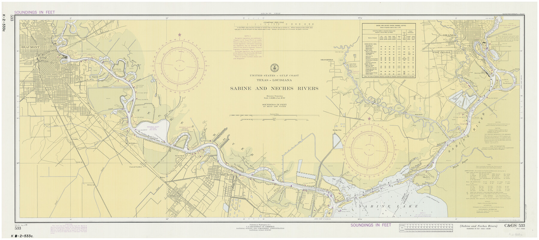
Sabine and Neches Rivers
K-2-533a
-
Map/Doc
69818
-
Collection
General Map Collection
-
Object Dates
1973/8/4 (Creation Date)
-
Counties
Orange Jefferson
-
Subjects
Nautical Charts
-
Height x Width
19.7 x 44.6 inches
50.0 x 113.3 cm
Part of: General Map Collection
Stephens County Working Sketch 15

Print $20.00
- Digital $50.00
Stephens County Working Sketch 15
1963
Size 35.8 x 36.8 inches
Map/Doc 63958
Jasper County Working Sketch 4

Print $20.00
- Digital $50.00
Jasper County Working Sketch 4
1905
Size 20.3 x 13.5 inches
Map/Doc 66466
Knox County Sketch File 2

Print $40.00
- Digital $50.00
Knox County Sketch File 2
1872
Size 26.5 x 38.0 inches
Map/Doc 76758
Rusk County Sketch File 17

Print $22.00
Rusk County Sketch File 17
1857
Size 12.7 x 15.7 inches
Map/Doc 35520
Ochiltree County

Print $20.00
- Digital $50.00
Ochiltree County
1958
Size 41.0 x 33.1 inches
Map/Doc 77386
Newton County Working Sketch 14

Print $20.00
- Digital $50.00
Newton County Working Sketch 14
1947
Size 22.3 x 21.9 inches
Map/Doc 71260
Marion County Rolled Sketch F

Print $40.00
- Digital $50.00
Marion County Rolled Sketch F
1937
Size 43.5 x 67.1 inches
Map/Doc 9487
Callahan County Working Sketch 15

Print $20.00
- Digital $50.00
Callahan County Working Sketch 15
2010
Size 22.6 x 27.3 inches
Map/Doc 89295
Brazoria County Sketch File 57

Print $10.00
- Digital $50.00
Brazoria County Sketch File 57
1940
Size 8.7 x 6.3 inches
Map/Doc 15377
Flight Mission No. DQO-8K, Frame 12, Galveston County

Print $20.00
- Digital $50.00
Flight Mission No. DQO-8K, Frame 12, Galveston County
1952
Size 18.7 x 22.4 inches
Map/Doc 85135
Duval County Sketch File 22

Print $20.00
- Digital $50.00
Duval County Sketch File 22
1880
Size 31.9 x 23.2 inches
Map/Doc 11386
Baylor County Boundary File 6

Print $82.00
- Digital $50.00
Baylor County Boundary File 6
Size 9.5 x 65.3 inches
Map/Doc 50400
You may also like
Copy of Surveyor's Field Book, Morris Browning - In Blocks 7, 5 & 4, I&GNRRCo., Hutchinson and Carson Counties, Texas

Print $2.00
- Digital $50.00
Copy of Surveyor's Field Book, Morris Browning - In Blocks 7, 5 & 4, I&GNRRCo., Hutchinson and Carson Counties, Texas
1888
Size 7.0 x 8.9 inches
Map/Doc 62277
Brazos County Working Sketch 7

Print $20.00
- Digital $50.00
Brazos County Working Sketch 7
1981
Size 12.1 x 33.1 inches
Map/Doc 67482
Political Essay on the Kingdom of New Spain Vol. 3

Political Essay on the Kingdom of New Spain Vol. 3
1822
Map/Doc 97388
Llano County Working Sketch 14

Print $20.00
- Digital $50.00
Llano County Working Sketch 14
1989
Size 14.6 x 34.7 inches
Map/Doc 70632
Culberson County Rolled Sketch 58

Print $40.00
- Digital $50.00
Culberson County Rolled Sketch 58
1979
Size 37.8 x 52.6 inches
Map/Doc 8759
Hartley County Boundary File 1a

Print $50.00
- Digital $50.00
Hartley County Boundary File 1a
Size 14.1 x 8.8 inches
Map/Doc 54437

Galveston County Rolled Sketch 27A

Print $20.00
- Digital $50.00
Galveston County Rolled Sketch 27A
1978
Size 32.2 x 35.5 inches
Map/Doc 5962
Map of Texas with population and location of principal towns and cities according to latest reliable statistics

Print $20.00
- Digital $50.00
Map of Texas with population and location of principal towns and cities according to latest reliable statistics
1908
Size 19.6 x 21.6 inches
Map/Doc 94068
San Patricio County NRC Article 33.136 Sketch 5

Print $20.00
- Digital $50.00
San Patricio County NRC Article 33.136 Sketch 5
2006
Size 36.0 x 24.0 inches
Map/Doc 94697

Crockett County Sketch File 96

Print $4.00
- Digital $50.00
Crockett County Sketch File 96
1934
Size 11.4 x 8.9 inches
Map/Doc 19964