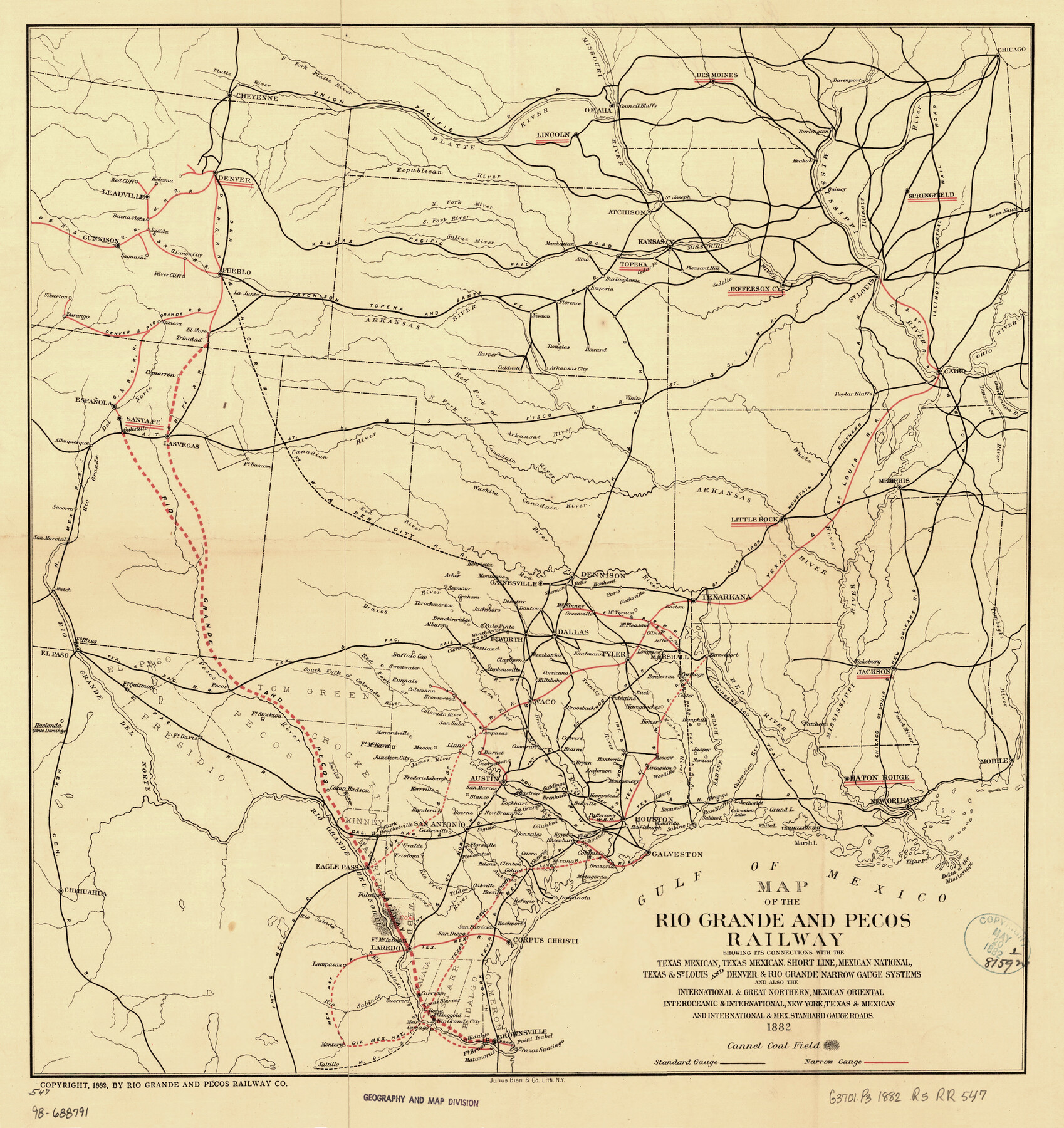
Map of the Rio Grande and Pecos Railway showing its connections with…
-
Map/Doc
93620
-
Collection
Library of Congress
-
Object Dates
1882 (Creation Date)
-
People and Organizations
Rio Grande and Pecos Railway Co. (Publisher)
-
Subjects
Old Southwest Railroads State of Texas
-
Height x Width
42.1 x 40.2 inches
106.9 x 102.1 cm
-
Comments
For more information see here. Prints available from the GLO courtesy of Library of Congress, Geography and Map Division.
Part of: Library of Congress
Map of Nolan County, Texas

Print $20.00
Map of Nolan County, Texas
1890
Size 24.4 x 19.3 inches
Map/Doc 88984
Map of the River Sabine from its Mouth on the Gulf of Mexico in the Sea to Logan's Ferry in Latitude 31°58'24" north

Print $40.00
Map of the River Sabine from its Mouth on the Gulf of Mexico in the Sea to Logan's Ferry in Latitude 31°58'24" north
1840
Size 35.0 x 170.0 inches
Map/Doc 88901
Denison, Grayson County, Texas, 1891

Print $20.00
Denison, Grayson County, Texas, 1891
1891
Size 23.9 x 36.4 inches
Map/Doc 93480
[Map showing T&P Lands in El Paso County]
![88937, [Map showing T&P Lands in El Paso County], Library of Congress](https://historictexasmaps.com/wmedia_w700/maps/88937.tif.jpg)
Print $20.00
[Map showing T&P Lands in El Paso County]
Size 22.3 x 17.3 inches
Map/Doc 88937
Bissell's railway junction point map of Texas / especially designed and adapted for the computation of shortline distances in the application of freight rates promulgated by the Railroad Commission of Texas.

Print $20.00
Bissell's railway junction point map of Texas / especially designed and adapted for the computation of shortline distances in the application of freight rates promulgated by the Railroad Commission of Texas.
1891
Size 31.5 x 26.8 inches
Map/Doc 93600
Butt's Map of Cooke County, Texas

Print $20.00
Butt's Map of Cooke County, Texas
1888
Size 17.5 x 14.5 inches
Map/Doc 88920
![88956, Hood Co[unty], Library of Congress](https://historictexasmaps.com/wmedia_w700/maps/88956.tif.jpg)
Carta General de la República Mexicana formada por Antonio García y Cubas

Print $40.00
Carta General de la República Mexicana formada por Antonio García y Cubas
1863
Size 48.7 x 57.1 inches
Map/Doc 95307
![88910, Bosque Co[unty], Library of Congress](https://historictexasmaps.com/wmedia_w700/maps/88910.tif.jpg)
Map of Llano County, Texas

Print $20.00
Map of Llano County, Texas
1879
Size 23.1 x 21.2 inches
Map/Doc 88970
Map of the military dep't of Texas : being a section of the map of the territory of the U.S. from the Mississippi River to the Pacific Ocean

Print $20.00
Map of the military dep't of Texas : being a section of the map of the territory of the U.S. from the Mississippi River to the Pacific Ocean
1859
Size 20.9 x 24.0 inches
Map/Doc 93596

You may also like
McCulloch County Rolled Sketch 7

Print $20.00
- Digital $50.00
McCulloch County Rolled Sketch 7
1982
Size 20.7 x 30.5 inches
Map/Doc 6718
Travis County Sketch File 22

Print $6.00
- Digital $50.00
Travis County Sketch File 22
1875
Size 8.5 x 8.5 inches
Map/Doc 38327
Lamb County Sketch File 9

Print $4.00
- Digital $50.00
Lamb County Sketch File 9
1910
Size 10.9 x 7.2 inches
Map/Doc 29358
Edwards County Boundary File 29

Print $22.00
- Digital $50.00
Edwards County Boundary File 29
Size 15.4 x 31.0 inches
Map/Doc 65502
Surveys in the Milam District at the fork of the Yegua and Brazos Rivers and on the Leon River

Print $2.00
- Digital $50.00
Surveys in the Milam District at the fork of the Yegua and Brazos Rivers and on the Leon River
1846
Size 9.2 x 16.0 inches
Map/Doc 254
Sabine River, West Extension Toll Bridge Sheet

Print $4.00
- Digital $50.00
Sabine River, West Extension Toll Bridge Sheet
1933
Size 15.2 x 19.3 inches
Map/Doc 65142
Oil and Gas Fields of the State of Texas

Print $40.00
- Digital $50.00
Oil and Gas Fields of the State of Texas
1931
Size 38.4 x 59.2 inches
Map/Doc 89885
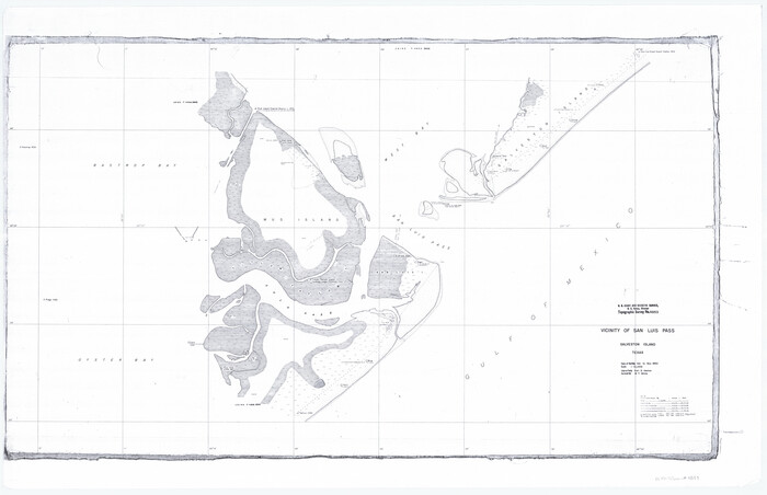
Vicinity of San Luis Pass, Galveston Island, Texas
Print $40.00
- Digital $50.00
Vicinity of San Luis Pass, Galveston Island, Texas
1933
Size 36.9 x 57.2 inches
Map/Doc 69942
Flight Mission No. DIX-5P, Frame 113, Aransas County

Print $20.00
- Digital $50.00
Flight Mission No. DIX-5P, Frame 113, Aransas County
1956
Size 17.6 x 17.7 inches
Map/Doc 83792
Presidio County Sketch File 105

Print $20.00
- Digital $50.00
Presidio County Sketch File 105
Size 13.1 x 20.6 inches
Map/Doc 82962
Polk County Working Sketch 11

Print $20.00
- Digital $50.00
Polk County Working Sketch 11
1940
Size 29.3 x 28.6 inches
Map/Doc 71626
[Southeast part of County near Jas. H. Price Survey]
![91888, [Southeast part of County near Jas. H. Price Survey], Twichell Survey Records](https://historictexasmaps.com/wmedia_w700/maps/91888-1.tif.jpg)
Print $20.00
- Digital $50.00
[Southeast part of County near Jas. H. Price Survey]
Size 19.3 x 19.3 inches
Map/Doc 91888