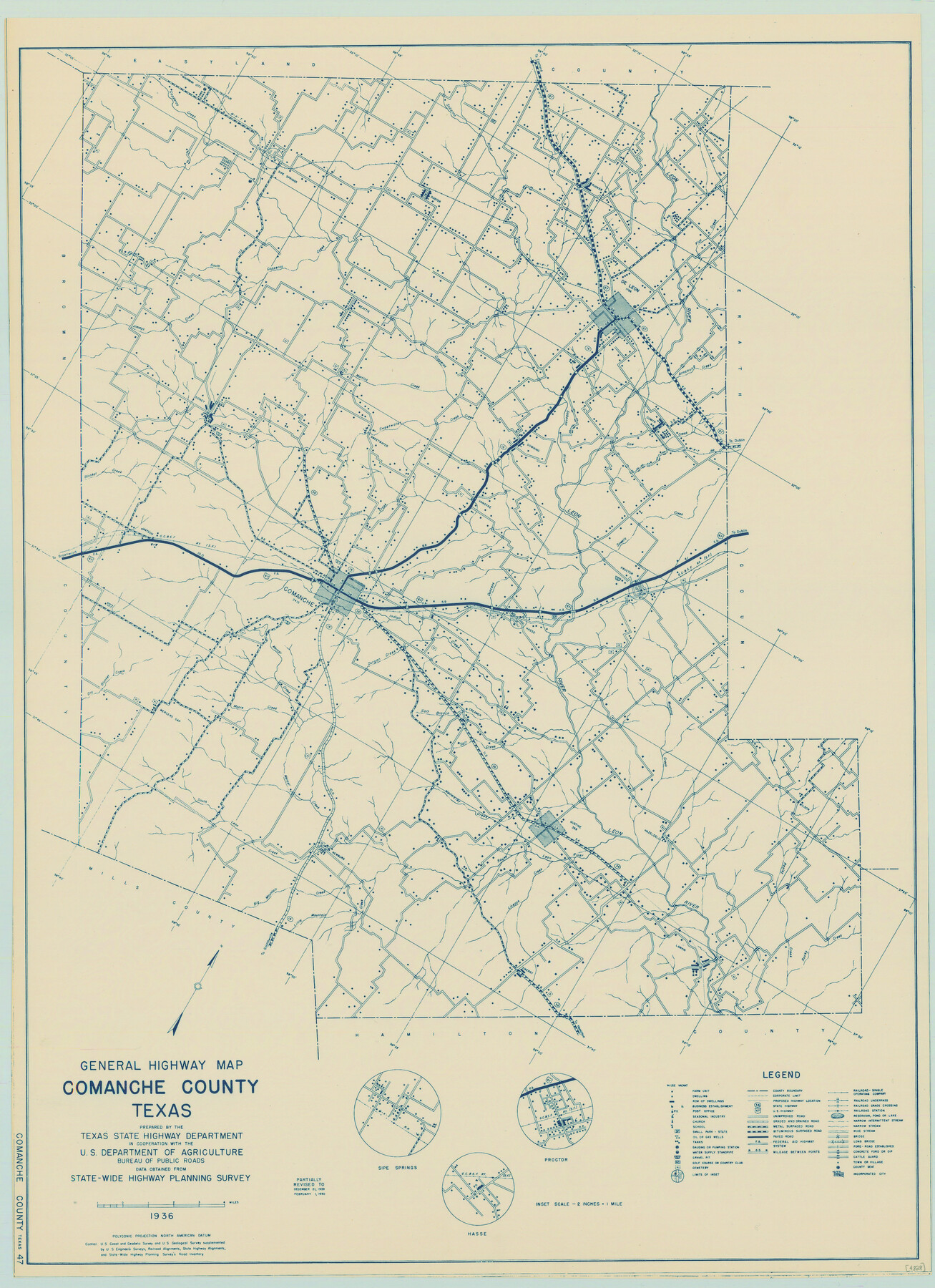
General Highway Map, Comanche County, Texas
-
Map/Doc
79056
-
Collection
Texas State Library and Archives
-
Object Dates
1940 (Creation Date)
-
People and Organizations
Texas State Highway Department (Publisher)
-
Counties
Comanche
-
Subjects
County
-
Height x Width
25.3 x 18.4 inches
64.3 x 46.7 cm
-
Comments
Prints available courtesy of the Texas State Library and Archives.
More info can be found here: TSLAC Map 04828
Part of: Texas State Library and Archives
Organizations for the Development of Texas Rivers

Print $20.00
Organizations for the Development of Texas Rivers
1938
Size 34.4 x 44.8 inches
Map/Doc 76307
General Highway Map, Hays County, Texas

Print $20.00
General Highway Map, Hays County, Texas
1961
Size 18.1 x 24.7 inches
Map/Doc 79513
General Highway Map, Bosque County, Texas

Print $20.00
General Highway Map, Bosque County, Texas
1940
Size 25.3 x 18.5 inches
Map/Doc 79022
General Highway Map, Henderson County, Texas

Print $20.00
General Highway Map, Henderson County, Texas
1961
Size 24.8 x 18.2 inches
Map/Doc 79516
General Highway Map, Anderson County, Texas

Print $20.00
General Highway Map, Anderson County, Texas
1961
Size 18.3 x 25.0 inches
Map/Doc 79346
General Highway Map, Newton County, Texas

Print $20.00
General Highway Map, Newton County, Texas
1961
Size 19.3 x 25.0 inches
Map/Doc 79613
General Highway Map, Loving County, Texas

Print $20.00
General Highway Map, Loving County, Texas
1940
Size 18.3 x 24.8 inches
Map/Doc 79179
General Highway Map, Johnson County, Texas

Print $20.00
General Highway Map, Johnson County, Texas
1961
Size 18.2 x 24.8 inches
Map/Doc 79545
General Highway Map, Crosby County, Texas

Print $20.00
General Highway Map, Crosby County, Texas
1961
Size 18.1 x 24.5 inches
Map/Doc 79426
General Highway Map, Foard County, Texas

Print $20.00
General Highway Map, Foard County, Texas
1961
Size 18.2 x 24.6 inches
Map/Doc 79468
General Highway Map, Stonewall County, Texas

Print $20.00
General Highway Map, Stonewall County, Texas
1940
Size 18.3 x 24.8 inches
Map/Doc 79249
Map of Texas compiled from surveys recorded in the Land Office of Texas, and other official surveys

Print $20.00
Map of Texas compiled from surveys recorded in the Land Office of Texas, and other official surveys
1841
Size 25.1 x 20.4 inches
Map/Doc 76253
You may also like
Polk County Working Sketch 23b

Print $40.00
- Digital $50.00
Polk County Working Sketch 23b
1957
Size 28.8 x 54.6 inches
Map/Doc 71639
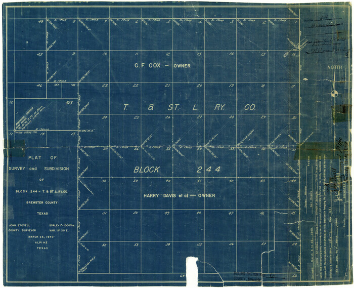
Brewster County Rolled Sketch 64
Print $20.00
- Digital $50.00
Brewster County Rolled Sketch 64
1940
Size 17.1 x 21.0 inches
Map/Doc 5232
Navigation Maps of Gulf Intracoastal Waterway, Port Arthur to Brownsville, Texas

Print $4.00
- Digital $50.00
Navigation Maps of Gulf Intracoastal Waterway, Port Arthur to Brownsville, Texas
1951
Size 16.7 x 21.4 inches
Map/Doc 65446
Crockett County Sketch File 15

Print $24.00
- Digital $50.00
Crockett County Sketch File 15
1880
Size 9.1 x 8.0 inches
Map/Doc 19666
The Texas Co-Ordinate System, Title 86 Art. 5300A

Print $20.00
- Digital $50.00
The Texas Co-Ordinate System, Title 86 Art. 5300A
1943
Size 27.7 x 30.3 inches
Map/Doc 3122
Uvalde County Working Sketch 68

Print $20.00
- Digital $50.00
Uvalde County Working Sketch 68
1971
Size 30.3 x 32.0 inches
Map/Doc 75974
[Sketch showing Leagues 464, 467-472, 483-489, 495, 510, 517, 532, 541, 556-570]
![89802, [Sketch showing Leagues 464, 467-472, 483-489, 495, 510, 517, 532, 541, 556-570], Twichell Survey Records](https://historictexasmaps.com/wmedia_w700/maps/89802-1.tif.jpg)
Print $20.00
- Digital $50.00
[Sketch showing Leagues 464, 467-472, 483-489, 495, 510, 517, 532, 541, 556-570]
Size 44.8 x 42.7 inches
Map/Doc 89802
Die Eisenbahm von dem Missisippi nach dem stillen Ocean (Californien)

Print $20.00
- Digital $50.00
Die Eisenbahm von dem Missisippi nach dem stillen Ocean (Californien)
1856
Size 14.0 x 14.8 inches
Map/Doc 94075
Lyons Subdivision

Print $20.00
- Digital $50.00
Lyons Subdivision
1946
Size 17.5 x 16.3 inches
Map/Doc 92429
Titus County Sketch File 7

Print $4.00
- Digital $50.00
Titus County Sketch File 7
1853
Size 10.0 x 8.2 inches
Map/Doc 38142
Refugio County Working Sketch 3

Print $20.00
- Digital $50.00
Refugio County Working Sketch 3
1927
Size 21.9 x 24.6 inches
Map/Doc 63512
Kleberg County Rolled Sketch 10-21

Print $20.00
- Digital $50.00
Kleberg County Rolled Sketch 10-21
1952
Size 37.5 x 32.9 inches
Map/Doc 9403