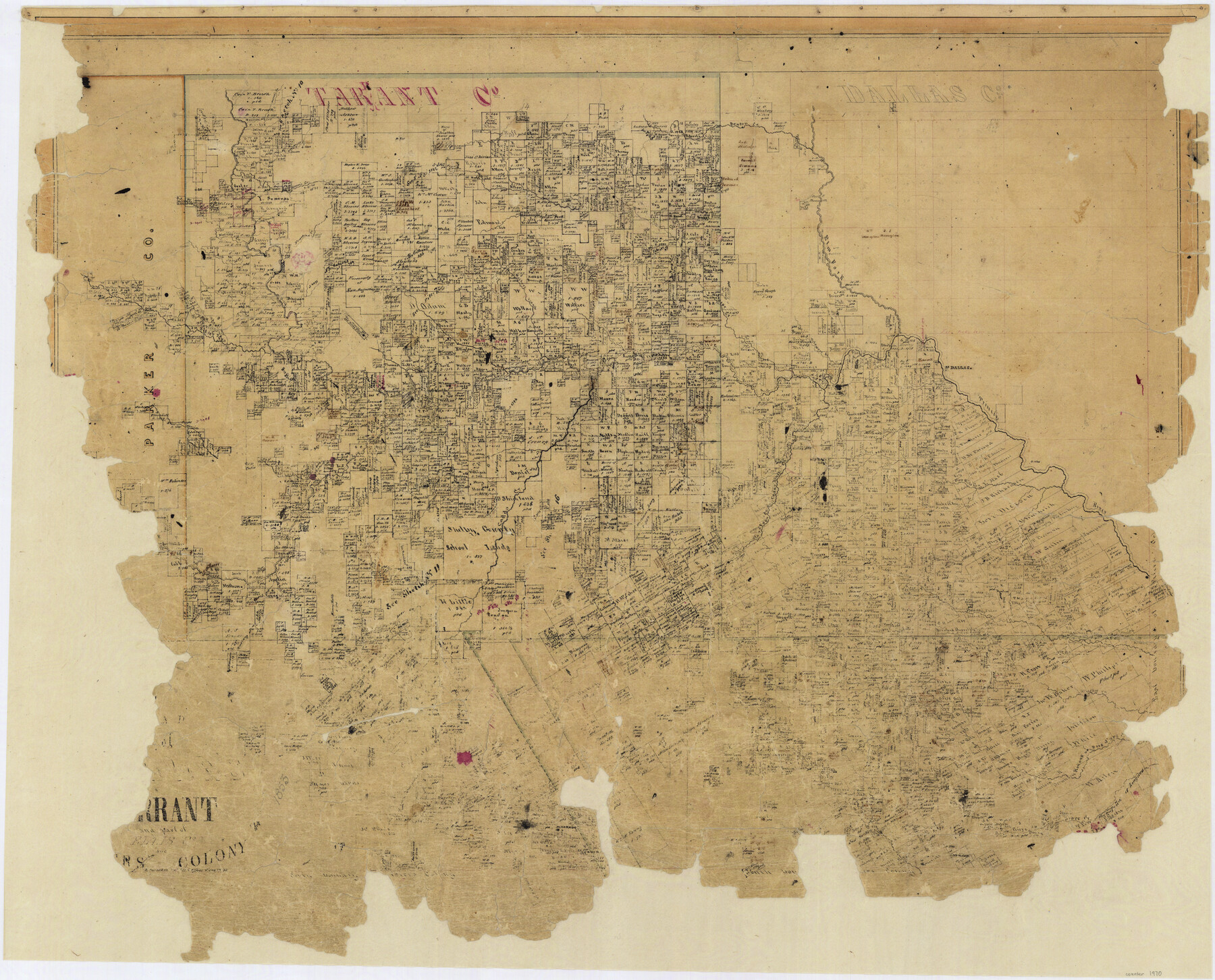
Map of Dallas, Tarrant and part of Ellis County and Peters Colony
N-2-54
-
Map/Doc
1970
-
Collection
General Map Collection
-
Object Dates
1853/6/27 (Creation Date)
-
Counties
Tarrant Dallas Ellis
-
Subjects
County
-
Height x Width
25.8 x 32.0 inches
65.5 x 81.3 cm
-
Comments
Conservation funded in 2002 with donation from Raymond L. Goodson Jr., Incorporated.
-
Features
Pleasant Creek
Trinity River
Dallas
Five Mile Creek
Gilbert's Creek
Mountain Creek
Cedar Bluff Creek
Ten Miles Creek
Brushy Creek
Delaware Branch of Trinity River
Deer Creek
Mustang Creek
Red Oak Creek
Bois D'Arc Creek
Grove Creek
Alvarado
Birdville
Fort Worth
Walnut Creek
Dunham's Creek
Gilmore's Creek
Bear Creek
Denton Creek
Elm Fork of Trinity River
Caddo Creek
Walker's Branch of Caddo Creek
Fraction Creek
Durret's Creek
Ash Creek
Silver Creek
Mill Creek
Hush Creek
Live Oak Creek
Main Creek
Cottonwood Creek
Mary's Creek
Part of: General Map Collection
Navarro County Working Sketch 9

Print $20.00
- Digital $50.00
Navarro County Working Sketch 9
1956
Size 22.8 x 20.6 inches
Map/Doc 71239
Karnes County Sketch File 10

Print $10.00
- Digital $50.00
Karnes County Sketch File 10
1885
Size 12.8 x 8.5 inches
Map/Doc 28597
Dallas County Boundary File 7 and 7a and 7b

Print $8.00
- Digital $50.00
Dallas County Boundary File 7 and 7a and 7b
Size 11.2 x 8.6 inches
Map/Doc 52291
Flight Mission No. DCL-6C, Frame 79, Kenedy County

Print $20.00
- Digital $50.00
Flight Mission No. DCL-6C, Frame 79, Kenedy County
1943
Size 18.6 x 22.4 inches
Map/Doc 85921
[Map of Connecting Lines along or near the Red River]
![75545, [Map of Connecting Lines along or near the Red River], General Map Collection](https://historictexasmaps.com/wmedia_w700/maps/75545.tif.jpg)
Print $40.00
- Digital $50.00
[Map of Connecting Lines along or near the Red River]
Size 37.9 x 48.7 inches
Map/Doc 75545
Crosby County Rolled Sketch 1

Print $20.00
- Digital $50.00
Crosby County Rolled Sketch 1
1950
Size 25.3 x 21.1 inches
Map/Doc 5640
Flight Mission No. DQN-1K, Frame 131, Calhoun County

Print $20.00
- Digital $50.00
Flight Mission No. DQN-1K, Frame 131, Calhoun County
1953
Size 18.6 x 22.4 inches
Map/Doc 84194
Chambers County Sketch File 34

Print $10.00
- Digital $50.00
Chambers County Sketch File 34
1951
Size 14.3 x 8.8 inches
Map/Doc 17620
Leon County Working Sketch 35

Print $20.00
- Digital $50.00
Leon County Working Sketch 35
1978
Size 43.8 x 38.3 inches
Map/Doc 70434
Wichita County Sketch File 27

Print $52.00
- Digital $50.00
Wichita County Sketch File 27
1925
Size 9.1 x 7.9 inches
Map/Doc 40114
Burnet County Sketch File 30

Print $4.00
- Digital $50.00
Burnet County Sketch File 30
Size 11.0 x 8.0 inches
Map/Doc 16746
Red River County Rolled Sketch 7A

Print $20.00
- Digital $50.00
Red River County Rolled Sketch 7A
Size 28.3 x 33.1 inches
Map/Doc 7472
You may also like
Sabine Pass, Series No. 519

Print $20.00
- Digital $50.00
Sabine Pass, Series No. 519
1888
Size 27.3 x 21.6 inches
Map/Doc 69841
Upton County Rolled Sketch 21

Print $20.00
- Digital $50.00
Upton County Rolled Sketch 21
1939
Size 21.5 x 37.9 inches
Map/Doc 8072
Williamson County Sketch File 19

Print $24.00
- Digital $50.00
Williamson County Sketch File 19
Size 12.8 x 8.0 inches
Map/Doc 40345
Map of San Patricio County

Print $40.00
- Digital $50.00
Map of San Patricio County
1896
Size 31.6 x 51.2 inches
Map/Doc 63018
Map of Texas from the most recent authorities

Print $20.00
Map of Texas from the most recent authorities
1845
Size 13.5 x 17.1 inches
Map/Doc 94574
Ochiltree County Boundary File 5b

Print $4.00
- Digital $50.00
Ochiltree County Boundary File 5b
Size 13.7 x 8.7 inches
Map/Doc 57697
Plan of the City of Austin

Print $20.00
Plan of the City of Austin
1853
Size 13.9 x 11.5 inches
Map/Doc 76207
Nueces County NRC Article 33.136 Sketch 20

Print $36.00
- Digital $50.00
Nueces County NRC Article 33.136 Sketch 20
2021
Map/Doc 96887
Eastland County Working Sketch 29

Print $20.00
- Digital $50.00
Eastland County Working Sketch 29
1952
Size 21.1 x 22.3 inches
Map/Doc 68810
Zapata County Working Sketch 10

Print $20.00
- Digital $50.00
Zapata County Working Sketch 10
1954
Size 33.9 x 32.2 inches
Map/Doc 62061
Coast of Texas and its defences

Print $20.00
- Digital $50.00
Coast of Texas and its defences
Size 27.6 x 18.2 inches
Map/Doc 72685
Cottle County Working Sketch 21

Print $20.00
- Digital $50.00
Cottle County Working Sketch 21
1982
Size 37.0 x 46.6 inches
Map/Doc 68331