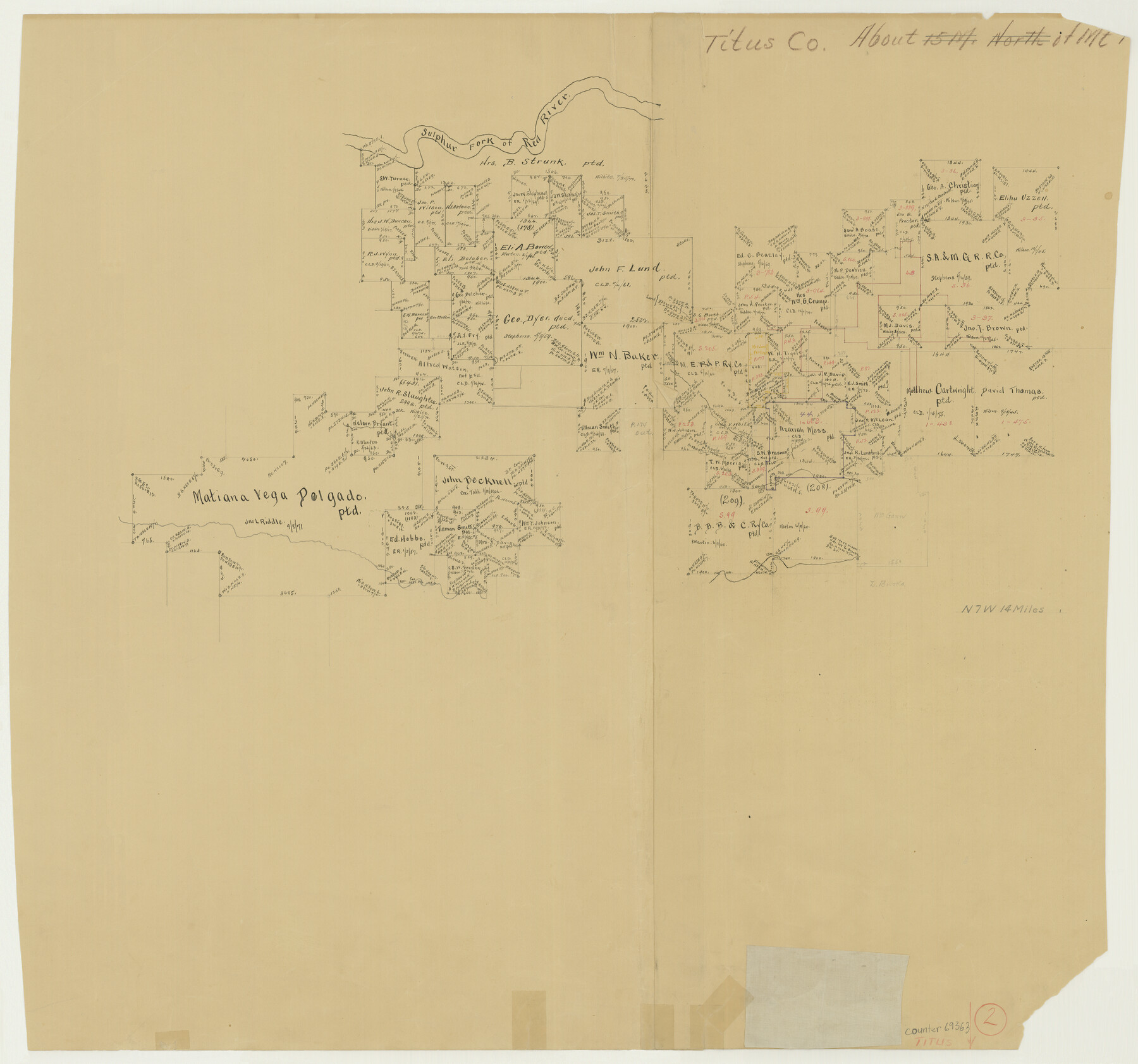
Titus County Working Sketch 2
-
Map/Doc
69363
-
Collection
General Map Collection
-
Counties
Titus
-
Subjects
Surveying Working Sketch
-
Height x Width
23.6 x 25.3 inches
59.9 x 64.3 cm
Part of: General Map Collection
Map of the country in the vicinity of San Antonio de Bexar reduced in part from the county map of Bexar with additions by J. Edmd. Blake, 1st Lieut Topl. Engs.

Print $20.00
- Digital $50.00
Map of the country in the vicinity of San Antonio de Bexar reduced in part from the county map of Bexar with additions by J. Edmd. Blake, 1st Lieut Topl. Engs.
1845
Size 18.1 x 25.7 inches
Map/Doc 72722
Map of Falls County

Print $20.00
- Digital $50.00
Map of Falls County
1874
Size 19.8 x 22.6 inches
Map/Doc 3530
Hudspeth County Working Sketch 57

Print $20.00
- Digital $50.00
Hudspeth County Working Sketch 57
1992
Size 9.6 x 26.5 inches
Map/Doc 66342
McLennan County Sketch File 1

Print $4.00
- Digital $50.00
McLennan County Sketch File 1
Size 11.5 x 8.4 inches
Map/Doc 31224
Lampasas County Working Sketch 22

Print $20.00
- Digital $50.00
Lampasas County Working Sketch 22
1993
Size 34.5 x 34.7 inches
Map/Doc 70300
Terrell County Working Sketch 83

Print $20.00
- Digital $50.00
Terrell County Working Sketch 83
1992
Size 22.0 x 35.9 inches
Map/Doc 69604
Tyler County Rolled Sketch 5

Print $20.00
- Digital $50.00
Tyler County Rolled Sketch 5
1954
Size 29.3 x 40.0 inches
Map/Doc 8057
Upshur County Sketch File 7

Print $4.00
- Digital $50.00
Upshur County Sketch File 7
1849
Size 8.2 x 10.2 inches
Map/Doc 38744
Edwards County Rolled Sketch 37

Print $20.00
- Digital $50.00
Edwards County Rolled Sketch 37
2018
Size 23.3 x 30.2 inches
Map/Doc 94459
North end of Brazos Island

Print $20.00
- Digital $50.00
North end of Brazos Island
Size 26.0 x 18.2 inches
Map/Doc 72916
Chambers County Sketch File 35a

Print $31.00
- Digital $50.00
Chambers County Sketch File 35a
1935
Size 15.4 x 9.1 inches
Map/Doc 17632
[Cotton Belt, St. Louis Southwestern Railway of Texas, Alignment through Smith County]
![64383, [Cotton Belt, St. Louis Southwestern Railway of Texas, Alignment through Smith County], General Map Collection](https://historictexasmaps.com/wmedia_w700/maps/64383.tif.jpg)
Print $20.00
- Digital $50.00
[Cotton Belt, St. Louis Southwestern Railway of Texas, Alignment through Smith County]
1903
Size 21.5 x 29.4 inches
Map/Doc 64383
You may also like
Atascosa County Sketch File 3a

Print $6.00
- Digital $50.00
Atascosa County Sketch File 3a
1856
Size 7.1 x 8.8 inches
Map/Doc 13736

Dimmit County Sketch File 14

Print $20.00
- Digital $50.00
Dimmit County Sketch File 14
1884
Size 35.7 x 23.3 inches
Map/Doc 11342
Flight Mission No. BRA-16M, Frame 181, Jefferson County

Print $20.00
- Digital $50.00
Flight Mission No. BRA-16M, Frame 181, Jefferson County
1953
Size 18.6 x 22.2 inches
Map/Doc 85779
Hopkins County Rolled Sketch 28

Print $20.00
- Digital $50.00
Hopkins County Rolled Sketch 28
Size 25.3 x 19.9 inches
Map/Doc 6225

Borden - Garza County Line as agreed upon in the 118th Judicial District Court, Howard County, Texas Case No. 13,023

Print $40.00
- Digital $50.00
Borden - Garza County Line as agreed upon in the 118th Judicial District Court, Howard County, Texas Case No. 13,023
1965
Size 19.0 x 102.2 inches
Map/Doc 1697
Hood County Boundary File 40

Print $44.00
- Digital $50.00
Hood County Boundary File 40
Size 14.4 x 8.8 inches
Map/Doc 55019
Stonewall County Working Sketch Graphic Index - sheet B

Print $20.00
- Digital $50.00
Stonewall County Working Sketch Graphic Index - sheet B
1933
Size 43.7 x 36.6 inches
Map/Doc 83172
[Block B9 and 3KA]
![90329, [Block B9 and 3KA], Twichell Survey Records](https://historictexasmaps.com/wmedia_w700/maps/90329-1.tif.jpg)
Print $20.00
- Digital $50.00
[Block B9 and 3KA]
Size 31.4 x 17.8 inches
Map/Doc 90329
Ochiltree County

Print $20.00
- Digital $50.00
Ochiltree County
1908
Size 42.5 x 40.6 inches
Map/Doc 66959
Flight Mission No. BQY-4M, Frame 44, Harris County

Print $20.00
- Digital $50.00
Flight Mission No. BQY-4M, Frame 44, Harris County
1953
Size 18.5 x 22.4 inches
Map/Doc 85259