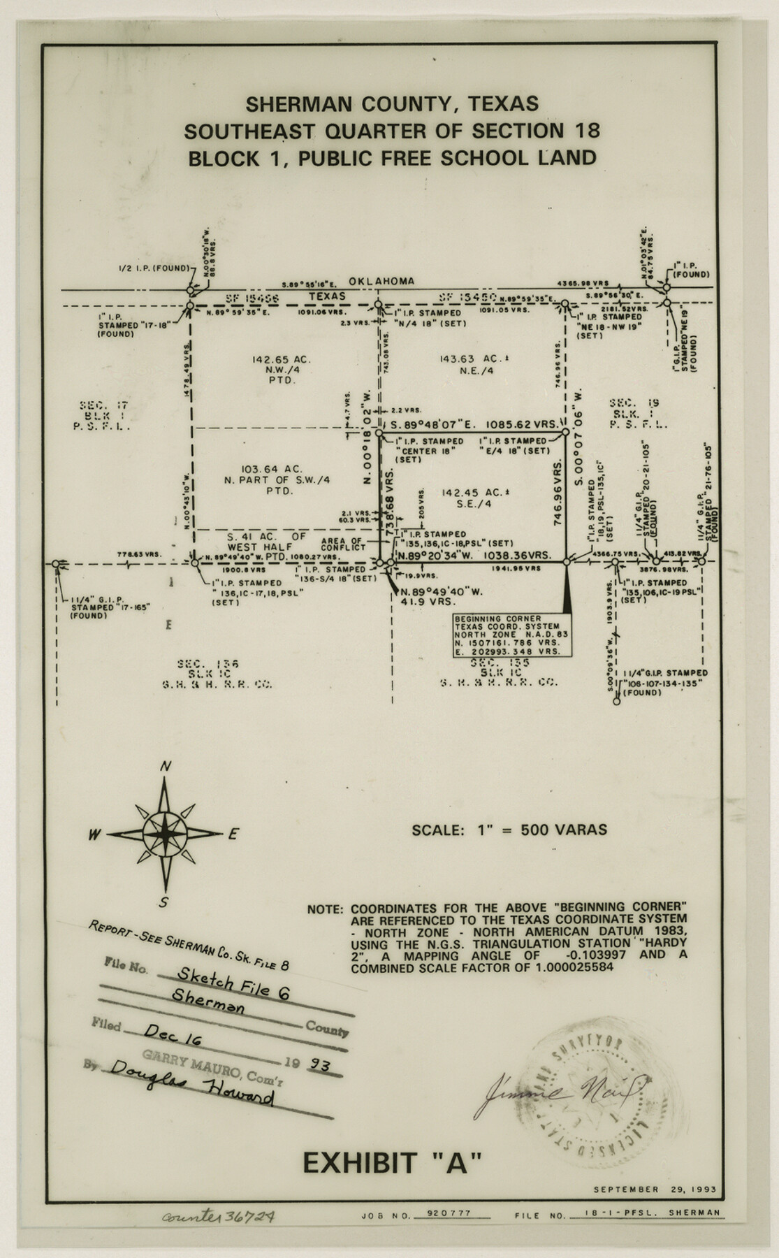
Sherman County Sketch File 6
[Sketch of southeast 1/4 of section 18, Block 1, Public Free School Land]
-
Map/Doc
36724
-
Collection
General Map Collection
-
Object Dates
9/29/1993 (Creation Date)
12/16/1993 (File Date)
-
People and Organizations
Jimmie Nail (Surveyor/Engineer)
-
Counties
Sherman
-
Subjects
Surveying Sketch File
-
Height x Width
14.6 x 9.1 inches
37.1 x 23.1 cm
-
Medium
mylar, print
-
Scale
1" = 500 varas
-
Comments
See Sherman County Sketch File 8 (36726) for report.
Related maps
Sherman County Sketch File 8

Print $61.00
- Digital $50.00
Sherman County Sketch File 8
1993
Size 11.4 x 8.9 inches
Map/Doc 36726
Part of: General Map Collection
Map of McClennan County

Print $20.00
- Digital $50.00
Map of McClennan County
1855
Size 22.7 x 24.7 inches
Map/Doc 3860
Erath County Rolled Sketch 3

Print $20.00
- Digital $50.00
Erath County Rolled Sketch 3
1982
Size 22.6 x 27.9 inches
Map/Doc 5864
Wood County Working Sketch 19

Print $20.00
- Digital $50.00
Wood County Working Sketch 19
1982
Size 25.8 x 24.8 inches
Map/Doc 62019
Flight Mission No. BRA-7M, Frame 39, Jefferson County

Print $20.00
- Digital $50.00
Flight Mission No. BRA-7M, Frame 39, Jefferson County
1953
Size 18.7 x 22.5 inches
Map/Doc 85490
Jones County Rolled Sketch 4

Print $20.00
- Digital $50.00
Jones County Rolled Sketch 4
2022
Size 31.9 x 24.0 inches
Map/Doc 97150
Hays County Rolled Sketch 30

Print $20.00
- Digital $50.00
Hays County Rolled Sketch 30
1966
Size 33.1 x 36.6 inches
Map/Doc 9150
Ward County Working Sketch 12

Print $20.00
- Digital $50.00
Ward County Working Sketch 12
1947
Size 23.4 x 22.7 inches
Map/Doc 72318
Presidio County Working Sketch 88

Print $20.00
- Digital $50.00
Presidio County Working Sketch 88
1971
Size 46.9 x 37.7 inches
Map/Doc 71765
Map of Location of the Pecos & Northern Texas Railway from Station 5868+52 to Station 7879+36 = 38.08 Miles through Parmer County, Texas

Print $40.00
- Digital $50.00
Map of Location of the Pecos & Northern Texas Railway from Station 5868+52 to Station 7879+36 = 38.08 Miles through Parmer County, Texas
Size 20.2 x 108.5 inches
Map/Doc 64090
Mills County Sketch File 23

Print $4.00
- Digital $50.00
Mills County Sketch File 23
Size 12.4 x 9.2 inches
Map/Doc 31672
Collingsworth County

Print $20.00
- Digital $50.00
Collingsworth County
1971
Size 42.7 x 35.8 inches
Map/Doc 95460
Harris County Sketch File AA3

Print $8.00
- Digital $50.00
Harris County Sketch File AA3
Size 8.2 x 8.5 inches
Map/Doc 25326
You may also like
Kleberg County Rolled Sketch 10-9

Print $20.00
- Digital $50.00
Kleberg County Rolled Sketch 10-9
1952
Size 37.1 x 33.1 inches
Map/Doc 9387
[Area around Edwin Harry survey 475, Chas. H. Smith survey 105 and A. M Fuqua survey 463]
![90423, [Area around Edwin Harry survey 475, Chas. H. Smith survey 105 and A. M Fuqua survey 463], Twichell Survey Records](https://historictexasmaps.com/wmedia_w700/maps/90423-1.tif.jpg)
Print $20.00
- Digital $50.00
[Area around Edwin Harry survey 475, Chas. H. Smith survey 105 and A. M Fuqua survey 463]
Size 21.0 x 15.6 inches
Map/Doc 90423
Flight Mission No. BQY-4M, Frame 115, Harris County

Print $20.00
- Digital $50.00
Flight Mission No. BQY-4M, Frame 115, Harris County
1953
Size 18.6 x 22.5 inches
Map/Doc 85282
Sulphur River, Bassett Sheet

Print $20.00
- Digital $50.00
Sulphur River, Bassett Sheet
1939
Size 25.3 x 32.0 inches
Map/Doc 78320
Goliad County Rolled Sketch 2

Print $20.00
- Digital $50.00
Goliad County Rolled Sketch 2
1944
Size 33.1 x 34.6 inches
Map/Doc 9010
Guadalupe County

Print $20.00
- Digital $50.00
Guadalupe County
1854
Size 25.0 x 21.1 inches
Map/Doc 3609
Nacogdoches County Boundary File 1

Print $36.00
- Digital $50.00
Nacogdoches County Boundary File 1
Size 6.7 x 4.4 inches
Map/Doc 57562
Upton County Working Sketch 33

Print $20.00
- Digital $50.00
Upton County Working Sketch 33
1955
Size 17.9 x 37.8 inches
Map/Doc 69529
Block 11, Capitol Syndicate Subdivision of Capitol Land Reservation Leagues

Print $20.00
- Digital $50.00
Block 11, Capitol Syndicate Subdivision of Capitol Land Reservation Leagues
Size 25.0 x 26.2 inches
Map/Doc 90737
Webb County Rolled Sketch 22

Print $40.00
- Digital $50.00
Webb County Rolled Sketch 22
Size 108.0 x 43.7 inches
Map/Doc 10120
Cooke County Sketch File 19

Print $8.00
- Digital $50.00
Cooke County Sketch File 19
1861
Size 7.9 x 6.1 inches
Map/Doc 19260
Controlled Mosaic by Jack Amman Photogrammetric Engineers, Inc - Sheet 7

Print $20.00
- Digital $50.00
Controlled Mosaic by Jack Amman Photogrammetric Engineers, Inc - Sheet 7
1954
Size 20.0 x 24.0 inches
Map/Doc 83451