Leon County Sketch File 7
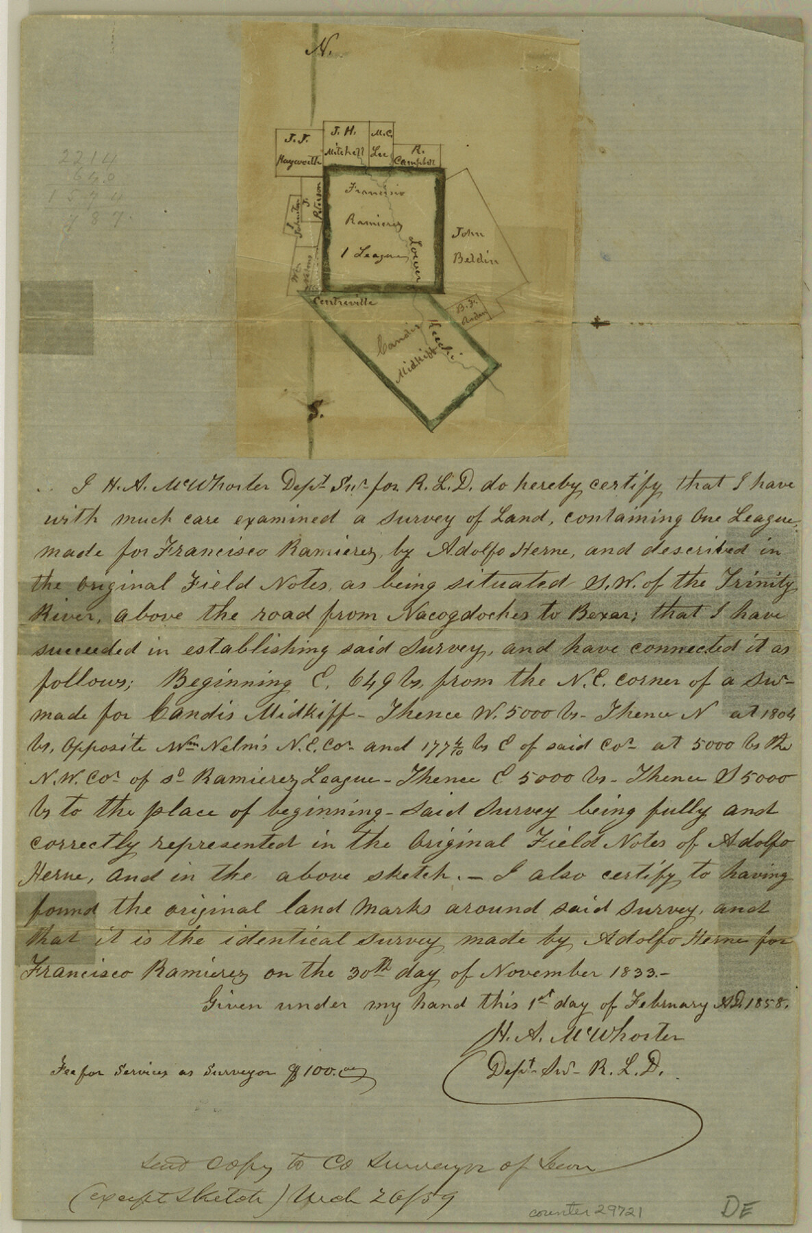
[Field notes of a resurvey of the Francisco Ramirez league]
-
Map/Doc
29721
-
Collection
General Map Collection
-
Object Dates
2/1/1858 (Creation Date)
3/31/1860 (File Date)
-
People and Organizations
H.A. McWhorter (Surveyor/Engineer)
-
Counties
Leon
-
Subjects
Surveying Sketch File
-
Height x Width
12.4 x 8.2 inches
31.5 x 20.8 cm
-
Medium
paper, manuscript
Part of: General Map Collection
Uvalde County Working Sketch 28

Print $20.00
- Digital $50.00
Uvalde County Working Sketch 28
1957
Size 25.9 x 21.5 inches
Map/Doc 72098
Wharton County Working Sketch 11

Print $20.00
- Digital $50.00
Wharton County Working Sketch 11
1976
Size 42.2 x 40.8 inches
Map/Doc 72475
Galveston County NRC Article 33.136 Sketch 83

Print $52.00
- Digital $50.00
Galveston County NRC Article 33.136 Sketch 83
2016
Size 22.5 x 34.0 inches
Map/Doc 94968
Mills County Sketch File 25

Print $8.00
- Digital $50.00
Mills County Sketch File 25
1949
Size 11.3 x 8.8 inches
Map/Doc 31674
San Jacinto County Sketch File 10

Print $5.00
San Jacinto County Sketch File 10
1859
Size 11.7 x 6.6 inches
Map/Doc 35714
Cochran County

Print $20.00
- Digital $50.00
Cochran County
1946
Size 33.3 x 25.5 inches
Map/Doc 95456
Map of the Fort Worth & Denver City Railway

Print $40.00
- Digital $50.00
Map of the Fort Worth & Denver City Railway
1887
Size 21.7 x 72.8 inches
Map/Doc 64479
Chambers County Sketch File 27

Print $12.00
- Digital $50.00
Chambers County Sketch File 27
1934
Size 11.3 x 8.8 inches
Map/Doc 17606
Houston County Sketch File 36

Print $40.00
- Digital $50.00
Houston County Sketch File 36
1945
Size 15.6 x 14.2 inches
Map/Doc 26817
Comanche County Working Sketch 5

Print $20.00
- Digital $50.00
Comanche County Working Sketch 5
1919
Size 31.8 x 28.9 inches
Map/Doc 68139
Kimble County Working Sketch 92

Print $20.00
- Digital $50.00
Kimble County Working Sketch 92
1979
Size 24.0 x 30.6 inches
Map/Doc 70160
Culberson County Rolled Sketch 52

Print $20.00
- Digital $50.00
Culberson County Rolled Sketch 52
Size 19.2 x 25.1 inches
Map/Doc 5674
You may also like
Flight Mission No. DQO-2K, Frame 149, Galveston County

Print $20.00
- Digital $50.00
Flight Mission No. DQO-2K, Frame 149, Galveston County
1952
Size 18.8 x 22.4 inches
Map/Doc 85046
[Sketch showing surveys near Brushy Creek and Old Thrall Oil Field]
![90421, [Sketch showing surveys near Brushy Creek and Old Thrall Oil Field], Twichell Survey Records](https://historictexasmaps.com/wmedia_w700/maps/90421-1.tif.jpg)
Print $20.00
- Digital $50.00
[Sketch showing surveys near Brushy Creek and Old Thrall Oil Field]
Size 27.4 x 42.6 inches
Map/Doc 90421
The Chief Justice County of Harrisburg. Lands in Conflict with Brazoria, Liberty Counties

Print $20.00
The Chief Justice County of Harrisburg. Lands in Conflict with Brazoria, Liberty Counties
2020
Size 17.5 x 21.7 inches
Map/Doc 96050
Gonzales County

Print $40.00
- Digital $50.00
Gonzales County
1986
Size 41.6 x 54.7 inches
Map/Doc 73160
La Florida / Peruviae Avriferæ Regionis Typus / Guastecan

Print $20.00
- Digital $50.00
La Florida / Peruviae Avriferæ Regionis Typus / Guastecan
1584
Size 16.8 x 20.9 inches
Map/Doc 94100
Jeff Davis County Rolled Sketch 16

Print $20.00
- Digital $50.00
Jeff Davis County Rolled Sketch 16
Size 27.1 x 31.7 inches
Map/Doc 6369
Flight Mission No. BRE-2P, Frame 50, Nueces County

Print $20.00
- Digital $50.00
Flight Mission No. BRE-2P, Frame 50, Nueces County
1956
Size 18.5 x 22.4 inches
Map/Doc 86752

La Salle County Working Sketch 36

Print $20.00
- Digital $50.00
La Salle County Working Sketch 36
1958
Size 18.8 x 42.6 inches
Map/Doc 70337
[Atlas A, Table of Contents, part 2]
![82085, [Atlas A, Table of Contents, part 2], General Map Collection](https://historictexasmaps.com/wmedia_w700/maps/82085.tif.jpg)
Print $2.00
- Digital $50.00
[Atlas A, Table of Contents, part 2]
Size 7.0 x 11.8 inches
Map/Doc 82085
Wharton County Working Sketch 9

Print $3.00
- Digital $50.00
Wharton County Working Sketch 9
1982
Size 12.4 x 10.4 inches
Map/Doc 72473
Crosby County Boundary File 2

Print $64.00
- Digital $50.00
Crosby County Boundary File 2
Size 42.8 x 7.0 inches
Map/Doc 51997