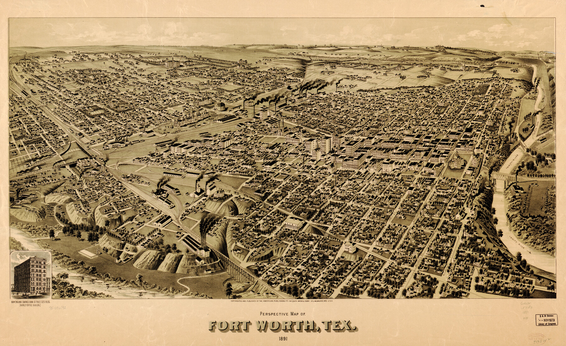
Perspective Map of Fort Worth, Tex.
-
Map/Doc
93472
-
Collection
Library of Congress
-
Object Dates
1891 (Creation Date)
-
People and Organizations
The American Publishing Co. (Publisher)
-
Counties
Tarrant
-
Subjects
Bird's Eye View City Pictorial
-
Height x Width
22.2 x 36.3 inches
56.4 x 92.2 cm
-
Comments
Bird's Eye View map. For more information see here. Prints available from the GLO courtesy of Library of Congress, Geography and Map Division.
Part of: Library of Congress


Neue Karte de Staates Texas für 1881.

Print $20.00
Neue Karte de Staates Texas für 1881.
1881
Size 19.3 x 25.6 inches
Map/Doc 93573
[Map showing T&P Lands in El Paso County]
![88936, [Map showing T&P Lands in El Paso County], Library of Congress](https://historictexasmaps.com/wmedia_w700/maps/88936.tif.jpg)
Print $20.00
[Map showing T&P Lands in El Paso County]
Size 22.6 x 17.5 inches
Map/Doc 88936
Houston, Texas (Looking South)

Print $20.00
Houston, Texas (Looking South)
1891
Size 41.1 x 25.3 inches
Map/Doc 93465
The Villa and Presidio of San Antonio de Bexar

The Villa and Presidio of San Antonio de Bexar
1935
Size 18.1 x 23.6 inches
Map/Doc 93564
Map showing the Houston & Texas Central Railroad and its connections

Print $20.00
Map showing the Houston & Texas Central Railroad and its connections
1867
Size 22.0 x 25.2 inches
Map/Doc 93604
Map of Glasscock County, Texas

Print $20.00
Map of Glasscock County, Texas
Size 22.7 x 18.3 inches
Map/Doc 88943
Map of Texas, showing the line of the Texas and New Orleans Rail Road, and its connections in the U.S. and adjacent territories.

Print $20.00
Map of Texas, showing the line of the Texas and New Orleans Rail Road, and its connections in the U.S. and adjacent territories.
1860
Size 22.0 x 31.1 inches
Map/Doc 93612

Map of Matagorda County, Texas

Print $20.00
Map of Matagorda County, Texas
1879
Size 30.7 x 27.4 inches
Map/Doc 88978
Interpretative map of wind erodibility. Gaines County, Texas

Interpretative map of wind erodibility. Gaines County, Texas
1986
Size 27.6 x 36.2 inches
Map/Doc 93561
You may also like
Flight Mission No. DQO-1K, Frame 153, Galveston County

Print $20.00
- Digital $50.00
Flight Mission No. DQO-1K, Frame 153, Galveston County
1952
Size 18.8 x 22.5 inches
Map/Doc 85006
Burnet County Highway Map

Print $20.00
- Digital $50.00
Burnet County Highway Map
Size 25.5 x 18.5 inches
Map/Doc 92471
San Jacinto River and Tributaries, Texas - Survey of 1939

Print $20.00
- Digital $50.00
San Jacinto River and Tributaries, Texas - Survey of 1939
1939
Size 28.0 x 40.3 inches
Map/Doc 60307
No. 2 Chart of Corpus Christi Pass, Texas

Print $20.00
- Digital $50.00
No. 2 Chart of Corpus Christi Pass, Texas
1878
Size 18.2 x 27.3 inches
Map/Doc 73027
Terrell County Rolled Sketch 31

Print $20.00
- Digital $50.00
Terrell County Rolled Sketch 31
1931
Size 24.4 x 28.4 inches
Map/Doc 7937
Railroad Track Map, H&TCRRCo., Falls County, Texas

Print $4.00
- Digital $50.00
Railroad Track Map, H&TCRRCo., Falls County, Texas
1918
Size 11.7 x 18.5 inches
Map/Doc 62854
[E. L. & R. R. RR. Co. Block B9 and other surveys along Yellow House Creek]
![90872, [E. L. & R. R. RR. Co. Block B9 and other surveys along Yellow House Creek], Twichell Survey Records](https://historictexasmaps.com/wmedia_w700/maps/90872-2.tif.jpg)
Print $3.00
- Digital $50.00
[E. L. & R. R. RR. Co. Block B9 and other surveys along Yellow House Creek]
Size 16.4 x 11.7 inches
Map/Doc 90872
[Sketch of Hicks Strip No. 2 between M. H. Hagaman and Z. C. Collier Surveys]
![91893, [Sketch of Hicks Strip No. 2 between M. H. Hagaman and Z. C. Collier Surveys], Twichell Survey Records](https://historictexasmaps.com/wmedia_w700/maps/91893-1.tif.jpg)
Print $20.00
- Digital $50.00
[Sketch of Hicks Strip No. 2 between M. H. Hagaman and Z. C. Collier Surveys]
Size 15.1 x 14.9 inches
Map/Doc 91893
Kleberg County Aerial Photograph Index Sheet 2

Print $20.00
- Digital $50.00
Kleberg County Aerial Photograph Index Sheet 2
1956
Size 19.4 x 23.4 inches
Map/Doc 83719
Geological Map of the route explored by Lieut. A.W. Whipple, Corps of Topl. Engrs. near the Parallel of 35° North Latitude from the Mississippi River to the Pacific Ocean 1853-1854

Print $20.00
- Digital $50.00
Geological Map of the route explored by Lieut. A.W. Whipple, Corps of Topl. Engrs. near the Parallel of 35° North Latitude from the Mississippi River to the Pacific Ocean 1853-1854
1854
Size 11.2 x 39.3 inches
Map/Doc 95750
Hutchinson County Sketch File 28

Print $6.00
- Digital $50.00
Hutchinson County Sketch File 28
1926
Size 11.3 x 8.8 inches
Map/Doc 27261
Bexar County Sketch File 1

Print $42.00
- Digital $50.00
Bexar County Sketch File 1
1848
Size 12.5 x 16.2 inches
Map/Doc 14465