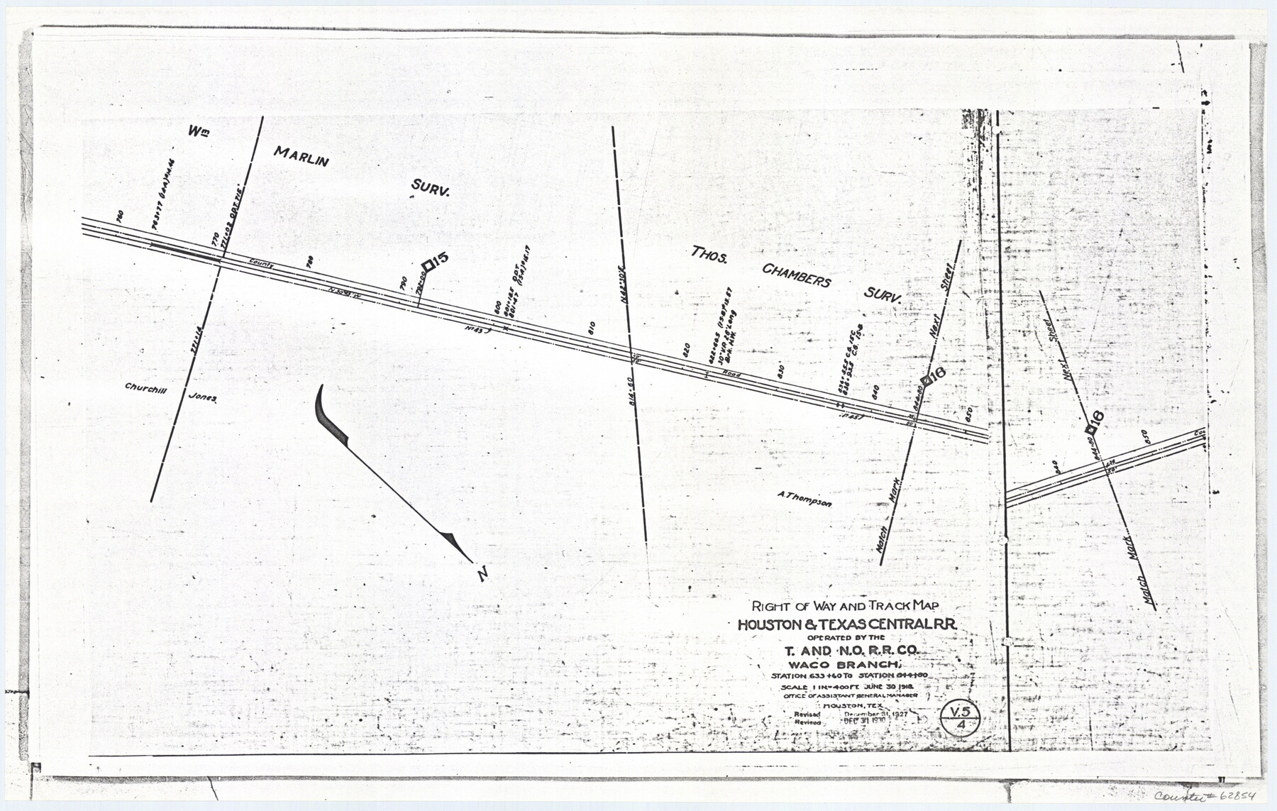
Railroad Track Map, H&TCRRCo., Falls County, Texas
Right of Way and Track Map
K-7-79 flat folder
-
Map/Doc
62854
-
Collection
General Map Collection
-
Object Dates
1918 (Creation Date)
-
Counties
Falls
-
Subjects
Railroads
-
Height x Width
11.7 x 18.5 inches
29.7 x 47.0 cm
-
Comments
Operated by the Texas and New Orleans Railroad Company, Waco Branch.
Part of: General Map Collection
Kinney County Working Sketch 6

Print $20.00
- Digital $50.00
Kinney County Working Sketch 6
1908
Size 19.6 x 23.9 inches
Map/Doc 70188
Presidio County Sketch File 108

Print $6.00
- Digital $50.00
Presidio County Sketch File 108
Size 10.9 x 8.5 inches
Map/Doc 41455

Flight Mission No. BRE-1P, Frame 123, Nueces County

Print $20.00
- Digital $50.00
Flight Mission No. BRE-1P, Frame 123, Nueces County
1956
Size 18.6 x 22.7 inches
Map/Doc 86689
Galveston County Working Sketch 6

Print $20.00
- Digital $50.00
Galveston County Working Sketch 6
1934
Size 43.5 x 38.0 inches
Map/Doc 69343
Photo Index of Texas Coast - Sheet 3 of 6

Print $20.00
- Digital $50.00
Photo Index of Texas Coast - Sheet 3 of 6
1954
Size 20.0 x 24.0 inches
Map/Doc 83441
Cameron County Rolled Sketch 19

Print $20.00
- Digital $50.00
Cameron County Rolled Sketch 19
Size 25.8 x 23.6 inches
Map/Doc 5465
Zavala County Working Sketch 27

Print $20.00
- Digital $50.00
Zavala County Working Sketch 27
1990
Size 22.3 x 27.5 inches
Map/Doc 62102
Brewster County Rolled Sketch 107

Print $20.00
- Digital $50.00
Brewster County Rolled Sketch 107
Size 22.2 x 11.2 inches
Map/Doc 5259
[Jack District]
![1992, [Jack District], General Map Collection](https://historictexasmaps.com/wmedia_w700/maps/1992.tif.jpg)
Print $40.00
- Digital $50.00
[Jack District]
1880
Size 52.7 x 43.4 inches
Map/Doc 1992
Atascosa County Sketch File 30

Print $18.00
- Digital $50.00
Atascosa County Sketch File 30
1900
Size 11.2 x 8.8 inches
Map/Doc 13816
Irion County Sketch File 11

Print $20.00
- Digital $50.00
Irion County Sketch File 11
1937
Size 22.2 x 17.5 inches
Map/Doc 11826
You may also like
The Republic County of Victoria. September 18, 1838

Print $20.00
The Republic County of Victoria. September 18, 1838
2020
Size 24.3 x 21.7 inches
Map/Doc 96296
Flight Mission No. BRA-6M, Frame 91, Jefferson County

Print $20.00
- Digital $50.00
Flight Mission No. BRA-6M, Frame 91, Jefferson County
1953
Size 18.5 x 22.4 inches
Map/Doc 85434

[Capitol Leagues in Southwest Hartley and Northwest Oldham Counties]
![90727, [Capitol Leagues in Southwest Hartley and Northwest Oldham Counties], Twichell Survey Records](https://historictexasmaps.com/wmedia_w700/maps/90727-1.tif.jpg)
Print $20.00
- Digital $50.00
[Capitol Leagues in Southwest Hartley and Northwest Oldham Counties]
Size 14.6 x 20.4 inches
Map/Doc 90727
Duval County Rolled Sketch HD

Print $20.00
- Digital $50.00
Duval County Rolled Sketch HD
1939
Size 22.8 x 32.8 inches
Map/Doc 5767
Lipscomb County Sketch File 3

Print $20.00
- Digital $50.00
Lipscomb County Sketch File 3
Size 36.5 x 8.4 inches
Map/Doc 10526
Swisher County Boundary File 1

Print $72.00
- Digital $50.00
Swisher County Boundary File 1
Size 9.0 x 4.5 inches
Map/Doc 59075
The Rand-McNally New Commercial Atlas Map of Texas

Print $20.00
The Rand-McNally New Commercial Atlas Map of Texas
1914
Size 28.6 x 42.4 inches
Map/Doc 78225

Flight Mission No. DAG-17K, Frame 76, Matagorda County

Print $20.00
- Digital $50.00
Flight Mission No. DAG-17K, Frame 76, Matagorda County
1952
Size 16.6 x 16.6 inches
Map/Doc 86335
Map of Dimmit County

Print $20.00
- Digital $50.00
Map of Dimmit County
1875
Size 21.9 x 24.0 inches
Map/Doc 3489
Travis County Sketch File 22

Print $6.00
- Digital $50.00
Travis County Sketch File 22
1875
Size 8.5 x 8.5 inches
Map/Doc 38327